Property Record
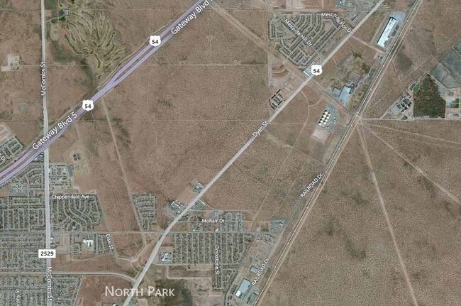
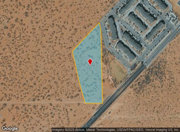
Dyer St, El Paso, TX 79934
NEARBY LISTINGS FOR SALE OR LEASE
Property Detail
Dyer St
El Paso
Tsp 1 Sec 1 T & P Surv
El Paso, TX
80 TSP 1 SEC 20 T & P SURV TR 2 (4.7033 AC)
X580-999-1200-7910
El Paso
Governmentalpublicusegeneral
Texas
0
4.70 AC
2025
Northeast
010212
DEMOGRAPHICS near Dyer St
1 Mile
3 Mile
5 Mile
2024 Total Population
4,251
33,138
81,247
2029 Population
4,272
33,412
81,832
Pop Growth 2024-2029
+ 0.49%
+ 0.83%
+ 0.72%
Average Age
28
33
35
2024 Total Households
1,571
11,380
28,644
HH Growth 2024-2029
+ 0.64%
+ 0.92%
+ 0.76%
Median Household Inc
$60,476
$56,018
$56,342
Avg Household Size
2.70
2.80
2.80
2024 Avg HH Vehicles
2.00
2.00
2.00
Median Home Value
$147,727
$140,186
$140,133
Median Year Built
2010
2002
1987
Nearby Places
Map Layers
Map Styles
 Street
 Aerial
- Restaurants
- Banks
- Shops
- Fitness
- Groceries
PUBLIC TRANSPORTATION
AIRPORT
El Paso International
DRIVE
WALK
Distance
El Paso International
29 min
15.9 mi
Freight Ports
Port of Corpus Christi
DRIVE
WALK
Distance
Port of Corpus Christi
694 min
703.8 mi
Nearby Properties
Address
Land Use
TOTAL SIZE
Lot Size
Zoning
Address
Land Use
TOTAL SIZE
Lot Size
Zoning
263,488 SF
13.88 AC
R3
Address
Land Use
TOTAL SIZE
Lot Size
Zoning
720,596 SF
23.98 AC
C2C
Address
Land Use
TOTAL SIZE
Lot Size
Zoning
123,824 SF
3.85 AC
A3
Address
Land Use
TOTAL SIZE
Lot Size
Zoning
76,082 SF
13.59 AC
Address
Land Use
TOTAL SIZE
Lot Size
Zoning
26,276 SF
1.53 AC
Address
Land Use
TOTAL SIZE
Lot Size
Zoning
424,325 SF
M1
Address
Land Use
TOTAL SIZE
Lot Size
Zoning
46,318 SF
4.92 AC
C3
Address
Land Use
TOTAL SIZE
Lot Size
Zoning
91,288 SF
14 AC
C1
Address
Land Use
TOTAL SIZE
Lot Size
Zoning
144,711 SF
10.50 AC
M1S
Address
Land Use
TOTAL SIZE
Lot Size
Zoning
39,270 SF
2.52 AC
C3
Address
Land Use
TOTAL SIZE
Lot Size
Zoning
77.84 AC
M1
Address
Land Use
TOTAL SIZE
Lot Size
Zoning
241,802 SF
9.81 AC
M1
Address
Land Use
TOTAL SIZE
Lot Size
Zoning
89,321 SF
7.28 AC
C4
Address
Land Use
TOTAL SIZE
Lot Size
Zoning
318,722 SF
50 AC
M1
Address
Land Use
TOTAL SIZE
Lot Size
Zoning
336.77 AC
RF
Address
Land Use
TOTAL SIZE
Lot Size
Zoning
229.68 AC
RF
Address
Land Use
TOTAL SIZE
Lot Size
Zoning
140,610 SF
10.71 AC
A2
Address
Land Use
TOTAL SIZE
Lot Size
Zoning
84,149 SF
6.52 AC
A2
Address
Land Use
TOTAL SIZE
Lot Size
Zoning
52,000 SF
4.44 AC
M1
Address
Land Use
TOTAL SIZE
Lot Size
Zoning
152,002 SF
9.73 AC
C1C
Address
Land Use
TOTAL SIZE
Lot Size
Zoning
88,064 SF
6.50 AC
A2S
Address
Land Use
TOTAL SIZE
Lot Size
Zoning
59,776 SF
25.14 AC
R3
Address
Land Use
TOTAL SIZE
Lot Size
Zoning
158,796 SF
13.90 AC
C4
Address
Land Use
TOTAL SIZE
Lot Size
Zoning
73,934 SF
5.81 AC
C4C
Address
Land Use
TOTAL SIZE
Lot Size
Zoning
25,282 SF
141.95 AC
M1
Address
Land Use
TOTAL SIZE
Lot Size
Zoning
47,550 SF
2.88 AC
C4
Address
Land Use
TOTAL SIZE
Lot Size
Zoning
88.99 AC
R3A
Address
Land Use
TOTAL SIZE
Lot Size
Zoning
18,536 SF
2.07 AC
M1S
Address
Land Use
TOTAL SIZE
Lot Size
Zoning
12,080 SF
3 AC
C4
The World's #1 Commercial Real Estate Marketplace
Connect with us
© 2025 CoStar Group
The information above has been obtained from sources believed reliable. While we do not doubt its accuracy we have not verified it and make no guarantee, warranty or representation about it. It is your responsibility to independently confirm its accuracy and completeness. Any projections, opinions, assumptions, or estimates used are for example only and do not represent the current or future performance of the property. The value of this transaction to you depends on tax and other factors which should be evaluated by your tax, financial, and legal advisors. You and your advisors should conduct a careful, independent investigation of the property to determine to your satisfaction the suitability of the property for your needs.