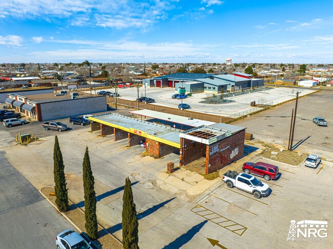
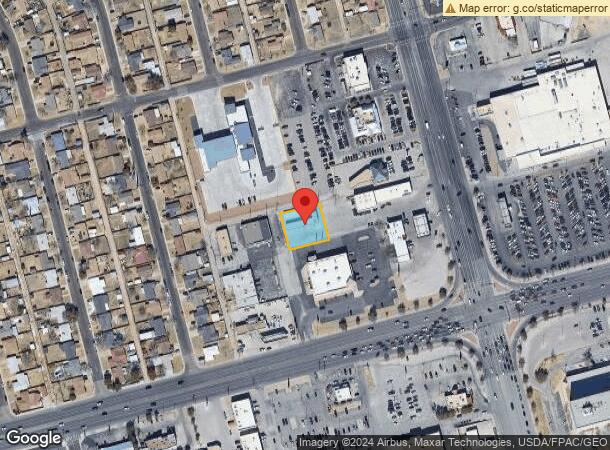
Property Record
E 42Nd St, Gardendale, TX 79758


NEARBY LISTINGS FOR SALE OR LEASE
Property Detail
E 42Nd St
Odessa, TX
Fleetwood
10100-02993-00500
FLEETWOOD BLOCK 21 LOT 20
Commercialnec
Ector
X
Texas
48135C0240E
20
2025
0.33 AC
2025
Midland & Odessa
003002
Other Market Areas
2,392 SF
DEMOGRAPHICS near E 42Nd St
1 Mile
3 Mile
5 Mile
2024 Total Population
15,010
64,499
123,679
2029 Population
14,759
63,454
122,594
Pop Growth 2024-2029
(1.67%)
(1.62%)
(0.88%)
Average Age
35
35
34
2024 Total Households
5,704
23,704
44,648
HH Growth 2024-2029
(1.93%)
(1.86%)
(1.09%)
Median Household Inc
$68,652
$60,424
$61,053
Avg Household Size
2.50
2.60
2.70
2024 Avg HH Vehicles
2.00
2.00
2.00
Median Home Value
$200,229
$170,629
$183,734
Median Year Built
1975
1973
1979
Nearby Places
Map Layers
Map Styles
 Street
 Aerial
- Restaurants
- Banks
- Shops
- Fitness
- Groceries
PUBLIC TRANSPORTATION
AIRPORT
Midland International Air And Space Port
DRIVE
WALK
Distance
Midland International Air And Space Port
19 min
12.0 mi
SALE & LEASE HISTORY
LISTING DATE
SALE/LEASE

Feb 08, 2024
For Sale
Nearby Properties
Address
Land Use
TOTAL SIZE
Lot Size
Zoning
Address
Land Use
TOTAL SIZE
Lot Size
Zoning
21,296 SF
541.62 AC
EF1
Address
Land Use
TOTAL SIZE
Lot Size
Zoning
Address
Land Use
TOTAL SIZE
Lot Size
Zoning
Address
Land Use
TOTAL SIZE
Lot Size
Zoning
22,304 SF
67.42 AC
EB4
Address
Land Use
TOTAL SIZE
Lot Size
Zoning
Address
Land Use
TOTAL SIZE
Lot Size
Zoning
54,990 SF
46.21 AC
ED5
Address
Land Use
TOTAL SIZE
Lot Size
Zoning
544,894 SF
20.41 AC
EF1
Address
Land Use
TOTAL SIZE
Lot Size
Zoning
Address
Land Use
TOTAL SIZE
Lot Size
Zoning
Address
Land Use
TOTAL SIZE
Lot Size
Zoning
Address
Land Use
TOTAL SIZE
Lot Size
Zoning
159,239 SF
6.64 AC
EE1
Address
Land Use
TOTAL SIZE
Lot Size
Zoning
57,566 SF
Address
Land Use
TOTAL SIZE
Lot Size
Zoning
87,558 SF
62.63 AC
ED3
Address
Land Use
TOTAL SIZE
Lot Size
Zoning
2,268 SF
15.91 AC
EB2
Address
Land Use
TOTAL SIZE
Lot Size
Zoning
Address
Land Use
TOTAL SIZE
Lot Size
Zoning
124,185 SF
9.10 AC
ED3
Address
Land Use
TOTAL SIZE
Lot Size
Zoning
192,022 SF
8.83 AC
ED3
Address
Land Use
TOTAL SIZE
Lot Size
Zoning
80,722 SF
20.09 AC
ED3
Address
Land Use
TOTAL SIZE
Lot Size
Zoning
3,336 SF
11.21 AC
EF5
Address
Land Use
TOTAL SIZE
Lot Size
Zoning
197,580 SF
8.77 AC
ED3
Address
Land Use
TOTAL SIZE
Lot Size
Zoning
36,084 SF
18.99 AC
EF3
Address
Land Use
TOTAL SIZE
Lot Size
Zoning
Address
Land Use
TOTAL SIZE
Lot Size
Zoning
5,200 SF
7.16 AC
EF7
Address
Land Use
TOTAL SIZE
Lot Size
Zoning
Address
Land Use
TOTAL SIZE
Lot Size
Zoning
155,744 SF
49.20 AC
EA7
Address
Land Use
TOTAL SIZE
Lot Size
Zoning
99,244 SF
4.66 AC
EE1
Address
Land Use
TOTAL SIZE
Lot Size
Zoning
2,512 SF
7.47 AC
EF7
Address
Land Use
TOTAL SIZE
Lot Size
Zoning
7,236 SF
10.80 AC
ED3
Address
Land Use
TOTAL SIZE
Lot Size
Zoning
19,401 SF
20.70 AC
ES2
Address
Land Use
TOTAL SIZE
Lot Size
Zoning
348,480 SF
82.30 AC
EC4
The World's #1 Commercial Real Estate Marketplace
Connect with us
© 2026 CoStar Group
The information above has been obtained from sources believed reliable. While we do not doubt its accuracy we have not verified it and make no guarantee, warranty or representation about it. It is your responsibility to independently confirm its accuracy and completeness. Any projections, opinions, assumptions, or estimates used are for example only and do not represent the current or future performance of the property. The value of this transaction to you depends on tax and other factors which should be evaluated by your tax, financial, and legal advisors. You and your advisors should conduct a careful, independent investigation of the property to determine to your satisfaction the suitability of the property for your needs.