Property Record
Highway 80, Pike Road, AL 36064
This Property Is For Sale
NEARBY LISTINGS FOR SALE OR LEASE
Property Detail
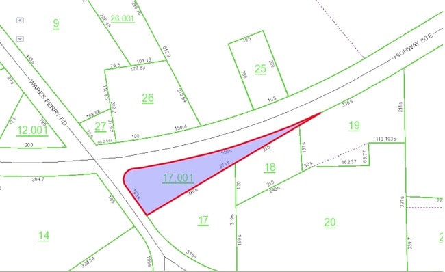
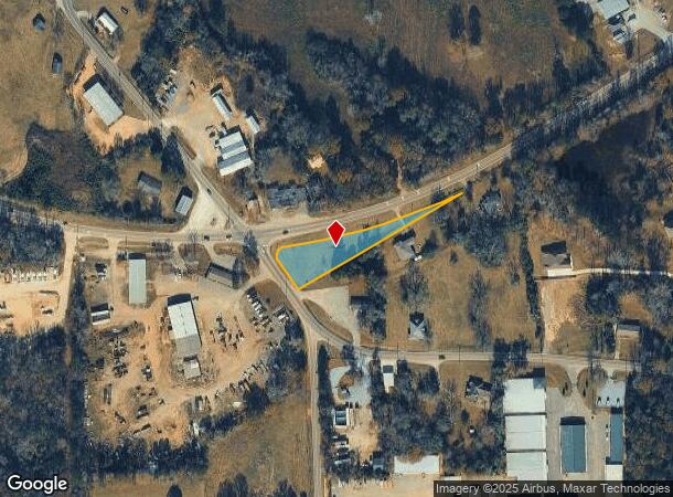
Highway 80
08-04-18-3-000-017.001
0.76 AC COMM AT SW/COR OF SEC 18, T16N R20E, TH E 702 FT, TH N 220 FT TO E R/W OF PIKE RD, TH NWLY 170 FT ALONG E R/W TO N
Commercialacreage
Montgomery
X
Alabama
01101C0251H
0.76 AC
2025
Outlying Montgomery Cnty
2025
Montgomery
005604
Montgomery, AL
DEMOGRAPHICS near Highway 80
1 Mile
3 Mile
5 Mile
2024 Total Population
779
17,125
41,607
2029 Population
757
16,736
40,297
Pop Growth 2024-2029
(2.82%)
(2.27%)
(3.15%)
Average Age
38
39
39
2024 Total Households
290
5,988
15,885
HH Growth 2024-2029
(2.76%)
(2.49%)
(3.46%)
Median Household Inc
$90,908
$93,682
$92,162
Avg Household Size
2.70
2.60
2.50
2024 Avg HH Vehicles
2.00
2.00
2.00
Median Home Value
$232,407
$280,039
$277,582
Median Year Built
2001
2003
2001
Nearby Places
Map Layers
Map Styles
 Street
 Aerial
- Restaurants
- Banks
- Shops
- Fitness
- Groceries
PUBLIC TRANSPORTATION
AIRPORT
Montgomery Regional (Dannelly Field)
DRIVE
WALK
Distance
Montgomery Regional (Dannelly Field)
27 min
21.1 mi
Freight Ports
Port of Panama City
DRIVE
WALK
Distance
Port of Panama City
238 min
188.0 mi
Nearby Properties
Address
Land Use
TOTAL SIZE
Lot Size
Zoning
Address
Land Use
TOTAL SIZE
Lot Size
Zoning
25,762 SF
35.04 AC
PUD
Address
Land Use
TOTAL SIZE
Lot Size
Zoning
5,118 SF
22.75 AC
R-65-M
Address
Land Use
TOTAL SIZE
Lot Size
Zoning
208,799 SF
17.34 AC
O-2
Address
Land Use
TOTAL SIZE
Lot Size
Zoning
160,604 SF
35.85 AC
B-2
Address
Land Use
TOTAL SIZE
Lot Size
Zoning
4,142 SF
25.96 AC
PUD
Address
Land Use
TOTAL SIZE
Lot Size
Zoning
344,095 SF
30.02 AC
Address
Land Use
TOTAL SIZE
Lot Size
Zoning
170,644 SF
12.34 AC
Address
Land Use
TOTAL SIZE
Lot Size
Zoning
217,723 SF
23.90 AC
B-2
Address
Land Use
TOTAL SIZE
Lot Size
Zoning
152,523 SF
13.96 AC
PUD
Address
Land Use
TOTAL SIZE
Lot Size
Zoning
56,956 SF
10.37 AC
B-2
Address
Land Use
TOTAL SIZE
Lot Size
Zoning
52,600 SF
11.63 AC
Address
Land Use
TOTAL SIZE
Lot Size
Zoning
9,792 SF
160 AC
Address
Land Use
TOTAL SIZE
Lot Size
Zoning
117,633 SF
52.48 AC
Address
Land Use
TOTAL SIZE
Lot Size
Zoning
228,855 SF
15.70 AC
M-1
Address
Land Use
TOTAL SIZE
Lot Size
Zoning
96,764 SF
13.64 AC
M-1
Address
Land Use
TOTAL SIZE
Lot Size
Zoning
168,209 SF
21.62 AC
Address
Land Use
TOTAL SIZE
Lot Size
Zoning
55,215 SF
9.78 AC
B-2
Address
Land Use
TOTAL SIZE
Lot Size
Zoning
168,209 SF
21.62 AC
Address
Land Use
TOTAL SIZE
Lot Size
Zoning
64,898 SF
2.65 AC
B-2
Address
Land Use
TOTAL SIZE
Lot Size
Zoning
115,292 SF
49.50 AC
M-1
Address
Land Use
TOTAL SIZE
Lot Size
Zoning
113,724 SF
12.84 AC
B-2
Address
Land Use
TOTAL SIZE
Lot Size
Zoning
123,376 SF
23 AC
Address
Land Use
TOTAL SIZE
Lot Size
Zoning
73,990 SF
8.49 AC
B-2
Address
Land Use
TOTAL SIZE
Lot Size
Zoning
36,514 SF
4.57 AC
R-65-M
Address
Land Use
TOTAL SIZE
Lot Size
Zoning
34.70 AC
B-2
Address
Land Use
TOTAL SIZE
Lot Size
Zoning
58,052 SF
2.55 AC
B-2
Address
Land Use
TOTAL SIZE
Lot Size
Zoning
55,345 SF
6.78 AC
Address
Land Use
TOTAL SIZE
Lot Size
Zoning
9,806 SF
119.29 AC
Address
Land Use
TOTAL SIZE
Lot Size
Zoning
11,100 SF
10.50 AC
Address
Land Use
TOTAL SIZE
Lot Size
Zoning
53,827 SF
1.98 AC
B-2
The World's #1 Commercial Real Estate Marketplace
Connect with us
© 2025 CoStar Group
The information above has been obtained from sources believed reliable. While we do not doubt its accuracy we have not verified it and make no guarantee, warranty or representation about it. It is your responsibility to independently confirm its accuracy and completeness. Any projections, opinions, assumptions, or estimates used are for example only and do not represent the current or future performance of the property. The value of this transaction to you depends on tax and other factors which should be evaluated by your tax, financial, and legal advisors. You and your advisors should conduct a careful, independent investigation of the property to determine to your satisfaction the suitability of the property for your needs.