Property Record
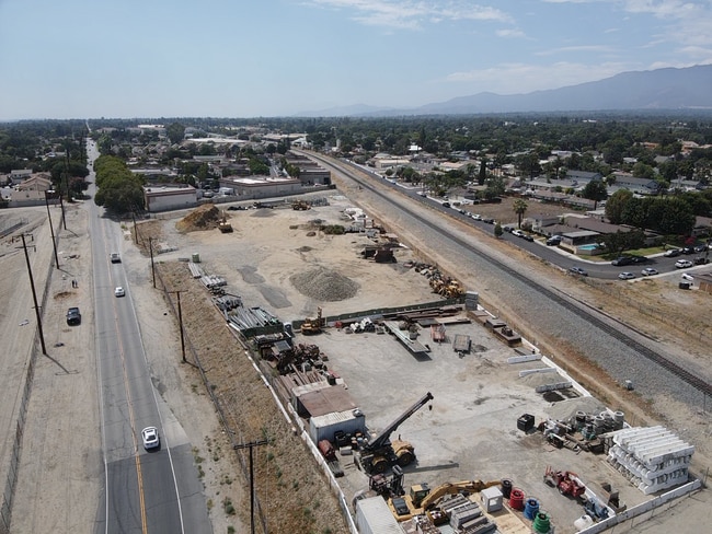
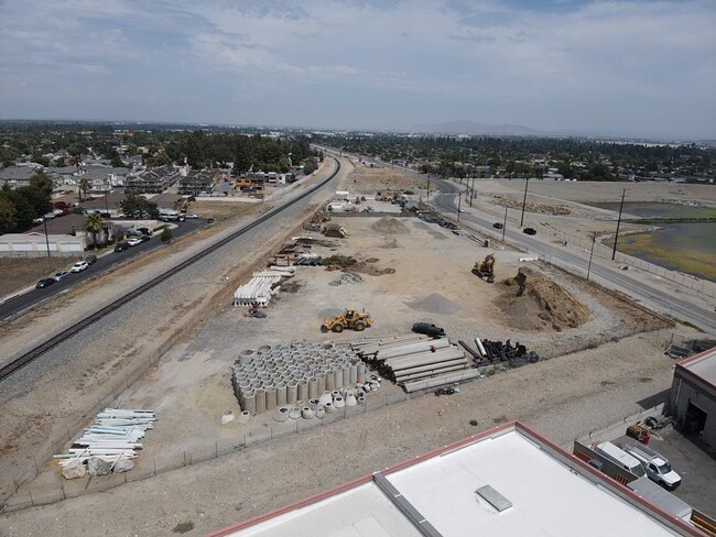
E 8Th St, Upland, CA 91786

This Property Is For Sale
Property Detail
E 8Th St
Riverside-San Bernardino-Ontario, CA
PTN SW 1/4 SE 1/4 SEC 8 TP 1S R 7W DESC AS COM 33 FT N AND 744.16 FT E OF SW COR SD SW 1/4 SE 1/4 TH N 21 DEG O1 M1N OO SECONDS W 344.15 FT TO A PT 1N S L1 AT AND SF RR R/W TH SELY ALG SD R/W TO E L1 SD SW 1/4 SE 1/4 TH S ON SD E L1 TO A PT 33 FT N O
1046-521-01
SAN BERNARDINO
Vacantlandnec
California
B and X Area of moderate flood hazard, usually the area between the limits of the 100-year and 500-year floods.
1
2025
3 AC
2025
Upland/Montclair
000824
Inland Empire (California)
NEARBY LISTINGS FOR SALE OR LEASE
DEMOGRAPHICS near E 8Th St
1 mile
3 mile
5 mile
2025 Total Population
26,439
183,530
396,417
2030 Population
26,566
184,670
398,901
Pop Growth 2025-2030
+ 0.48%
+ 0.62%
+ 0.63%
Average Age
37
38
38
2025 Total Households
8,184
58,540
127,592
HH Growth 2025-2030
+ 0.61%
+ 0.66%
+ 0.70%
Median Household Inc
$76,205
$89,761
$95,062
Avg Household Size
3.10
3.00
3.00
2025 Avg HH Vehicles
2.00
2.00
2.00
Median Home Value
$644,742
$676,055
$706,507
Median Year Built
1975
1973
1978
Nearby Places
Map Layers
Map Styles
 Street
 Aerial
Transit
 Traffic
 Biking
Places
Listings with unknown addresses are not visible on the map
- Restaurants
- Banks
- Shops
- Fitness
- Groceries
PUBLIC TRANSPORTATION
TRANSIT/SUBWAY
Upland (San Bernardino Line - Southern California Regional Rail Authority (Metrolink))
Drive
Walk
Distance
Upland (San Bernardino Line - Southern California Regional Rail Authority (Metrolink))
3 min
20 min
1.0 mi
COMMUTER RAIL
Upland (San Bernardino Line - Southern California Regional Rail Authority (Metrolink))
Drive
Walk
Distance
Upland (San Bernardino Line - Southern California Regional Rail Authority (Metrolink))
3 min
20 min
1.0 mi
Drive
Walk
Distance
7 min
3.6 mi
AIRPORT
Ontario International
Drive
Walk
Distance
Ontario International
9 min
4.3 mi
John Wayne/Orange County
Drive
Walk
Distance
John Wayne/Orange County
53 min
42.0 mi
Long Beach (Daugherty Field)
Drive
Walk
Distance
Long Beach (Daugherty Field)
60 min
46.0 mi
Freight Ports
Port of Long Beach
Drive
Walk
Distance
Port of Long Beach
66 min
51.7 mi
Nearby Properties
Address
Land Use
TOTAL SIZE
Lot Size
Zoning
Address
Land Use
TOTAL SIZE
Lot Size
Zoning
376,610 SF
25.22 AC
Address
Land Use
TOTAL SIZE
Lot Size
Zoning
244,370 SF
59.72 AC
Address
Land Use
TOTAL SIZE
Lot Size
Zoning
539,128 SF
10.24 AC
Address
Land Use
TOTAL SIZE
Lot Size
Zoning
545,161 SF
11.10 AC
Address
Land Use
TOTAL SIZE
Lot Size
Zoning
1,052,840 SF
41.85 AC
Address
Land Use
TOTAL SIZE
Lot Size
Zoning
531,988 SF
9.83 AC
Address
Land Use
TOTAL SIZE
Lot Size
Zoning
440,209 SF
10.34 AC
Address
Land Use
TOTAL SIZE
Lot Size
Zoning
468,682 SF
19.40 AC
Address
Land Use
TOTAL SIZE
Lot Size
Zoning
167,512 SF
8.35 AC
Address
Land Use
TOTAL SIZE
Lot Size
Zoning
251,645 SF
4.50 AC
Address
Land Use
TOTAL SIZE
Lot Size
Zoning
123,833 SF
11.23 AC
Address
Land Use
TOTAL SIZE
Lot Size
Zoning
573,220 SF
32.33 AC
Address
Land Use
TOTAL SIZE
Lot Size
Zoning
780,648 SF
13.59 AC
Address
Land Use
TOTAL SIZE
Lot Size
Zoning
553,882 SF
24.59 AC
Address
Land Use
TOTAL SIZE
Lot Size
Zoning
401,226 SF
17.62 AC
Address
Land Use
TOTAL SIZE
Lot Size
Zoning
125,663 SF
7.04 AC
Address
Land Use
TOTAL SIZE
Lot Size
Zoning
502,917 SF
35.94 AC
Address
Land Use
TOTAL SIZE
Lot Size
Zoning
340,104 SF
8.95 AC
Address
Land Use
TOTAL SIZE
Lot Size
Zoning
250,200 SF
15.06 AC
Address
Land Use
TOTAL SIZE
Lot Size
Zoning
83,562 SF
10.06 AC
Address
Land Use
TOTAL SIZE
Lot Size
Zoning
249,672 SF
13.80 AC
Address
Land Use
TOTAL SIZE
Lot Size
Zoning
405,970 SF
19.23 AC
Address
Land Use
TOTAL SIZE
Lot Size
Zoning
397,875 SF
14.13 AC
Address
Land Use
TOTAL SIZE
Lot Size
Zoning
175,000 SF
15.24 AC
Address
Land Use
TOTAL SIZE
Lot Size
Zoning
173,531 SF
2.52 AC
Address
Land Use
TOTAL SIZE
Lot Size
Zoning
504,530 SF
22.76 AC
Address
Land Use
TOTAL SIZE
Lot Size
Zoning
120,939 SF
3.87 AC
Address
Land Use
TOTAL SIZE
Lot Size
Zoning
73,190 SF
5.43 AC
Address
Land Use
TOTAL SIZE
Lot Size
Zoning
106,212 SF
5.33 AC
Address
Land Use
TOTAL SIZE
Lot Size
Zoning
The World's #1 Commercial Real Estate Marketplace
Connect with us
© 2026 CoStar Group
The information above has been obtained from sources believed reliable. While we do not doubt its accuracy we have not verified it and make no guarantee, warranty or representation about it. It is your responsibility to independently confirm its accuracy and completeness. Any projections, opinions, assumptions, or estimates used are for example only and do not represent the current or future performance of the property. The value of this transaction to you depends on tax and other factors which should be evaluated by your tax, financial, and legal advisors. You and your advisors should conduct a careful, independent investigation of the property to determine to your satisfaction the suitability of the property for your needs.