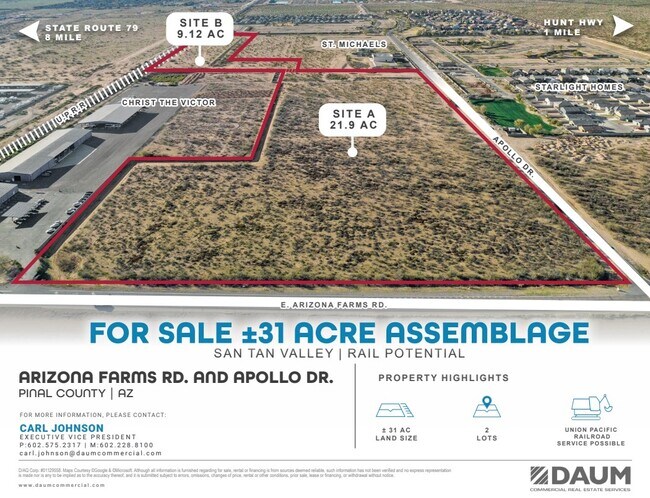
Property Record
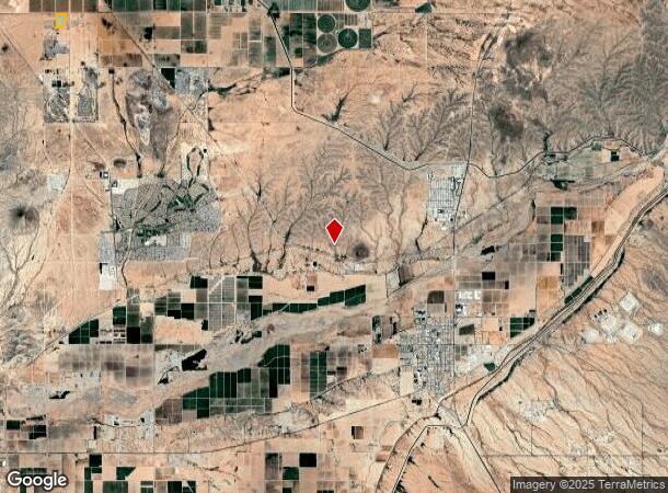
E Arizona Farms Rd, Florence, AZ 85132
NEARBY LISTINGS FOR SALE OR LEASE
Property Detail
E Arizona Farms Rd
Phoenix-Mesa-Scottsdale, AZ
Magma Buttes Ranches
200-58-002A
COM @ NW COR OF SEC 2-4S-8E TH S-40.0 TH E-1258.20 TO NW COR LOT 2 & POB TH E-922.03 TH S-473.63 TH W-292.97 TH S-822.62 TH W- 627 .16 TH N-1298.02 TO POB SEC 2-4S-8E 953092 SQ FT 21.88 AC
Vacantlandnec
Pinal
X
Arizona
04021C0850E
2
2024
21.88 AC
2025
Pinal County
000804
Phoenix
DEMOGRAPHICS near E Arizona Farms Rd
1 Mile
3 Mile
5 Mile
2024 Total Population
1,098
17,762
53,572
2029 Population
1,413
22,587
68,106
Pop Growth 2024-2029
+ 28.69%
+ 27.16%
+ 27.13%
Average Age
33
34
38
2024 Total Households
322
5,422
17,649
HH Growth 2024-2029
+ 28.57%
+ 27.04%
+ 27.11%
Median Household Inc
$94,816
$74,335
$81,937
Avg Household Size
3.20
3.20
3.00
2024 Avg HH Vehicles
3.00
2.00
2.00
Median Home Value
$306,731
$311,763
$328,496
Median Year Built
2008
2007
2007
Nearby Places
Map Layers
Map Styles
 Street
 Aerial
- Restaurants
- Banks
- Shops
- Fitness
- Groceries
PUBLIC TRANSPORTATION
AIRPORT
Phoenix-Mesa Gateway
DRIVE
WALK
Distance
Phoenix-Mesa Gateway
43 min
26.9 mi
Freight Ports
Port of San Diego
DRIVE
WALK
Distance
Port of San Diego
417 min
379.8 mi
SALE & LEASE HISTORY
LISTING DATE
SALE/LEASE

Sep 24, 2016
For Sale
Feb 27, 2023
For Sale
Nearby Properties
Address
Land Use
TOTAL SIZE
Lot Size
Zoning
Address
Land Use
TOTAL SIZE
Lot Size
Zoning
583,508 SF
32.12 AC
UNDESIGNAT
Address
Land Use
TOTAL SIZE
Lot Size
Zoning
388,169 SF
33.33 AC
UNDESIGNAT
Address
Land Use
TOTAL SIZE
Lot Size
Zoning
199,261 SF
19.06 AC
UNDESIGNAT
Address
Land Use
TOTAL SIZE
Lot Size
Zoning
128,660 SF
4.80 AC
UNDESIGNAT
Address
Land Use
TOTAL SIZE
Lot Size
Zoning
303,040 SF
12.34 AC
Address
Land Use
TOTAL SIZE
Lot Size
Zoning
11.58 AC
Address
Land Use
TOTAL SIZE
Lot Size
Zoning
102,629 SF
17.85 AC
UNDESIGNAT
Address
Land Use
TOTAL SIZE
Lot Size
Zoning
51,000 SF
5.71 AC
Address
Land Use
TOTAL SIZE
Lot Size
Zoning
71,889 SF
10.43 AC
Address
Land Use
TOTAL SIZE
Lot Size
Zoning
27,177 SF
125.23 AC
Address
Land Use
TOTAL SIZE
Lot Size
Zoning
89,998 SF
7.92 AC
Address
Land Use
TOTAL SIZE
Lot Size
Zoning
38,044 SF
1.62 AC
UNDESIGNAT
Address
Land Use
TOTAL SIZE
Lot Size
Zoning
19.98 AC
UNDESIGNAT
Address
Land Use
TOTAL SIZE
Lot Size
Zoning
Address
Land Use
TOTAL SIZE
Lot Size
Zoning
56,028 SF
2.44 AC
UNDESIGNAT
Address
Land Use
TOTAL SIZE
Lot Size
Zoning
32.30 AC
Address
Land Use
TOTAL SIZE
Lot Size
Zoning
39,036 SF
4.88 AC
UNDESIGNAT
Address
Land Use
TOTAL SIZE
Lot Size
Zoning
14,990 SF
6.44 AC
UNDESIGNAT
Address
Land Use
TOTAL SIZE
Lot Size
Zoning
12,100 SF
2.40 AC
Address
Land Use
TOTAL SIZE
Lot Size
Zoning
Address
Land Use
TOTAL SIZE
Lot Size
Zoning
11,100 SF
3.10 AC
UNDESIGNAT
Address
Land Use
TOTAL SIZE
Lot Size
Zoning
21,096 SF
6.33 AC
Address
Land Use
TOTAL SIZE
Lot Size
Zoning
17,914 SF
2.23 AC
UNDESIGNAT
Address
Land Use
TOTAL SIZE
Lot Size
Zoning
7,636 SF
3.56 AC
Address
Land Use
TOTAL SIZE
Lot Size
Zoning
210.16 AC
UNDESIGNAT
Address
Land Use
TOTAL SIZE
Lot Size
Zoning
784 SF
3.84 AC
Address
Land Use
TOTAL SIZE
Lot Size
Zoning
8,564 SF
1.53 AC
Address
Land Use
TOTAL SIZE
Lot Size
Zoning
5,305 SF
0.66 AC
UNDESIGNAT
Address
Land Use
TOTAL SIZE
Lot Size
Zoning
5,308 SF
1.51 AC
Address
Land Use
TOTAL SIZE
Lot Size
Zoning
3.96 AC
The World's #1 Commercial Real Estate Marketplace
Connect with us
© 2026 CoStar Group
The information above has been obtained from sources believed reliable. While we do not doubt its accuracy we have not verified it and make no guarantee, warranty or representation about it. It is your responsibility to independently confirm its accuracy and completeness. Any projections, opinions, assumptions, or estimates used are for example only and do not represent the current or future performance of the property. The value of this transaction to you depends on tax and other factors which should be evaluated by your tax, financial, and legal advisors. You and your advisors should conduct a careful, independent investigation of the property to determine to your satisfaction the suitability of the property for your needs.