Property Record
E Aviation Way, Newnan, GA 30263
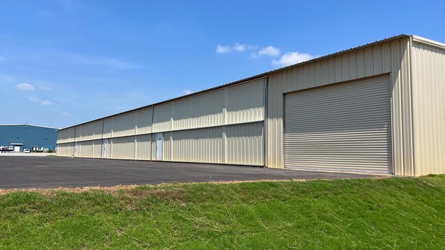
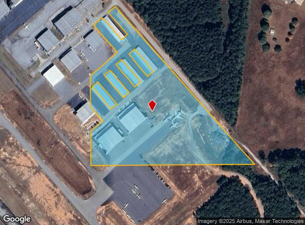
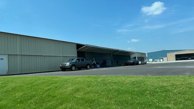
This Property Is For Sale
NEARBY LISTINGS FOR SALE OR LEASE
Property Detail
E Aviation Way
089-2091-013
16.03 AC TR 2 LL 91 LD 2 (AIRPORT PROPERTY)
Aircraft
Coweta
X
Georgia
13077C0234D
91
0
16.03 AC
2025
Fayette/Coweta County
170200
Atlanta
37,520 SF
Atlanta-Sandy Springs-Roswell, GA
DEMOGRAPHICS near E Aviation Way
1 Mile
3 Mile
5 Mile
2024 Total Population
220
4,906
44,164
2029 Population
246
5,533
49,557
Pop Growth 2024-2029
+ 11.82%
+ 12.78%
+ 12.21%
Average Age
41
39
38
2024 Total Households
80
1,774
16,658
HH Growth 2024-2029
+ 11.25%
+ 12.91%
+ 12.26%
Median Household Inc
$87,500
$72,488
$75,127
Avg Household Size
2.70
2.70
2.60
2024 Avg HH Vehicles
3.00
2.00
2.00
Median Home Value
$350,000
$281,540
$267,805
Median Year Built
1994
1993
2000
Nearby Places
Map Layers
Map Styles
 Street
 Aerial
- Restaurants
- Banks
- Shops
- Fitness
- Groceries
PUBLIC TRANSPORTATION
AIRPORT
Hartsfield - Jackson Atlanta International
DRIVE
WALK
Distance
Hartsfield - Jackson Atlanta International
45 min
35.1 mi
Freight Ports
Port of Panama City
DRIVE
WALK
Distance
Port of Panama City
308 min
251.9 mi
Nearby Properties
Address
Land Use
TOTAL SIZE
Lot Size
Zoning
Address
Land Use
TOTAL SIZE
Lot Size
Zoning
409,449 SF
93.83 AC
R1
Address
Land Use
TOTAL SIZE
Lot Size
Zoning
1,514,040 SF
147.92 AC
C1
Address
Land Use
TOTAL SIZE
Lot Size
Zoning
1,396,640 SF
78.52 AC
C1
Address
Land Use
TOTAL SIZE
Lot Size
Zoning
1,002,450 SF
62.54 AC
R1
Address
Land Use
TOTAL SIZE
Lot Size
Zoning
562,800 SF
34.39 AC
R1
Address
Land Use
TOTAL SIZE
Lot Size
Zoning
99,789 SF
0.88 AC
R1
Address
Land Use
TOTAL SIZE
Lot Size
Zoning
271,408 SF
30.33 AC
R1
Address
Land Use
TOTAL SIZE
Lot Size
Zoning
237,975 SF
20 AC
C1
Address
Land Use
TOTAL SIZE
Lot Size
Zoning
42,670 SF
129 AC
R1
Address
Land Use
TOTAL SIZE
Lot Size
Zoning
60.26 AC
C1
Address
Land Use
TOTAL SIZE
Lot Size
Zoning
57,700 SF
2.53 AC
R1
Address
Land Use
TOTAL SIZE
Lot Size
Zoning
37.08 AC
R1
Address
Land Use
TOTAL SIZE
Lot Size
Zoning
46,688 SF
27.62 AC
R1
Address
Land Use
TOTAL SIZE
Lot Size
Zoning
27,000 SF
28.75 AC
R1
Address
Land Use
TOTAL SIZE
Lot Size
Zoning
38,280 SF
12.69 AC
002
Address
Land Use
TOTAL SIZE
Lot Size
Zoning
30,800 SF
0.69 AC
R1
Address
Land Use
TOTAL SIZE
Lot Size
Zoning
73,600 SF
44.43 AC
M
Address
Land Use
TOTAL SIZE
Lot Size
Zoning
19,520 SF
76.90 AC
R1
Address
Land Use
TOTAL SIZE
Lot Size
Zoning
24,219 SF
20.15 AC
R1
Address
Land Use
TOTAL SIZE
Lot Size
Zoning
36,000 SF
4.59 AC
R1
Address
Land Use
TOTAL SIZE
Lot Size
Zoning
11,801 SF
15.16 AC
R1
Address
Land Use
TOTAL SIZE
Lot Size
Zoning
30,823 SF
1.02 AC
R1
Address
Land Use
TOTAL SIZE
Lot Size
Zoning
9,108 SF
Address
Land Use
TOTAL SIZE
Lot Size
Zoning
34,380 SF
6.29 AC
R1
Address
Land Use
TOTAL SIZE
Lot Size
Zoning
23,784 SF
3.01 AC
RFA
Address
Land Use
TOTAL SIZE
Lot Size
Zoning
351 SF
79.74 AC
R1
Address
Land Use
TOTAL SIZE
Lot Size
Zoning
78.14 AC
001
The World's #1 Commercial Real Estate Marketplace
Connect with us
© 2026 CoStar Group
The information above has been obtained from sources believed reliable. While we do not doubt its accuracy we have not verified it and make no guarantee, warranty or representation about it. It is your responsibility to independently confirm its accuracy and completeness. Any projections, opinions, assumptions, or estimates used are for example only and do not represent the current or future performance of the property. The value of this transaction to you depends on tax and other factors which should be evaluated by your tax, financial, and legal advisors. You and your advisors should conduct a careful, independent investigation of the property to determine to your satisfaction the suitability of the property for your needs.