Property Record
745 S Indianola Ave, Sanger, CA 93657


NEARBY LISTINGS FOR SALE OR LEASE
Property Detail
745 S Indianola Ave
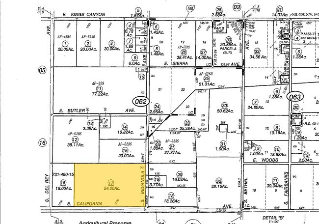
314-062-17
Parkhursts South Villa Addition
Orchard
54 AC IN S1/2 OF SW1/4 SEC 9 T14R22
X
Fresno
06019C2155H
California
2025
54 AC
2025
E Outlying Fresno County
005916
Fresno
3,318 SF
Fresno, CA
DEMOGRAPHICS near 745 S Indianola Ave
1 Mile
3 Mile
5 Mile
2024 Total Population
3,236
28,448
43,055
2029 Population
3,268
28,839
43,765
Pop Growth 2024-2029
+ 0.99%
+ 1.37%
+ 1.65%
Average Age
34
35
35
2024 Total Households
952
8,148
12,349
HH Growth 2024-2029
+ 0.95%
+ 1.30%
+ 1.58%
Median Household Inc
$103,274
$64,065
$74,432
Avg Household Size
3.30
3.40
3.40
2024 Avg HH Vehicles
2.00
2.00
2.00
Median Home Value
$355,032
$320,783
$347,386
Median Year Built
2001
1978
1984
Nearby Places
Map Layers
Map Styles
 Street
 Aerial
- Restaurants
- Banks
- Shops
- Fitness
- Groceries
PUBLIC TRANSPORTATION
AIRPORT
Fresno Yosemite International
DRIVE
WALK
Distance
Fresno Yosemite International
18 min
10.2 mi
Freight Ports
Port of Stockton
DRIVE
WALK
Distance
Port of Stockton
169 min
140.1 mi
SALE & LEASE HISTORY
LISTING DATE
SALE/LEASE

Sep 06, 2017
For Sale
Nearby Properties
Address
Land Use
TOTAL SIZE
Lot Size
Zoning
Address
Land Use
TOTAL SIZE
Lot Size
Zoning
119,762 SF
7.67 AC
M1
Address
Land Use
TOTAL SIZE
Lot Size
Zoning
234,271 SF
16.39 AC
M2
Address
Land Use
TOTAL SIZE
Lot Size
Zoning
109,374 SF
8.61 AC
RM25
Address
Land Use
TOTAL SIZE
Lot Size
Zoning
165,948 SF
16.88 AC
C2
Address
Land Use
TOTAL SIZE
Lot Size
Zoning
71,102 SF
3.56 AC
Address
Land Use
TOTAL SIZE
Lot Size
Zoning
87,150 SF
7.26 AC
RM25
Address
Land Use
TOTAL SIZE
Lot Size
Zoning
67,266 SF
3.35 AC
Address
Land Use
TOTAL SIZE
Lot Size
Zoning
51,204 SF
3.61 AC
RS3
Address
Land Use
TOTAL SIZE
Lot Size
Zoning
158.81 AC
AE20
Address
Land Use
TOTAL SIZE
Lot Size
Zoning
54,026 SF
10.83 AC
MH
Address
Land Use
TOTAL SIZE
Lot Size
Zoning
54,050 SF
6.27 AC
CP
Address
Land Use
TOTAL SIZE
Lot Size
Zoning
44,811 SF
4.53 AC
Address
Land Use
TOTAL SIZE
Lot Size
Zoning
74,874 SF
8.52 AC
RM25
Address
Land Use
TOTAL SIZE
Lot Size
Zoning
55,440 SF
2.55 AC
R4
Address
Land Use
TOTAL SIZE
Lot Size
Zoning
924 SF
154 AC
AE20
Address
Land Use
TOTAL SIZE
Lot Size
Zoning
46,912 SF
2.82 AC
R2
Address
Land Use
TOTAL SIZE
Lot Size
Zoning
9,190 SF
0.43 AC
RM25
Address
Land Use
TOTAL SIZE
Lot Size
Zoning
33,524 SF
36.90 AC
AE20
Address
Land Use
TOTAL SIZE
Lot Size
Zoning
15,403 SF
0.34 AC
CR
Address
Land Use
TOTAL SIZE
Lot Size
Zoning
97,815 SF
9.80 AC
C2
Address
Land Use
TOTAL SIZE
Lot Size
Zoning
13,717 SF
1.03 AC
C2
Address
Land Use
TOTAL SIZE
Lot Size
Zoning
58,693 SF
9.85 AC
AE20
Address
Land Use
TOTAL SIZE
Lot Size
Zoning
33,480 SF
1.81 AC
RM2
Address
Land Use
TOTAL SIZE
Lot Size
Zoning
12,527 SF
3.97 AC
C2
Address
Land Use
TOTAL SIZE
Lot Size
Zoning
156.04 AC
AE20
Address
Land Use
TOTAL SIZE
Lot Size
Zoning
14,888 SF
1.25 AC
CP
Address
Land Use
TOTAL SIZE
Lot Size
Zoning
29,641 SF
9.58 AC
R16
Address
Land Use
TOTAL SIZE
Lot Size
Zoning
23,501 SF
1.89 AC
C2
Address
Land Use
TOTAL SIZE
Lot Size
Zoning
6,500 SF
0.65 AC
CP
Address
Land Use
TOTAL SIZE
Lot Size
Zoning
1,058 SF
77.22 AC
AE20
The World's #1 Commercial Real Estate Marketplace
Connect with us
© 2025 CoStar Group
The information above has been obtained from sources believed reliable. While we do not doubt its accuracy we have not verified it and make no guarantee, warranty or representation about it. It is your responsibility to independently confirm its accuracy and completeness. Any projections, opinions, assumptions, or estimates used are for example only and do not represent the current or future performance of the property. The value of this transaction to you depends on tax and other factors which should be evaluated by your tax, financial, and legal advisors. You and your advisors should conduct a careful, independent investigation of the property to determine to your satisfaction the suitability of the property for your needs.