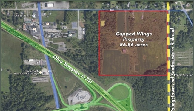
Property Record
237 Calla Rd E, Youngstown, OH 44514
Current Lease Availabilities
Property Detail
237 Calla Rd E
Youngstown-Warren, OH
SEC 11
05-040-0-003.00-0
MAHONING
Agriculturalland
Ohio
OI
25 AC
2025
Mahoning County
2025
Youngstown/Warren/Boardman
813501
NEARBY LISTINGS FOR SALE OR LEASE
DEMOGRAPHICS near 237 Calla Rd E
1 mile
3 mile
5 mile
2025 Total Population
1,125
12,524
47,613
2030 Population
1,137
12,415
47,107
Pop Growth 2025-2030
+ 1.07%
(0.87%)
(1.06%)
Average Age
53
48
45
2025 Total Households
487
5,588
20,863
HH Growth 2025-2030
+ 1.44%
(0.79%)
(1.04%)
Median Household Inc
$68,881
$72,841
$73,033
Avg Household Size
2.00
2.10
2.20
2025 Avg HH Vehicles
2.00
2.00
2.00
Median Home Value
$182,272
$236,135
$206,882
Median Year Built
1990
1981
1973
Nearby Places
Map Layers
Map Styles
 Street
 Aerial
Layers
 Traffic
 Biking
Places
Listings with unknown addresses are not visible on the map
- Restaurants
- Banks
- Shops
- Fitness
- Groceries
Nearby Properties
Address
Land Use
TOTAL SIZE
Lot Size
Zoning
Address
Land Use
TOTAL SIZE
Lot Size
Zoning
489,784 SF
22.26 AC
C
Address
Land Use
TOTAL SIZE
Lot Size
Zoning
318,339 SF
14.66 AC
R1
Address
Land Use
TOTAL SIZE
Lot Size
Zoning
22.26 AC
Address
Land Use
TOTAL SIZE
Lot Size
Zoning
41,835 SF
7.46 AC
I
Address
Land Use
TOTAL SIZE
Lot Size
Zoning
114,056 SF
60.31 AC
GC
Address
Land Use
TOTAL SIZE
Lot Size
Zoning
71,619 SF
12.76 AC
C
Address
Land Use
TOTAL SIZE
Lot Size
Zoning
105,326 SF
6.75 AC
Address
Land Use
TOTAL SIZE
Lot Size
Zoning
57,178 SF
16.42 AC
R2
Address
Land Use
TOTAL SIZE
Lot Size
Zoning
123,712 SF
16.55 AC
MFR
Address
Land Use
TOTAL SIZE
Lot Size
Zoning
49,014 SF
8.63 AC
C
Address
Land Use
TOTAL SIZE
Lot Size
Zoning
83,357 SF
6.96 AC
MFR
Address
Land Use
TOTAL SIZE
Lot Size
Zoning
61,141 SF
1.01 AC
C
Address
Land Use
TOTAL SIZE
Lot Size
Zoning
36,466 SF
6.49 AC
C
Address
Land Use
TOTAL SIZE
Lot Size
Zoning
Address
Land Use
TOTAL SIZE
Lot Size
Zoning
92,063 SF
13.03 AC
GC
Address
Land Use
TOTAL SIZE
Lot Size
Zoning
51,967 SF
10.60 AC
C
Address
Land Use
TOTAL SIZE
Lot Size
Zoning
73,489 SF
14.40 AC
Address
Land Use
TOTAL SIZE
Lot Size
Zoning
60,854 SF
12.28 AC
R1
Address
Land Use
TOTAL SIZE
Lot Size
Zoning
59,081 SF
14.19 AC
Address
Land Use
TOTAL SIZE
Lot Size
Zoning
178,486 SF
18.79 AC
GI
Address
Land Use
TOTAL SIZE
Lot Size
Zoning
52,876 SF
30.60 AC
MFR
Address
Land Use
TOTAL SIZE
Lot Size
Zoning
41,788 SF
7.90 AC
I
Address
Land Use
TOTAL SIZE
Lot Size
Zoning
24,770 SF
6.83 AC
C
Address
Land Use
TOTAL SIZE
Lot Size
Zoning
50,336 SF
10.09 AC
Address
Land Use
TOTAL SIZE
Lot Size
Zoning
18,736 SF
15.29 AC
GI
Address
Land Use
TOTAL SIZE
Lot Size
Zoning
27,379 SF
4.86 AC
C
Address
Land Use
TOTAL SIZE
Lot Size
Zoning
35,977 SF
11.04 AC
GC
Address
Land Use
TOTAL SIZE
Lot Size
Zoning
43,445 SF
3.82 AC
E
Address
Land Use
TOTAL SIZE
Lot Size
Zoning
31,811 SF
5.36 AC
C
Address
Land Use
TOTAL SIZE
Lot Size
Zoning
29,105 SF
5.70 AC
C
The World's #1 Commercial Real Estate Marketplace
Connect with us
© 2026 CoStar Group
The information above has been obtained from sources believed reliable. While we do not doubt its accuracy we have not verified it and make no guarantee, warranty or representation about it. It is your responsibility to independently confirm its accuracy and completeness. Any projections, opinions, assumptions, or estimates used are for example only and do not represent the current or future performance of the property. The value of this transaction to you depends on tax and other factors which should be evaluated by your tax, financial, and legal advisors. You and your advisors should conduct a careful, independent investigation of the property to determine to your satisfaction the suitability of the property for your needs.