Property Record
6050 Charleston Blvd, Las Vegas, NV 89110
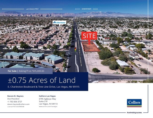
This Property Is For Sale
NEARBY LISTINGS FOR SALE OR LEASE
Property Detail
6050 Charleston Blvd
Las Vegas-Henderson-Paradise, NV
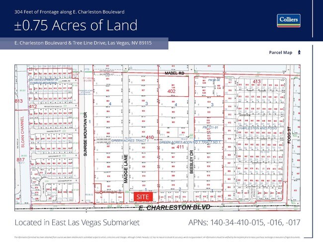
Green Acres Tract #1
140-34-410-015
GREEN ACRES TRACT #1 PLAT BOOK 4 PAGE 41 PT LOT 4 BLOCK 1
Vacantlandnec
Clark
X
Nevada
32003C2195F
4
2025
0.18 AC
2025
North Las Vegas
000515
Las Vegas
DEMOGRAPHICS near 6050 Charleston Blvd
1 Mile
3 Mile
5 Mile
2024 Total Population
26,627
171,255
374,225
2029 Population
27,519
178,187
390,258
Pop Growth 2024-2029
+ 3.35%
+ 4.05%
+ 4.28%
Average Age
37
37
38
2024 Total Households
8,003
54,968
125,561
HH Growth 2024-2029
+ 3.30%
+ 4.11%
+ 4.30%
Median Household Inc
$71,091
$60,351
$55,834
Avg Household Size
3.20
3.00
2.90
2024 Avg HH Vehicles
2.00
2.00
2.00
Median Home Value
$366,958
$334,733
$319,163
Median Year Built
1991
1990
1986
Nearby Places
- Restaurants
- Banks
- Shops
- Fitness
- Groceries
PUBLIC TRANSPORTATION
AIRPORT
Harry Reid International
DRIVE
WALK
Distance
Harry Reid International
19 min
12.1 mi
Boulder City Municipal
DRIVE
WALK
Distance
Boulder City Municipal
34 min
25.6 mi
Freight Ports
Port of Long Beach
DRIVE
WALK
Distance
Port of Long Beach
325 min
290.4 mi
Nearby Properties
Address
Land Use
TOTAL SIZE
Lot Size
Zoning
Address
Land Use
TOTAL SIZE
Lot Size
Zoning
3,356 SF
336.99 AC
RE
Address
Land Use
TOTAL SIZE
Lot Size
Zoning
35.95 AC
PF
Address
Land Use
TOTAL SIZE
Lot Size
Zoning
137.65 AC
Address
Land Use
TOTAL SIZE
Lot Size
Zoning
15.95 AC
PF
Address
Land Use
TOTAL SIZE
Lot Size
Zoning
43.25 AC
PF
Address
Land Use
TOTAL SIZE
Lot Size
Zoning
20.91 AC
PF
Address
Land Use
TOTAL SIZE
Lot Size
Zoning
9.37 AC
RE
Address
Land Use
TOTAL SIZE
Lot Size
Zoning
1,008 SF
31.47 AC
PF
Address
Land Use
TOTAL SIZE
Lot Size
Zoning
4.34 AC
RE
Address
Land Use
TOTAL SIZE
Lot Size
Zoning
19.30 AC
RE
Address
Land Use
TOTAL SIZE
Lot Size
Zoning
7,908 SF
24.13 AC
R4
Address
Land Use
TOTAL SIZE
Lot Size
Zoning
223,422 SF
18.21 AC
R3
Address
Land Use
TOTAL SIZE
Lot Size
Zoning
9,044 SF
8.62 AC
Address
Land Use
TOTAL SIZE
Lot Size
Zoning
3,183 SF
18.35 AC
R3
Address
Land Use
TOTAL SIZE
Lot Size
Zoning
3,424 SF
14.53 AC
R3
Address
Land Use
TOTAL SIZE
Lot Size
Zoning
9.11 AC
PF
Address
Land Use
TOTAL SIZE
Lot Size
Zoning
11.81 AC
RE
Address
Land Use
TOTAL SIZE
Lot Size
Zoning
4,236 SF
0.61 AC
R4
Address
Land Use
TOTAL SIZE
Lot Size
Zoning
5,425 SF
14.38 AC
C:R-4
Address
Land Use
TOTAL SIZE
Lot Size
Zoning
13.84 AC
PF
Address
Land Use
TOTAL SIZE
Lot Size
Zoning
3,886 SF
14.26 AC
R4
Address
Land Use
TOTAL SIZE
Lot Size
Zoning
216,643 SF
17.62 AC
C1
Address
Land Use
TOTAL SIZE
Lot Size
Zoning
3,632 SF
12.64 AC
RPD18
Address
Land Use
TOTAL SIZE
Lot Size
Zoning
20 AC
PF
Address
Land Use
TOTAL SIZE
Lot Size
Zoning
33,009 SF
16.84 AC
PF
Address
Land Use
TOTAL SIZE
Lot Size
Zoning
3,260 SF
0.04 AC
Address
Land Use
TOTAL SIZE
Lot Size
Zoning
5,478 SF
8.87 AC
R4
Address
Land Use
TOTAL SIZE
Lot Size
Zoning
36.52 AC
PF
Address
Land Use
TOTAL SIZE
Lot Size
Zoning
11.74 AC
PF
Address
Land Use
TOTAL SIZE
Lot Size
Zoning
2,304 SF
12.36 AC
RPD16
The World's #1 Commercial Real Estate Marketplace
Connect with us
© 2025 CoStar Group
The information above has been obtained from sources believed reliable. While we do not doubt its accuracy we have not verified it and make no guarantee, warranty or representation about it. It is your responsibility to independently confirm its accuracy and completeness. Any projections, opinions, assumptions, or estimates used are for example only and do not represent the current or future performance of the property. The value of this transaction to you depends on tax and other factors which should be evaluated by your tax, financial, and legal advisors. You and your advisors should conduct a careful, independent investigation of the property to determine to your satisfaction the suitability of the property for your needs.