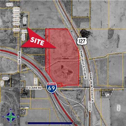
Property Record
E Clark Rd, Bath, MI 48808
Property Detail
E Clark Rd
050-014-300-020-00
E 1/8 OF W 1/2 OF SW 1/4 SEC 14 T5NR2W EXC THAT PART LYING SW OF A LN 150 FT NEOF MEAS AT RIGHT ANGLE & PARLL W/SURVEY LN OF
Miscellaneous
CLINTON
A
Michigan
A Areas with a 1% annual chance of flooding and a 26% chance of flooding over the life of a 30-year mortgage.
31.20 AC
0
Outlying Clinton County
2025
West Michigan
011101
Lansing-East Lansing, MI
NEARBY LISTINGS FOR SALE OR LEASE
-
-
-
-
-
No Photo
-
View all Bath listings for sale on LoopNet.com
DEMOGRAPHICS near E Clark Rd
1 mile
3 mile
5 mile
2025 Total Population
298
12,804
59,072
2030 Population
302
12,993
60,154
Pop Growth 2025-2030
+ 1.34%
+ 1.48%
+ 1.83%
Average Age
47
43
39
2025 Total Households
120
5,232
25,237
HH Growth 2025-2030
+ 1.67%
+ 1.45%
+ 2.01%
Median Household Inc
$103,750
$98,978
$75,401
Avg Household Size
2.30
2.40
2.30
2025 Avg HH Vehicles
2.00
2.00
2.00
Median Home Value
$260,714
$282,341
$254,702
Median Year Built
1969
1988
1982
Nearby Places
Map Layers
Map Styles
 Street
 Aerial
Transit
 Traffic
 Biking
Places
Listings with unknown addresses are not visible on the map
- Restaurants
- Banks
- Shops
- Fitness
- Groceries
PUBLIC TRANSPORTATION
AIRPORT
Capital Region International
Drive
Walk
Distance
Capital Region International
16 min
7.5 mi
Freight Ports
Port of Toledo
Drive
Walk
Distance
Port of Toledo
155 min
121.5 mi
Nearby Properties
Address
Land Use
TOTAL SIZE
Lot Size
Zoning
Address
Land Use
TOTAL SIZE
Lot Size
Zoning
142,152 SF
47.56 AC
B4
Address
Land Use
TOTAL SIZE
Lot Size
Zoning
8,834 SF
17.46 AC
DEVELOPMEN
Address
Land Use
TOTAL SIZE
Lot Size
Zoning
5,180 SF
16.94 AC
M2
Address
Land Use
TOTAL SIZE
Lot Size
Zoning
2,092 SF
152.25 AC
MHP
Address
Land Use
TOTAL SIZE
Lot Size
Zoning
7,910 SF
255.52 AC
MDR
Address
Land Use
TOTAL SIZE
Lot Size
Zoning
8,270 SF
13.15 AC
M3
Address
Land Use
TOTAL SIZE
Lot Size
Zoning
20,000 SF
25.53 AC
BC
Address
Land Use
TOTAL SIZE
Lot Size
Zoning
4,590 SF
69.64 AC
MHP
Address
Land Use
TOTAL SIZE
Lot Size
Zoning
7,910 SF
255.52 AC
MDR
Address
Land Use
TOTAL SIZE
Lot Size
Zoning
14,276 SF
6.42 AC
M3
Address
Land Use
TOTAL SIZE
Lot Size
Zoning
207,565 SF
11.50 AC
BC
Address
Land Use
TOTAL SIZE
Lot Size
Zoning
10,992 SF
10.43 AC
M3
Address
Land Use
TOTAL SIZE
Lot Size
Zoning
86,211 SF
32.56 AC
BC
Address
Land Use
TOTAL SIZE
Lot Size
Zoning
58.89 AC
B4
Address
Land Use
TOTAL SIZE
Lot Size
Zoning
39,372 SF
5.86 AC
BSC
Address
Land Use
TOTAL SIZE
Lot Size
Zoning
6,041 SF
A
Address
Land Use
TOTAL SIZE
Lot Size
Zoning
30.54 AC
B4
Address
Land Use
TOTAL SIZE
Lot Size
Zoning
1,536 SF
8.75 AC
IL
Address
Land Use
TOTAL SIZE
Lot Size
Zoning
21,453 SF
3.10 AC
B4
Address
Land Use
TOTAL SIZE
Lot Size
Zoning
24.27 AC
B4
Address
Land Use
TOTAL SIZE
Lot Size
Zoning
15,000 SF
44.67 AC
A/BC
Address
Land Use
TOTAL SIZE
Lot Size
Zoning
1,000 SF
236.70 AC
A
Address
Land Use
TOTAL SIZE
Lot Size
Zoning
17,490 SF
3.48 AC
BC
Address
Land Use
TOTAL SIZE
Lot Size
Zoning
22,413 SF
3.32 AC
M4
Address
Land Use
TOTAL SIZE
Lot Size
Zoning
5,536 SF
95.10 AC
PQ
Address
Land Use
TOTAL SIZE
Lot Size
Zoning
24,012 SF
2.31 AC
BC
Address
Land Use
TOTAL SIZE
Lot Size
Zoning
2,640 SF
7.20 AC
BC
Address
Land Use
TOTAL SIZE
Lot Size
Zoning
10,866 SF
139.75 AC
R1
Address
Land Use
TOTAL SIZE
Lot Size
Zoning
3,900 SF
2.75 AC
BC
Address
Land Use
TOTAL SIZE
Lot Size
Zoning
12,915 SF
0.95 AC
BL
The World's #1 Commercial Real Estate Marketplace
Connect with us
© 2026 CoStar Group
The information above has been obtained from sources believed reliable. While we do not doubt its accuracy we have not verified it and make no guarantee, warranty or representation about it. It is your responsibility to independently confirm its accuracy and completeness. Any projections, opinions, assumptions, or estimates used are for example only and do not represent the current or future performance of the property. The value of this transaction to you depends on tax and other factors which should be evaluated by your tax, financial, and legal advisors. You and your advisors should conduct a careful, independent investigation of the property to determine to your satisfaction the suitability of the property for your needs.