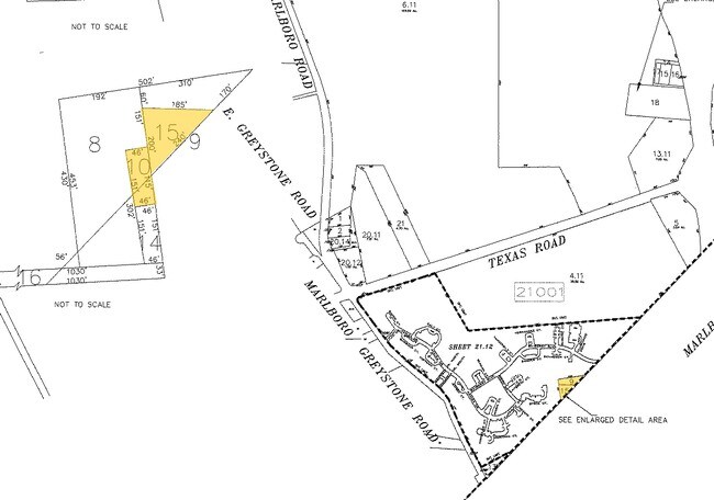
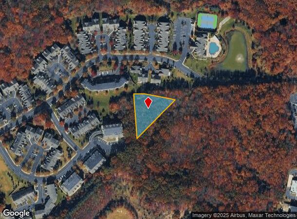
Property Record
E Greystone Rd, Old Bridge, NJ 08857
NEARBY LISTINGS FOR SALE OR LEASE
Property Detail
E Greystone Rd
15-21001-0000-00009
1.21AC
Vacantlandnec
Middlesex
X
New Jersey
34023C0281F
9
2024
1.21 AC
2025
Brunswick
007805
Northern New Jersey
7,702 SF
New York-Jersey City-White Plains, NY-NJ
DEMOGRAPHICS near E Greystone Rd
1 Mile
3 Mile
5 Mile
2024 Total Population
1,767
49,032
139,644
2029 Population
1,785
48,805
138,804
Pop Growth 2024-2029
+ 1.02%
(0.46%)
(0.60%)
Average Age
42
44
43
2024 Total Households
675
18,291
49,331
HH Growth 2024-2029
+ 0.89%
(0.52%)
(0.66%)
Median Household Inc
$140,999
$105,690
$119,766
Avg Household Size
2.60
2.60
2.80
2024 Avg HH Vehicles
2.00
2.00
2.00
Median Home Value
$608,471
$458,163
$486,754
Median Year Built
2003
1979
1980
Nearby Places
Map Layers
Map Styles
 Street
 Aerial
- Restaurants
- Banks
- Shops
- Fitness
- Groceries
PUBLIC TRANSPORTATION
COMMUTER RAIL
Aberdeen Matawan (North Jersey Coast Line - NJ Transit Commuter Rail (NJ Transit))
DRIVE
WALK
Distance
Aberdeen Matawan (North Jersey Coast Line - NJ Transit Commuter Rail (NJ Transit))
14 min
8.1 mi
Hazlet (North Jersey Coast Line - NJ Transit Commuter Rail (NJ Transit))
DRIVE
WALK
Distance
Hazlet (North Jersey Coast Line - NJ Transit Commuter Rail (NJ Transit))
18 min
9.2 mi
AIRPORT
Trenton Mercer
DRIVE
WALK
Distance
Trenton Mercer
52 min
33.4 mi
Newark Liberty International
DRIVE
WALK
Distance
Newark Liberty International
42 min
34.1 mi
Freight Ports
New York Container Terminal
DRIVE
WALK
Distance
New York Container Terminal
35 min
26.3 mi
Nearby Properties
Address
Land Use
TOTAL SIZE
Lot Size
Zoning
Address
Land Use
TOTAL SIZE
Lot Size
Zoning
212,031 SF
23.97 AC
C3
Address
Land Use
TOTAL SIZE
Lot Size
Zoning
223,463 SF
41.75 AC
C-3
Address
Land Use
TOTAL SIZE
Lot Size
Zoning
0.17 AC
R15
Address
Land Use
TOTAL SIZE
Lot Size
Zoning
7,902 SF
47.49 AC
TCD
Address
Land Use
TOTAL SIZE
Lot Size
Zoning
12,614 SF
32.36 AC
IOR
Address
Land Use
TOTAL SIZE
Lot Size
Zoning
144,977 SF
31.77 AC
C-4
Address
Land Use
TOTAL SIZE
Lot Size
Zoning
7,804 SF
12.82 AC
OG3
Address
Land Use
TOTAL SIZE
Lot Size
Zoning
9.95 AC
Address
Land Use
TOTAL SIZE
Lot Size
Zoning
30.80 AC
CF
Address
Land Use
TOTAL SIZE
Lot Size
Zoning
7,804 SF
6.71 AC
OG1
Address
Land Use
TOTAL SIZE
Lot Size
Zoning
58,674 SF
44 SF
C-3
Address
Land Use
TOTAL SIZE
Lot Size
Zoning
10.86 AC
C-3
Address
Land Use
TOTAL SIZE
Lot Size
Zoning
134,850 SF
21.78 AC
C-4
Address
Land Use
TOTAL SIZE
Lot Size
Zoning
13.82 AC
R120
Address
Land Use
TOTAL SIZE
Lot Size
Zoning
98,000 SF
7.52 AC
7663
Address
Land Use
TOTAL SIZE
Lot Size
Zoning
7,702 SF
23 AC
AF
Address
Land Use
TOTAL SIZE
Lot Size
Zoning
0.90 AC
R-1
Address
Land Use
TOTAL SIZE
Lot Size
Zoning
32.37 AC
CF
Address
Land Use
TOTAL SIZE
Lot Size
Zoning
Address
Land Use
TOTAL SIZE
Lot Size
Zoning
7,702 SF
20.75 AC
AF
Address
Land Use
TOTAL SIZE
Lot Size
Zoning
2.62 AC
OB10
Address
Land Use
TOTAL SIZE
Lot Size
Zoning
29,200 SF
7.48 AC
C-3
Address
Land Use
TOTAL SIZE
Lot Size
Zoning
750 SF
280.39 AC
SD5
Address
Land Use
TOTAL SIZE
Lot Size
Zoning
7,804 SF
15.74 AC
OG3
Address
Land Use
TOTAL SIZE
Lot Size
Zoning
7,902 SF
4.99 AC
AR
Address
Land Use
TOTAL SIZE
Lot Size
Zoning
7,702 SF
44.30 AC
R120
Address
Land Use
TOTAL SIZE
Lot Size
Zoning
0.68 AC
OG3
Address
Land Use
TOTAL SIZE
Lot Size
Zoning
36,746 SF
7.54 AC
OPT2
Address
Land Use
TOTAL SIZE
Lot Size
Zoning
Address
Land Use
TOTAL SIZE
Lot Size
Zoning
82,669 SF
3.25 AC
C-3
The World's #1 Commercial Real Estate Marketplace
Connect with us
© 2025 CoStar Group
The information above has been obtained from sources believed reliable. While we do not doubt its accuracy we have not verified it and make no guarantee, warranty or representation about it. It is your responsibility to independently confirm its accuracy and completeness. Any projections, opinions, assumptions, or estimates used are for example only and do not represent the current or future performance of the property. The value of this transaction to you depends on tax and other factors which should be evaluated by your tax, financial, and legal advisors. You and your advisors should conduct a careful, independent investigation of the property to determine to your satisfaction the suitability of the property for your needs.