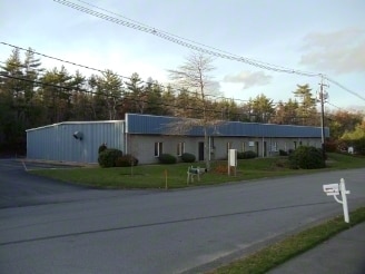
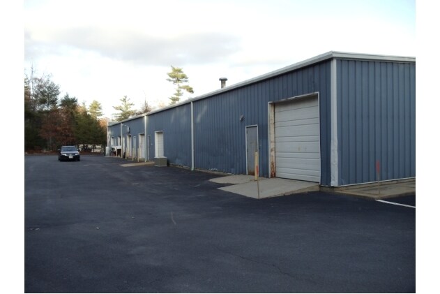
Property Record
E Grove St, Middleboro, MA 02346
NEARBY LISTINGS FOR SALE OR LEASE
Property Detail
E Grove St
MIDD M:00072 L:2616 U:0000
Plymouth
Vacantlandnec
Massachusetts
A
2616
25023C0432K
103.32 AC
2025
Route 3 South
2025
Boston
542301
Boston-Cambridge-Newton, MA-NH
3,460 SF
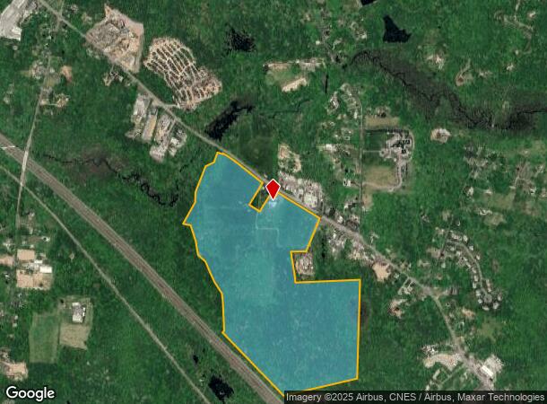
DEMOGRAPHICS near E Grove St
1 Mile
3 Mile
5 Mile
2024 Total Population
1,291
14,033
28,533
2029 Population
1,296
14,035
28,666
Pop Growth 2024-2029
+ 0.39%
+ 0.01%
+ 0.47%
Average Age
43
41
42
2024 Total Households
456
5,422
10,802
HH Growth 2024-2029
+ 0.44%
(0.04%)
+ 0.39%
Median Household Inc
$91,406
$82,674
$86,909
Avg Household Size
2.70
2.50
2.60
2024 Avg HH Vehicles
2.00
2.00
2.00
Median Home Value
$395,108
$411,186
$420,244
Median Year Built
1976
1970
1975
Nearby Places
Map Layers
Map Styles
 Street
 Aerial
- Restaurants
- Banks
- Shops
- Fitness
- Groceries
PUBLIC TRANSPORTATION
COMMUTER RAIL
Middleborough/Lakeville (Middleborough/Lakeville Line - Massachusetts Bay Transportation Authority Commuter Rail (Purple Line))
DRIVE
WALK
Distance
Middleborough/Lakeville (Middleborough/Lakeville Line - Massachusetts Bay Transportation Authority Commuter Rail (Purple Line))
6 min
3.4 mi
Freight Ports
Port of New Bedford Harbor
DRIVE
WALK
Distance
Port of New Bedford Harbor
35 min
26.7 mi
Nearby Properties
Address
Land Use
TOTAL SIZE
Lot Size
Zoning
Address
Land Use
TOTAL SIZE
Lot Size
Zoning
167,715 SF
29.54 AC
Address
Land Use
TOTAL SIZE
Lot Size
Zoning
144,454 SF
66.89 AC
Address
Land Use
TOTAL SIZE
Lot Size
Zoning
38.61 AC
Address
Land Use
TOTAL SIZE
Lot Size
Zoning
173,003 SF
26.10 AC
Address
Land Use
TOTAL SIZE
Lot Size
Zoning
2.30 AC
Address
Land Use
TOTAL SIZE
Lot Size
Zoning
7.41 AC
Address
Land Use
TOTAL SIZE
Lot Size
Zoning
48.30 AC
Address
Land Use
TOTAL SIZE
Lot Size
Zoning
130,582 SF
23.41 AC
Address
Land Use
TOTAL SIZE
Lot Size
Zoning
64,023 SF
3.48 AC
Address
Land Use
TOTAL SIZE
Lot Size
Zoning
128,922 SF
12.50 AC
Address
Land Use
TOTAL SIZE
Lot Size
Zoning
7.33 AC
Address
Land Use
TOTAL SIZE
Lot Size
Zoning
36.10 AC
Address
Land Use
TOTAL SIZE
Lot Size
Zoning
15,663 SF
8.50 AC
Address
Land Use
TOTAL SIZE
Lot Size
Zoning
10,779 SF
1.53 AC
Address
Land Use
TOTAL SIZE
Lot Size
Zoning
5,792 SF
22.04 AC
Address
Land Use
TOTAL SIZE
Lot Size
Zoning
3.05 AC
Address
Land Use
TOTAL SIZE
Lot Size
Zoning
2.68 AC
Address
Land Use
TOTAL SIZE
Lot Size
Zoning
38,744 SF
8.50 AC
Address
Land Use
TOTAL SIZE
Lot Size
Zoning
72,045 SF
3.12 AC
Address
Land Use
TOTAL SIZE
Lot Size
Zoning
33,870 SF
8 AC
Address
Land Use
TOTAL SIZE
Lot Size
Zoning
30,933 SF
12.67 AC
Address
Land Use
TOTAL SIZE
Lot Size
Zoning
44,379 SF
3 AC
Address
Land Use
TOTAL SIZE
Lot Size
Zoning
266 SF
1.10 AC
Address
Land Use
TOTAL SIZE
Lot Size
Zoning
36,465 SF
Address
Land Use
TOTAL SIZE
Lot Size
Zoning
54,000 SF
7 AC
Address
Land Use
TOTAL SIZE
Lot Size
Zoning
6.47 AC
Address
Land Use
TOTAL SIZE
Lot Size
Zoning
52,308 SF
1.67 AC
Address
Land Use
TOTAL SIZE
Lot Size
Zoning
19,090 SF
2.24 AC
Address
Land Use
TOTAL SIZE
Lot Size
Zoning
14.69 AC
Address
Land Use
TOTAL SIZE
Lot Size
Zoning
15,040 SF
2.71 AC
The World's #1 Commercial Real Estate Marketplace
Connect with us
© 2025 CoStar Group
The information above has been obtained from sources believed reliable. While we do not doubt its accuracy we have not verified it and make no guarantee, warranty or representation about it. It is your responsibility to independently confirm its accuracy and completeness. Any projections, opinions, assumptions, or estimates used are for example only and do not represent the current or future performance of the property. The value of this transaction to you depends on tax and other factors which should be evaluated by your tax, financial, and legal advisors. You and your advisors should conduct a careful, independent investigation of the property to determine to your satisfaction the suitability of the property for your needs.