Property Record
E Hampton St, Laurens, SC 29360

Property Detail
E Hampton St
906-12-04-066
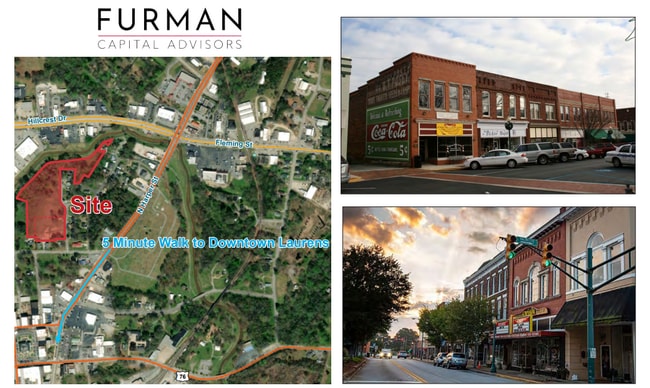
106 HAMPTON AVENUE
Vacantlandnec
LAURENS
LA
South Carolina
B and X Area of moderate flood hazard, usually the area between the limits of the 100-year and 500-year floods.
1.43 AC
2025
Laurens County
2025
Greenville/Spartanburg
920400
Greenville-Anderson-Greer, SC
NEARBY LISTINGS FOR SALE OR LEASE
DEMOGRAPHICS near E Hampton St
1 mile
3 mile
5 mile
2025 Total Population
3,843
13,953
17,763
2030 Population
4,025
14,506
18,461
Pop Growth 2025-2030
+ 4.74%
+ 3.96%
+ 3.93%
Average Age
40
41
41
2025 Total Households
1,591
5,592
7,106
HH Growth 2025-2030
+ 4.84%
+ 4.17%
+ 4.17%
Median Household Inc
$47,125
$52,034
$54,334
Avg Household Size
2.30
2.40
2.40
2025 Avg HH Vehicles
2.00
2.00
2.00
Median Home Value
$89,534
$137,049
$149,260
Median Year Built
1976
1977
1979
Nearby Places
Map Layers
Map Styles
 Street
 Aerial
Layers
 Traffic
 Biking
Places
Listings with unknown addresses are not visible on the map
- Restaurants
- Banks
- Shops
- Fitness
- Groceries
PUBLIC TRANSPORTATION
AIRPORT
Greenville Spartanburg International
Drive
Walk
Distance
Greenville Spartanburg International
52 min
39.2 mi
Freight Ports
North Charleston Terminal
Drive
Walk
Distance
North Charleston Terminal
195 min
171.5 mi
SALE & LEASE HISTORY
LISTING DATE
SALE/LEASE

Apr 12, 2023
For Sale
Nearby Properties
Address
Land Use
TOTAL SIZE
Lot Size
Zoning
Address
Land Use
TOTAL SIZE
Lot Size
Zoning
47.02 AC
LA
Address
Land Use
TOTAL SIZE
Lot Size
Zoning
10 AC
LA
Address
Land Use
TOTAL SIZE
Lot Size
Zoning
0.61 AC
Address
Land Use
TOTAL SIZE
Lot Size
Zoning
4.14 AC
LA
Address
Land Use
TOTAL SIZE
Lot Size
Zoning
10.27 AC
LA
Address
Land Use
TOTAL SIZE
Lot Size
Zoning
6.20 AC
LA
Address
Land Use
TOTAL SIZE
Lot Size
Zoning
3.02 AC
LA
Address
Land Use
TOTAL SIZE
Lot Size
Zoning
1.94 AC
LA
Address
Land Use
TOTAL SIZE
Lot Size
Zoning
0.77 AC
LA
Address
Land Use
TOTAL SIZE
Lot Size
Zoning
6.22 AC
LA
Address
Land Use
TOTAL SIZE
Lot Size
Zoning
26.68 AC
LA
Address
Land Use
TOTAL SIZE
Lot Size
Zoning
8.47 AC
LA
Address
Land Use
TOTAL SIZE
Lot Size
Zoning
0.78 AC
LA
Address
Land Use
TOTAL SIZE
Lot Size
Zoning
7.48 AC
LA
Address
Land Use
TOTAL SIZE
Lot Size
Zoning
2.36 AC
LA
Address
Land Use
TOTAL SIZE
Lot Size
Zoning
0.24 AC
LA
Address
Land Use
TOTAL SIZE
Lot Size
Zoning
Address
Land Use
TOTAL SIZE
Lot Size
Zoning
Address
Land Use
TOTAL SIZE
Lot Size
Zoning
1.96 AC
LA
Address
Land Use
TOTAL SIZE
Lot Size
Zoning
2.15 AC
LA
Address
Land Use
TOTAL SIZE
Lot Size
Zoning
2.51 AC
The World's #1 Commercial Real Estate Marketplace
Connect with us
© 2026 CoStar Group
The information above has been obtained from sources believed reliable. While we do not doubt its accuracy we have not verified it and make no guarantee, warranty or representation about it. It is your responsibility to independently confirm its accuracy and completeness. Any projections, opinions, assumptions, or estimates used are for example only and do not represent the current or future performance of the property. The value of this transaction to you depends on tax and other factors which should be evaluated by your tax, financial, and legal advisors. You and your advisors should conduct a careful, independent investigation of the property to determine to your satisfaction the suitability of the property for your needs.