Property Record
W Barnhart Rd, Poplar Bluff, MO 63901

Current Lease Availabilities
NEARBY LISTINGS FOR SALE OR LEASE
-
-
View all Poplar Bluff listings for lease on LoopNet.com
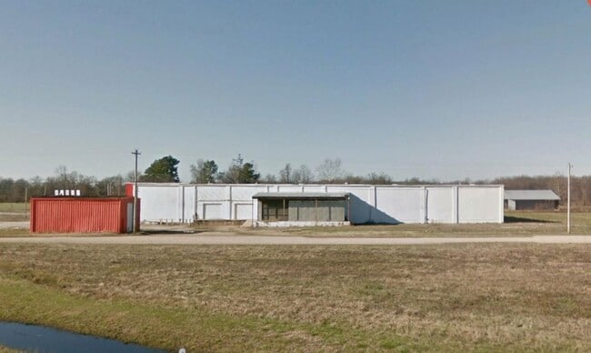
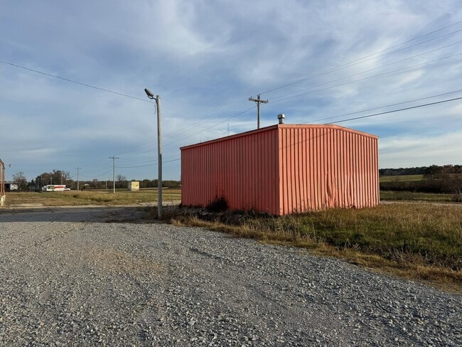
Property Detail
W Barnhart Rd
109-08-07-35-0-000-000-012-000
PT SE1/4 SE1/4: BEG SE COR: N 740.5: W 386.85: S 7 40.5: E 386.85: EX ST HWY:
Publicstorage
Butler
AE
Missouri
29023C0213E
4.94 AC
2024
Missouri South Area
2024
Other Market Areas
950302
Poplar Bluff, MO
44,727 SF
DEMOGRAPHICS near W Barnhart Rd
1 Mile
3 Mile
5 Mile
2024 Total Population
1,328
16,707
22,549
2029 Population
1,340
16,718
22,522
Pop Growth 2024-2029
+ 0.90%
+ 0.07%
(0.12%)
Average Age
40
39
40
2024 Total Households
583
6,917
9,236
HH Growth 2024-2029
+ 0.86%
+ 0.07%
(0.13%)
Median Household Inc
$20,937
$34,694
$40,771
Avg Household Size
2.10
2.30
2.30
2024 Avg HH Vehicles
1.00
1.00
2.00
Median Home Value
$71,428
$96,221
$111,827
Median Year Built
1965
1974
1976
Nearby Places
Map Layers
Map Styles
 Street
 Aerial
- Restaurants
- Banks
- Shops
- Fitness
- Groceries
PUBLIC TRANSPORTATION
COMMUTER RAIL
Poplar Bluff Amtrak Station (Texas Eagle - Amtrak)
DRIVE
WALK
Distance
Poplar Bluff Amtrak Station (Texas Eagle - Amtrak)
4 min
1.6 mi
Freight Ports
Tulsa Port of Inola
DRIVE
WALK
Distance
Tulsa Port of Inola
409 min
358.5 mi
Nearby Properties
Address
Land Use
TOTAL SIZE
Lot Size
Zoning
Address
Land Use
TOTAL SIZE
Lot Size
Zoning
4.53 AC
Address
Land Use
TOTAL SIZE
Lot Size
Zoning
28,537 SF
29.88 AC
Address
Land Use
TOTAL SIZE
Lot Size
Zoning
138,085 SF
13.50 AC
Address
Land Use
TOTAL SIZE
Lot Size
Zoning
34,740 SF
6.87 AC
Address
Land Use
TOTAL SIZE
Lot Size
Zoning
30.60 AC
Address
Land Use
TOTAL SIZE
Lot Size
Zoning
71,641 SF
0.98 AC
Address
Land Use
TOTAL SIZE
Lot Size
Zoning
223,315 SF
28.61 AC
Address
Land Use
TOTAL SIZE
Lot Size
Zoning
Address
Land Use
TOTAL SIZE
Lot Size
Zoning
Address
Land Use
TOTAL SIZE
Lot Size
Zoning
Address
Land Use
TOTAL SIZE
Lot Size
Zoning
101,306 SF
17.93 AC
Address
Land Use
TOTAL SIZE
Lot Size
Zoning
36,228 SF
1.01 AC
Address
Land Use
TOTAL SIZE
Lot Size
Zoning
49,592 SF
15.90 AC
Address
Land Use
TOTAL SIZE
Lot Size
Zoning
4,050 SF
9.98 AC
Address
Land Use
TOTAL SIZE
Lot Size
Zoning
38,006 SF
10.84 AC
Address
Land Use
TOTAL SIZE
Lot Size
Zoning
6,870 SF
0.19 AC
Address
Land Use
TOTAL SIZE
Lot Size
Zoning
18,084 SF
2.79 AC
Address
Land Use
TOTAL SIZE
Lot Size
Zoning
41,503 SF
9.60 AC
Address
Land Use
TOTAL SIZE
Lot Size
Zoning
50,792 SF
4.57 AC
Address
Land Use
TOTAL SIZE
Lot Size
Zoning
29,838 SF
2.51 AC
Address
Land Use
TOTAL SIZE
Lot Size
Zoning
61,025 SF
2.72 AC
Address
Land Use
TOTAL SIZE
Lot Size
Zoning
12,991 SF
2.16 AC
Address
Land Use
TOTAL SIZE
Lot Size
Zoning
1,561 SF
2.18 AC
Address
Land Use
TOTAL SIZE
Lot Size
Zoning
55,579 SF
6.60 AC
Address
Land Use
TOTAL SIZE
Lot Size
Zoning
520 SF
14.97 AC
Address
Land Use
TOTAL SIZE
Lot Size
Zoning
30,576 SF
8.82 AC
Address
Land Use
TOTAL SIZE
Lot Size
Zoning
18,329 SF
2.63 AC
Address
Land Use
TOTAL SIZE
Lot Size
Zoning
23,447 SF
18.81 AC
Address
Land Use
TOTAL SIZE
Lot Size
Zoning
7,261 SF
2.10 AC
Address
Land Use
TOTAL SIZE
Lot Size
Zoning
18,830 SF
5.07 AC
The World's #1 Commercial Real Estate Marketplace
Connect with us
© 2026 CoStar Group
The information above has been obtained from sources believed reliable. While we do not doubt its accuracy we have not verified it and make no guarantee, warranty or representation about it. It is your responsibility to independently confirm its accuracy and completeness. Any projections, opinions, assumptions, or estimates used are for example only and do not represent the current or future performance of the property. The value of this transaction to you depends on tax and other factors which should be evaluated by your tax, financial, and legal advisors. You and your advisors should conduct a careful, independent investigation of the property to determine to your satisfaction the suitability of the property for your needs.