Property Record
E Hightower Trl Ne, Conyers, GA 30012
NEARBY LISTINGS FOR SALE OR LEASE
-
-
View all Conyers listings for sale on LoopNet.com
Property Detail
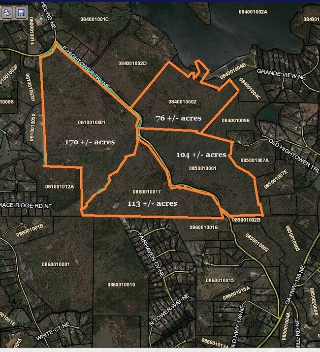
E Hightower Trl Ne
Atlanta-Sandy Springs-Roswell, GA
Rural
086-0-01-0017
EAST HIGHTOWER TRL
Privatepreserveopenspacevacantlandforestlandconservation
Rockdale
X
Georgia
13247C0105D
113 AC
2025
I-20 East/Conyers
2025
Atlanta
060101
DEMOGRAPHICS near E Hightower Trl Ne
1 mile
3 mile
5 mile
2024 Total Population
378
8,126
39,187
2029 Population
398
8,535
41,734
Pop Growth 2024-2029
+ 5.29%
+ 5.03%
+ 6.50%
Average Age
46
41
39
2024 Total Households
147
2,904
13,451
HH Growth 2024-2029
+ 5.44%
+ 5.03%
+ 6.53%
Median Household Inc
$71,999
$79,010
$70,567
Avg Household Size
2.50
2.70
2.80
2024 Avg HH Vehicles
3.00
2.00
2.00
Median Home Value
$332,692
$247,375
$226,856
Median Year Built
1991
1991
1993
Nearby Places
Map Layers
Map Styles
 Street
 Aerial
Transit
 Traffic
 Biking
Places
Listings with unknown addresses are not visible on the map
- Restaurants
- Banks
- Shops
- Fitness
- Groceries
PUBLIC TRANSPORTATION
AIRPORT
Hartsfield - Jackson Atlanta International
Drive
Walk
Distance
Hartsfield - Jackson Atlanta International
51 min
35.8 mi
Freight Ports
Georgia Ports - Savannah
Drive
Walk
Distance
Georgia Ports - Savannah
288 min
244.7 mi
SALE & LEASE HISTORY
LISTING DATE
SALE/LEASE

Aug 17, 2022
For Sale
Nearby Properties
Address
Land Use
TOTAL SIZE
Lot Size
Zoning
Address
Land Use
TOTAL SIZE
Lot Size
Zoning
362,852 SF
18.42 AC
RM24
Address
Land Use
TOTAL SIZE
Lot Size
Zoning
7,806 SF
32.76 AC
RM
Address
Land Use
TOTAL SIZE
Lot Size
Zoning
286.57 AC
RES AG
Address
Land Use
TOTAL SIZE
Lot Size
Zoning
66,181 SF
25.46 AC
R1A
Address
Land Use
TOTAL SIZE
Lot Size
Zoning
7,020 SF
29.06 AC
RES AG
Address
Land Use
TOTAL SIZE
Lot Size
Zoning
11,000 SF
56.32 AC
R3/C
Address
Land Use
TOTAL SIZE
Lot Size
Zoning
653.65 AC
WP
Address
Land Use
TOTAL SIZE
Lot Size
Zoning
8,437 SF
37.62 AC
WP
Address
Land Use
TOTAL SIZE
Lot Size
Zoning
6,651 SF
17.66 AC
WP
Address
Land Use
TOTAL SIZE
Lot Size
Zoning
7,892 SF
44.53 AC
WP
Address
Land Use
TOTAL SIZE
Lot Size
Zoning
12,378 SF
4.16 AC
WP
Address
Land Use
TOTAL SIZE
Lot Size
Zoning
7,522 SF
11.10 AC
WP
Address
Land Use
TOTAL SIZE
Lot Size
Zoning
11,740 SF
2.59 AC
WP
Address
Land Use
TOTAL SIZE
Lot Size
Zoning
38.50 AC
R3C2C1OI(C
Address
Land Use
TOTAL SIZE
Lot Size
Zoning
3,792 SF
33.35 AC
AR
Address
Land Use
TOTAL SIZE
Lot Size
Zoning
10,566 SF
2.53 AC
WP
Address
Land Use
TOTAL SIZE
Lot Size
Zoning
12,249 SF
5.24 AC
WP
Address
Land Use
TOTAL SIZE
Lot Size
Zoning
6,245 SF
10 AC
WP
Address
Land Use
TOTAL SIZE
Lot Size
Zoning
6,199 SF
4.74 AC
WP
Address
Land Use
TOTAL SIZE
Lot Size
Zoning
9,851 SF
5.22 AC
WP
Address
Land Use
TOTAL SIZE
Lot Size
Zoning
8,955 SF
20.14 AC
A1
Address
Land Use
TOTAL SIZE
Lot Size
Zoning
5,941 SF
4.39 AC
WP
Address
Land Use
TOTAL SIZE
Lot Size
Zoning
13,500 SF
1.18 AC
R1
Address
Land Use
TOTAL SIZE
Lot Size
Zoning
8,433 SF
2.18 AC
C1/C
Address
Land Use
TOTAL SIZE
Lot Size
Zoning
10,493 SF
11.96 AC
R1/R1A
Address
Land Use
TOTAL SIZE
Lot Size
Zoning
4,901 SF
18.11 AC
WP
Address
Land Use
TOTAL SIZE
Lot Size
Zoning
4,985 SF
48.90 AC
AR
Address
Land Use
TOTAL SIZE
Lot Size
Zoning
7,712 SF
3.03 AC
WP
Address
Land Use
TOTAL SIZE
Lot Size
Zoning
9,670 SF
2 AC
WP
Address
Land Use
TOTAL SIZE
Lot Size
Zoning
8,777 SF
2.16 AC
WP
The World's #1 Commercial Real Estate Marketplace
Connect with us
© 2026 CoStar Group
The information above has been obtained from sources believed reliable. While we do not doubt its accuracy we have not verified it and make no guarantee, warranty or representation about it. It is your responsibility to independently confirm its accuracy and completeness. Any projections, opinions, assumptions, or estimates used are for example only and do not represent the current or future performance of the property. The value of this transaction to you depends on tax and other factors which should be evaluated by your tax, financial, and legal advisors. You and your advisors should conduct a careful, independent investigation of the property to determine to your satisfaction the suitability of the property for your needs.