Property Record
E Highway 34, Sharpsburg, GA 30277

NEARBY LISTINGS FOR SALE OR LEASE
Property Detail
E Highway 34
Atlanta-Sandy Springs-Roswell, GA
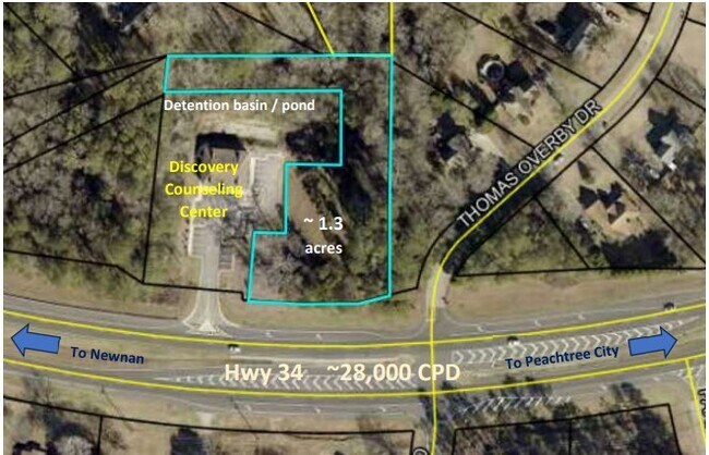
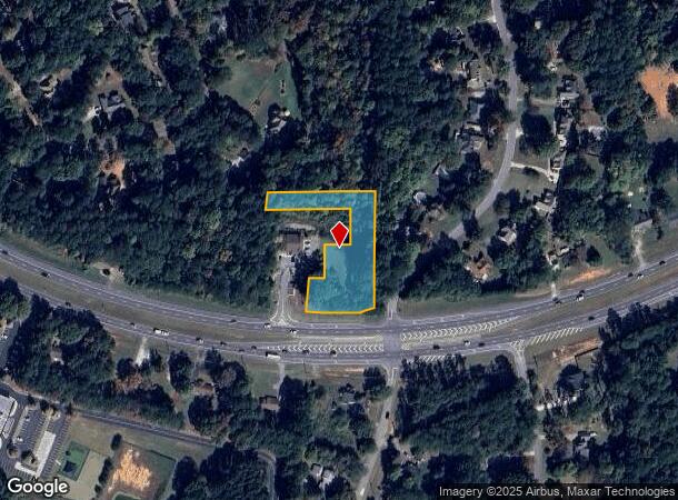
(LOT 1B) 1.310 AC LL92 6LD
133-6092-117
Coweta
Commercialnec
Georgia
X
1b
13077C0170D
1.31 AC
2025
Fayette/Coweta County
2025
Atlanta
170405
DEMOGRAPHICS near E Highway 34
1 Mile
3 Mile
5 Mile
2024 Total Population
2,707
20,409
63,689
2029 Population
3,042
22,503
69,579
Pop Growth 2024-2029
+ 12.38%
+ 10.26%
+ 9.25%
Average Age
43
41
41
2024 Total Households
979
7,231
23,507
HH Growth 2024-2029
+ 12.56%
+ 10.34%
+ 9.25%
Median Household Inc
$97,580
$111,448
$101,806
Avg Household Size
2.70
2.80
2.70
2024 Avg HH Vehicles
3.00
3.00
2.00
Median Home Value
$267,721
$296,923
$324,545
Median Year Built
1992
1994
1995
Nearby Places
Map Layers
Map Styles
 Street
 Aerial
- Restaurants
- Banks
- Shops
- Fitness
- Groceries
PUBLIC TRANSPORTATION
AIRPORT
Hartsfield - Jackson Atlanta International
DRIVE
WALK
Distance
Hartsfield - Jackson Atlanta International
37 min
28.5 mi
Freight Ports
Georgia Ports - Savannah
DRIVE
WALK
Distance
Georgia Ports - Savannah
292 min
249.7 mi
SALE & LEASE HISTORY
LISTING DATE
SALE/LEASE

Apr 16, 2024
For Lease
Nearby Properties
Address
Land Use
TOTAL SIZE
Lot Size
Zoning
Address
Land Use
TOTAL SIZE
Lot Size
Zoning
166,866 SF
85.16 AC
R1
Address
Land Use
TOTAL SIZE
Lot Size
Zoning
156,113 SF
25.37 AC
001
Address
Land Use
TOTAL SIZE
Lot Size
Zoning
117,354 SF
48.81 AC
ND
Address
Land Use
TOTAL SIZE
Lot Size
Zoning
71,888 SF
23.48 AC
R1
Address
Land Use
TOTAL SIZE
Lot Size
Zoning
47,598 SF
4.29 AC
C
Address
Land Use
TOTAL SIZE
Lot Size
Zoning
153,191 SF
20.95 AC
R1
Address
Land Use
TOTAL SIZE
Lot Size
Zoning
121,290 SF
11.74 AC
R1
Address
Land Use
TOTAL SIZE
Lot Size
Zoning
59,250 SF
8.77 AC
R1
Address
Land Use
TOTAL SIZE
Lot Size
Zoning
86,761 SF
6.35 AC
C LUC
Address
Land Use
TOTAL SIZE
Lot Size
Zoning
112,650 SF
5.70 AC
002
Address
Land Use
TOTAL SIZE
Lot Size
Zoning
137,702 SF
17.39 AC
R1
Address
Land Use
TOTAL SIZE
Lot Size
Zoning
90,474 SF
12.56 AC
C
Address
Land Use
TOTAL SIZE
Lot Size
Zoning
28,753 SF
4.83 AC
R1
Address
Land Use
TOTAL SIZE
Lot Size
Zoning
103,594 SF
18.83 AC
R1
Address
Land Use
TOTAL SIZE
Lot Size
Zoning
47,540 SF
6.33 AC
R1
Address
Land Use
TOTAL SIZE
Lot Size
Zoning
28,560 SF
10.91 AC
R1
Address
Land Use
TOTAL SIZE
Lot Size
Zoning
80,564 SF
16.23 AC
R1
Address
Land Use
TOTAL SIZE
Lot Size
Zoning
31,794 SF
2.65 AC
R1
Address
Land Use
TOTAL SIZE
Lot Size
Zoning
98,838 SF
8.18 AC
R1
Address
Land Use
TOTAL SIZE
Lot Size
Zoning
67,604 SF
29.71 AC
R1
Address
Land Use
TOTAL SIZE
Lot Size
Zoning
41,355 SF
25.21 AC
R1
Address
Land Use
TOTAL SIZE
Lot Size
Zoning
59,753 SF
8.77 AC
R1
Address
Land Use
TOTAL SIZE
Lot Size
Zoning
38,312 SF
6.90 AC
R1
Address
Land Use
TOTAL SIZE
Lot Size
Zoning
23,561 SF
11.75 AC
R1
Address
Land Use
TOTAL SIZE
Lot Size
Zoning
28,683 SF
33.64 AC
R1
Address
Land Use
TOTAL SIZE
Lot Size
Zoning
7,117 SF
2.26 AC
R1
Address
Land Use
TOTAL SIZE
Lot Size
Zoning
6,375 SF
1.62 AC
R1
Address
Land Use
TOTAL SIZE
Lot Size
Zoning
9,153 SF
1.39 AC
R1
Address
Land Use
TOTAL SIZE
Lot Size
Zoning
31,546 SF
31.32 AC
001
Address
Land Use
TOTAL SIZE
Lot Size
Zoning
26,782 SF
11.32 AC
R1
The World's #1 Commercial Real Estate Marketplace
Connect with us
© 2025 CoStar Group
The information above has been obtained from sources believed reliable. While we do not doubt its accuracy we have not verified it and make no guarantee, warranty or representation about it. It is your responsibility to independently confirm its accuracy and completeness. Any projections, opinions, assumptions, or estimates used are for example only and do not represent the current or future performance of the property. The value of this transaction to you depends on tax and other factors which should be evaluated by your tax, financial, and legal advisors. You and your advisors should conduct a careful, independent investigation of the property to determine to your satisfaction the suitability of the property for your needs.