Property Record
E Highway 80 E, Swainsboro, GA 30401
NEARBY LISTINGS FOR SALE OR LEASE
Property Detail
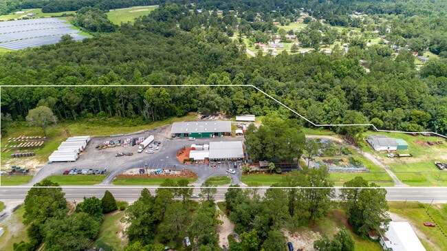
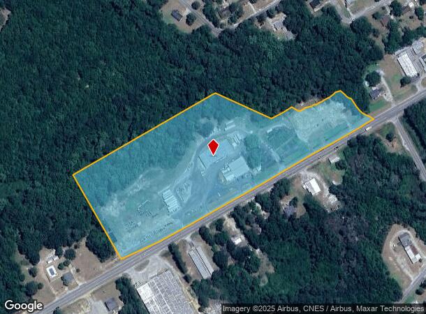
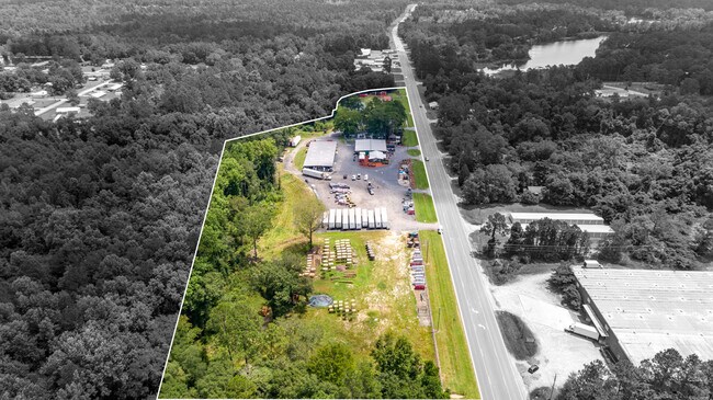
E Highway 80 E
095-058A
Comm-Hwy 80 E (Secondary)
Wholesaleoutletdiscountstore
HWY 80 E GILPIN S/D 53RD DIS
AE
Emanuel
13107C0302C
Georgia
2024
13.09 AC
2024
Georgia South Area
970401
Other Market Areas
4,857 SF
DEMOGRAPHICS near E Highway 80 E
1 mile
3 mile
5 mile
2024 Total Population
1,588
9,468
11,278
2029 Population
1,619
9,718
11,572
Pop Growth 2024-2029
+ 1.95%
+ 2.64%
+ 2.61%
Average Age
39
39
39
2024 Total Households
603
3,540
4,211
HH Growth 2024-2029
+ 2.16%
+ 2.71%
+ 2.68%
Median Household Inc
$40,869
$40,284
$41,321
Avg Household Size
2.50
2.50
2.50
2024 Avg HH Vehicles
2.00
2.00
2.00
Median Home Value
$94,474
$93,909
$91,673
Median Year Built
1980
1978
1978
Nearby Places
Map Layers
Map Styles
 Street
 Aerial
Transit
 Traffic
 Biking
Places
Listings with unknown addresses are not visible on the map
- Restaurants
- Banks
- Shops
- Fitness
- Groceries
SALE & LEASE HISTORY
LISTING DATE
SALE/LEASE

Aug 25, 2021
For Sale
Nearby Properties
Address
Land Use
TOTAL SIZE
Lot Size
Zoning
Address
Land Use
TOTAL SIZE
Lot Size
Zoning
231 AC
RURAL
Address
Land Use
TOTAL SIZE
Lot Size
Zoning
44,255 SF
60 AC
RURAL
Address
Land Use
TOTAL SIZE
Lot Size
Zoning
219.26 AC
RURAL
Address
Land Use
TOTAL SIZE
Lot Size
Zoning
156,832 SF
18.87 AC
COMMERCIAL
Address
Land Use
TOTAL SIZE
Lot Size
Zoning
1,838 SF
9.01 AC
COMMERCIAL
Address
Land Use
TOTAL SIZE
Lot Size
Zoning
548.43 AC
RESIDENTIA
Address
Land Use
TOTAL SIZE
Lot Size
Zoning
6,941 SF
7.60 AC
RESIDENTIA
Address
Land Use
TOTAL SIZE
Lot Size
Zoning
6.55 AC
RESIDENTIA
Address
Land Use
TOTAL SIZE
Lot Size
Zoning
967 SF
10 AC
COMMERCIAL
Address
Land Use
TOTAL SIZE
Lot Size
Zoning
7,396 SF
0.86 AC
RESIDENTIA
Address
Land Use
TOTAL SIZE
Lot Size
Zoning
21,231 SF
19.40 AC
RESIDENTIA
Address
Land Use
TOTAL SIZE
Lot Size
Zoning
129,304 SF
14.66 AC
INDUSTRIAL
Address
Land Use
TOTAL SIZE
Lot Size
Zoning
41,166 SF
7.76 AC
RESIDENTIA
Address
Land Use
TOTAL SIZE
Lot Size
Zoning
32,000 SF
5.91 AC
COMMERCIAL
Address
Land Use
TOTAL SIZE
Lot Size
Zoning
20.76 AC
RURAL
Address
Land Use
TOTAL SIZE
Lot Size
Zoning
13,362 SF
3.25 AC
RESIDENTIA
Address
Land Use
TOTAL SIZE
Lot Size
Zoning
5,460 SF
2.76 AC
COMMERCIAL
Address
Land Use
TOTAL SIZE
Lot Size
Zoning
134,001 SF
7.71 AC
COMMERCIAL
Address
Land Use
TOTAL SIZE
Lot Size
Zoning
33,515 SF
2.98 AC
COMMERCIAL
Address
Land Use
TOTAL SIZE
Lot Size
Zoning
17,200 SF
1.55 AC
COMMERCIAL
Address
Land Use
TOTAL SIZE
Lot Size
Zoning
43,900 SF
6.19 AC
COMMERCIAL
Address
Land Use
TOTAL SIZE
Lot Size
Zoning
29,808 SF
12.55 AC
RURAL
Address
Land Use
TOTAL SIZE
Lot Size
Zoning
7.50 AC
RURAL
Address
Land Use
TOTAL SIZE
Lot Size
Zoning
8,737 SF
1.33 AC
COMMERCIAL
Address
Land Use
TOTAL SIZE
Lot Size
Zoning
10,175 SF
1.86 AC
COMMERCIAL
Address
Land Use
TOTAL SIZE
Lot Size
Zoning
15,785 SF
12.82 AC
RESIDENTIA
Address
Land Use
TOTAL SIZE
Lot Size
Zoning
19,142 SF
4.70 AC
COMMERCIAL
Address
Land Use
TOTAL SIZE
Lot Size
Zoning
22,820 SF
2.99 AC
COMMERCIAL
Address
Land Use
TOTAL SIZE
Lot Size
Zoning
14,606 SF
1.10 AC
COMMERCIAL
Address
Land Use
TOTAL SIZE
Lot Size
Zoning
22,070 SF
1.27 AC
RESIDENTIA
The World's #1 Commercial Real Estate Marketplace
Connect with us
© 2026 CoStar Group
The information above has been obtained from sources believed reliable. While we do not doubt its accuracy we have not verified it and make no guarantee, warranty or representation about it. It is your responsibility to independently confirm its accuracy and completeness. Any projections, opinions, assumptions, or estimates used are for example only and do not represent the current or future performance of the property. The value of this transaction to you depends on tax and other factors which should be evaluated by your tax, financial, and legal advisors. You and your advisors should conduct a careful, independent investigation of the property to determine to your satisfaction the suitability of the property for your needs.