Property Record
I-20 E E E, Colorado City, TX 79512

Save to a Folder
{{folder.Name}}
{{folder.ListingIds.length}} Properties
{{folder.ListingIds.length}} Property
Create a New Folder
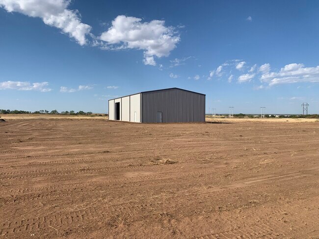
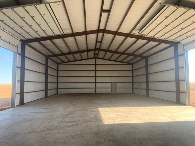
Property Detail
I-20 E E E
Other Market Areas
ABST 444 BLK 26 T&P SEC 33 19.8 ACRES
13324
MITCHELL
Residentialacreage
Texas
2025
19.80 AC
2025
Texas West Area
950200
NEARBY LISTINGS FOR SALE OR LEASE
DEMOGRAPHICS near I-20 E E E
1 mile
3 mile
5 mile
2025 Total Population
2,234
6,479
6,743
2030 Population
2,189
6,439
6,697
Pop Growth 2025-2030
(2.01%)
(0.62%)
(0.68%)
Average Age
38
38
38
2025 Total Households
707
1,694
1,799
HH Growth 2025-2030
(2.12%)
(0.59%)
(0.67%)
Median Household Inc
$52,674
$54,748
$55,971
Avg Household Size
2.50
2.50
2.50
2025 Avg HH Vehicles
2.00
2.00
2.00
Median Home Value
$91,632
$77,209
$80,547
Median Year Built
1952
1951
1952
Nearby Places
Map Layers
Map Styles
 Street
 Aerial
Layers
 Traffic
 Biking
Places
Listings with unknown addresses are not visible on the map
- Restaurants
- Banks
- Shops
- Fitness
- Groceries
SALE & LEASE HISTORY
LISTING DATE
SALE/LEASE

Nov 08, 2023
For Sale
Nearby Properties
Address
Land Use
TOTAL SIZE
Lot Size
Zoning
Address
Land Use
TOTAL SIZE
Lot Size
Zoning
158,471 SF
146.89 AC
Address
Land Use
TOTAL SIZE
Lot Size
Zoning
195,189 SF
51.48 AC
Address
Land Use
TOTAL SIZE
Lot Size
Zoning
297,520 SF
23.44 AC
Address
Land Use
TOTAL SIZE
Lot Size
Zoning
31,470 SF
2.07 AC
Address
Land Use
TOTAL SIZE
Lot Size
Zoning
31,728 SF
1.93 AC
Address
Land Use
TOTAL SIZE
Lot Size
Zoning
44,949 SF
0.84 AC
Address
Land Use
TOTAL SIZE
Lot Size
Zoning
228,180 SF
7.87 AC
Address
Land Use
TOTAL SIZE
Lot Size
Zoning
40,316 SF
2.14 AC
Address
Land Use
TOTAL SIZE
Lot Size
Zoning
59,077 SF
2.76 AC
Address
Land Use
TOTAL SIZE
Lot Size
Zoning
31,377 SF
1.93 AC
Address
Land Use
TOTAL SIZE
Lot Size
Zoning
12,186 SF
1.81 AC
Address
Land Use
TOTAL SIZE
Lot Size
Zoning
90,308 SF
2.07 AC
Address
Land Use
TOTAL SIZE
Lot Size
Zoning
120,764 SF
4.37 AC
Address
Land Use
TOTAL SIZE
Lot Size
Zoning
20,131 SF
2 AC
Address
Land Use
TOTAL SIZE
Lot Size
Zoning
80,138 SF
8.11 AC
Address
Land Use
TOTAL SIZE
Lot Size
Zoning
25,756 SF
0.48 AC
Address
Land Use
TOTAL SIZE
Lot Size
Zoning
21,834 SF
0.48 AC
Address
Land Use
TOTAL SIZE
Lot Size
Zoning
44,745 SF
3.11 AC
Address
Land Use
TOTAL SIZE
Lot Size
Zoning
24,009 SF
2.07 AC
Address
Land Use
TOTAL SIZE
Lot Size
Zoning
44,166 SF
1.36 AC
Address
Land Use
TOTAL SIZE
Lot Size
Zoning
43,858 SF
4.30 AC
Address
Land Use
TOTAL SIZE
Lot Size
Zoning
960 SF
594.85 AC
Address
Land Use
TOTAL SIZE
Lot Size
Zoning
25,464 SF
0.80 AC
Address
Land Use
TOTAL SIZE
Lot Size
Zoning
9,815 SF
23.92 AC
Address
Land Use
TOTAL SIZE
Lot Size
Zoning
13,304 SF
0.96 AC
Address
Land Use
TOTAL SIZE
Lot Size
Zoning
1,666 SF
521.58 AC
Address
Land Use
TOTAL SIZE
Lot Size
Zoning
94,529 SF
2 AC
Address
Land Use
TOTAL SIZE
Lot Size
Zoning
6,182 SF
480 AC
Address
Land Use
TOTAL SIZE
Lot Size
Zoning
27,766 SF
1.93 AC
Address
Land Use
TOTAL SIZE
Lot Size
Zoning
10,542 SF
0.48 AC
The World's #1 Commercial Real Estate Marketplace
Connect with us
© 2026 CoStar Group
The information above has been obtained from sources believed reliable. While we do not doubt its accuracy we have not verified it and make no guarantee, warranty or representation about it. It is your responsibility to independently confirm its accuracy and completeness. Any projections, opinions, assumptions, or estimates used are for example only and do not represent the current or future performance of the property. The value of this transaction to you depends on tax and other factors which should be evaluated by your tax, financial, and legal advisors. You and your advisors should conduct a careful, independent investigation of the property to determine to your satisfaction the suitability of the property for your needs.