Property Record
E Ih 20, Odessa, TX


NEARBY LISTINGS FOR SALE OR LEASE
Property Detail
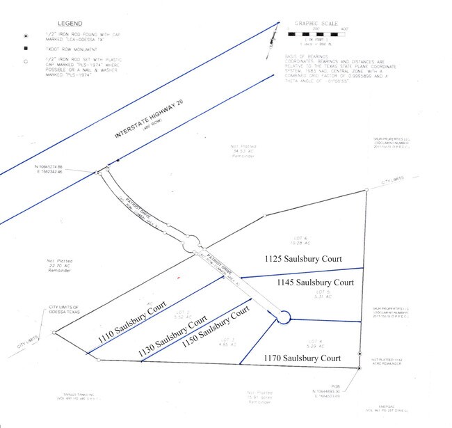
E Ih 20
42020-00020-01100
T-2-S BLK 41 SEC 30 (CARD #2) S OF I-20 OUTSIDE CITY
Agriculturalland
Ector
AE
Texas
48135C0360E
15.91 AC
2025
Midland & Odessa
2025
Other Market Areas
003000
Odessa, TX
DEMOGRAPHICS near E Ih 20
1 Mile
3 Mile
5 Mile
2024 Total Population
122
28,971
91,812
2029 Population
122
28,478
91,388
Pop Growth 2024-2029
0.00%
(1.70%)
(0.46%)
Average Age
39
35
35
2024 Total Households
42
10,618
33,753
HH Growth 2024-2029
0.00%
(1.95%)
(0.58%)
Median Household Inc
$127,500
$64,529
$60,985
Avg Household Size
2.80
2.60
2.60
2024 Avg HH Vehicles
3.00
2.00
2.00
Median Home Value
$348,148
$233,351
$181,999
Median Year Built
1964
1977
1977
Nearby Places
Map Layers
Map Styles
 Street
 Aerial
- Restaurants
- Banks
- Shops
- Fitness
- Groceries
PUBLIC TRANSPORTATION
AIRPORT
Midland International Air And Space Port
DRIVE
WALK
Distance
Midland International Air And Space Port
16 min
10.6 mi
Freight Ports
Port of Corpus Christi
DRIVE
WALK
Distance
Port of Corpus Christi
505 min
486.3 mi
SALE & LEASE HISTORY
LISTING DATE
SALE/LEASE

Nov 09, 2023
For Lease
Nearby Properties
Address
Land Use
TOTAL SIZE
Lot Size
Zoning
Address
Land Use
TOTAL SIZE
Lot Size
Zoning
23,000 SF
170.58 AC
ES2
Address
Land Use
TOTAL SIZE
Lot Size
Zoning
21,296 SF
541.62 AC
EF1
Address
Land Use
TOTAL SIZE
Lot Size
Zoning
8,000 SF
40 AC
ES2
Address
Land Use
TOTAL SIZE
Lot Size
Zoning
Address
Land Use
TOTAL SIZE
Lot Size
Zoning
426,687 SF
81.50 AC
ES2
Address
Land Use
TOTAL SIZE
Lot Size
Zoning
117,725 SF
19.23 AC
EE5
Address
Land Use
TOTAL SIZE
Lot Size
Zoning
3,336 SF
11.21 AC
EF5
Address
Land Use
TOTAL SIZE
Lot Size
Zoning
36,084 SF
18.99 AC
EF3
Address
Land Use
TOTAL SIZE
Lot Size
Zoning
2,688 SF
12.06 AC
EF5
Address
Land Use
TOTAL SIZE
Lot Size
Zoning
5,200 SF
7.16 AC
EF7
Address
Land Use
TOTAL SIZE
Lot Size
Zoning
10,644 SF
57.53 AC
Address
Land Use
TOTAL SIZE
Lot Size
Zoning
11,000 SF
72.24 AC
Address
Land Use
TOTAL SIZE
Lot Size
Zoning
2,512 SF
7.47 AC
EF7
Address
Land Use
TOTAL SIZE
Lot Size
Zoning
19,401 SF
20.70 AC
ES2
Address
Land Use
TOTAL SIZE
Lot Size
Zoning
Address
Land Use
TOTAL SIZE
Lot Size
Zoning
156,000 SF
8.68 AC
EF5
Address
Land Use
TOTAL SIZE
Lot Size
Zoning
118,336 SF
6.16 AC
EF7
Address
Land Use
TOTAL SIZE
Lot Size
Zoning
13,615 SF
22.42 AC
Address
Land Use
TOTAL SIZE
Lot Size
Zoning
1,176 SF
9.55 AC
EF5
Address
Land Use
TOTAL SIZE
Lot Size
Zoning
71,412 SF
8.63 AC
EF5
Address
Land Use
TOTAL SIZE
Lot Size
Zoning
133,778 SF
11.59 AC
EE3
Address
Land Use
TOTAL SIZE
Lot Size
Zoning
133,454 SF
25.41 AC
EE2
Address
Land Use
TOTAL SIZE
Lot Size
Zoning
14,580 SF
20.28 AC
ES2
Address
Land Use
TOTAL SIZE
Lot Size
Zoning
135,140 SF
24.04 AC
ED6
Address
Land Use
TOTAL SIZE
Lot Size
Zoning
68,377 SF
9.69 AC
ES2
Address
Land Use
TOTAL SIZE
Lot Size
Zoning
26,000 SF
24.55 AC
Address
Land Use
TOTAL SIZE
Lot Size
Zoning
138,488 SF
5.54 AC
EF7
Address
Land Use
TOTAL SIZE
Lot Size
Zoning
3,112 SF
6.46 AC
ED3
Address
Land Use
TOTAL SIZE
Lot Size
Zoning
2,100 SF
5.34 AC
EF7
Address
Land Use
TOTAL SIZE
Lot Size
Zoning
46,734 SF
10.42 AC
ES2
The World's #1 Commercial Real Estate Marketplace
Connect with us
© 2025 CoStar Group
The information above has been obtained from sources believed reliable. While we do not doubt its accuracy we have not verified it and make no guarantee, warranty or representation about it. It is your responsibility to independently confirm its accuracy and completeness. Any projections, opinions, assumptions, or estimates used are for example only and do not represent the current or future performance of the property. The value of this transaction to you depends on tax and other factors which should be evaluated by your tax, financial, and legal advisors. You and your advisors should conduct a careful, independent investigation of the property to determine to your satisfaction the suitability of the property for your needs.