Property Record
E Interstate Highway 40, Amarillo, TX

NEARBY LISTINGS FOR SALE OR LEASE
Property Detail
E Interstate Highway 40
Amarillo, TX
A B & M
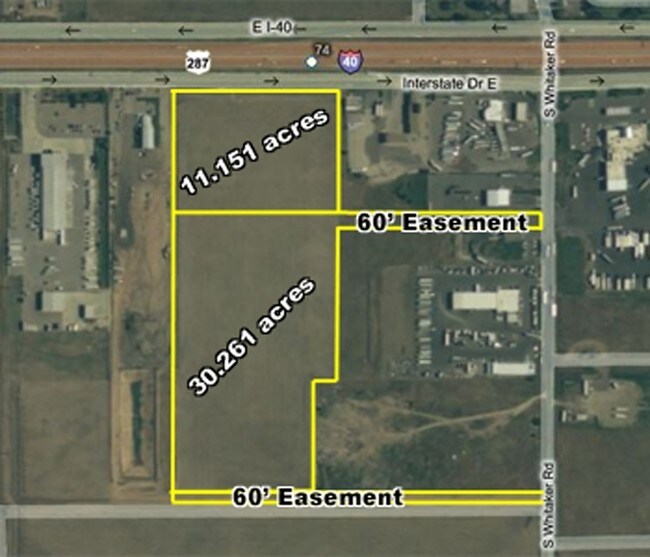
R-200-1070-2000-0
SECT 107 A B & M BLK 0002, IRREG TR BEG APPRX 60FT W & 875.5FT S OF NE COR OF SECT, 30.6900 ACRES
Commercialnec
Potter
X
Texas
48375C0534C
30.69 AC
2024
Amarillo
2025
Other Market Areas
DEMOGRAPHICS near E Interstate Highway 40
1 Mile
3 Mile
5 Mile
2024 Total Population
1,669
21,552
68,675
2029 Population
1,633
21,172
68,554
Pop Growth 2024-2029
(2.16%)
(1.76%)
(0.18%)
Average Age
34
35
35
2024 Total Households
558
7,141
22,772
HH Growth 2024-2029
(2.33%)
(1.93%)
(0.11%)
Median Household Inc
$62,062
$49,446
$43,047
Avg Household Size
2.90
2.90
2.70
2024 Avg HH Vehicles
2.00
2.00
2.00
Median Home Value
$69,963
$77,615
$83,547
Median Year Built
1964
1961
1959
Nearby Places
Map Layers
Map Styles
 Street
 Aerial
- Restaurants
- Banks
- Shops
- Fitness
- Groceries
PUBLIC TRANSPORTATION
AIRPORT
Rick Husband Amarillo International
DRIVE
WALK
Distance
Rick Husband Amarillo International
9 min
4.8 mi
Freight Ports
Tulsa Port Of Catoosa
DRIVE
WALK
Distance
Tulsa Port Of Catoosa
391 min
372.8 mi
Nearby Properties
Address
Land Use
TOTAL SIZE
Lot Size
Zoning
Address
Land Use
TOTAL SIZE
Lot Size
Zoning
414,471 SF
104.16 AC
LC
Address
Land Use
TOTAL SIZE
Lot Size
Zoning
325,220 SF
26.22 AC
PD
Address
Land Use
TOTAL SIZE
Lot Size
Zoning
89,206 SF
17.98 AC
Address
Land Use
TOTAL SIZE
Lot Size
Zoning
127,654 SF
5.73 AC
HC
Address
Land Use
TOTAL SIZE
Lot Size
Zoning
152,702 SF
46.34 AC
Address
Land Use
TOTAL SIZE
Lot Size
Zoning
69,116 SF
4.05 AC
Address
Land Use
TOTAL SIZE
Lot Size
Zoning
136,639 SF
18.07 AC
R2
Address
Land Use
TOTAL SIZE
Lot Size
Zoning
1,604 SF
419.88 AC
A
Address
Land Use
TOTAL SIZE
Lot Size
Zoning
209,957 SF
24.24 AC
LC
Address
Land Use
TOTAL SIZE
Lot Size
Zoning
43,910 SF
101.33 AC
1F2HC
Address
Land Use
TOTAL SIZE
Lot Size
Zoning
136,844 SF
38.77 AC
Address
Land Use
TOTAL SIZE
Lot Size
Zoning
181,798 SF
17.27 AC
HC
Address
Land Use
TOTAL SIZE
Lot Size
Zoning
89,740 SF
2.71 AC
Address
Land Use
TOTAL SIZE
Lot Size
Zoning
92,341 SF
9.91 AC
R3
Address
Land Use
TOTAL SIZE
Lot Size
Zoning
93,274 SF
7.16 AC
HC
Address
Land Use
TOTAL SIZE
Lot Size
Zoning
49,499 SF
2.84 AC
HC
Address
Land Use
TOTAL SIZE
Lot Size
Zoning
87,936 SF
2.89 AC
Address
Land Use
TOTAL SIZE
Lot Size
Zoning
26,152 SF
2.65 AC
GR
Address
Land Use
TOTAL SIZE
Lot Size
Zoning
74,509 SF
2.49 AC
Address
Land Use
TOTAL SIZE
Lot Size
Zoning
57,489 SF
2.48 AC
Address
Land Use
TOTAL SIZE
Lot Size
Zoning
66,756 SF
6.21 AC
Address
Land Use
TOTAL SIZE
Lot Size
Zoning
71,907 SF
8.54 AC
2F
Address
Land Use
TOTAL SIZE
Lot Size
Zoning
52,318 SF
1.78 AC
Address
Land Use
TOTAL SIZE
Lot Size
Zoning
15,448 SF
16.10 AC
Address
Land Use
TOTAL SIZE
Lot Size
Zoning
74,897 SF
7.33 AC
LC
Address
Land Use
TOTAL SIZE
Lot Size
Zoning
53,855 SF
1.88 AC
HC
Address
Land Use
TOTAL SIZE
Lot Size
Zoning
84,352 SF
21.76 AC
HC
Address
Land Use
TOTAL SIZE
Lot Size
Zoning
91,134 SF
7.33 AC
LC
Address
Land Use
TOTAL SIZE
Lot Size
Zoning
58,776 SF
6.39 AC
HC
Address
Land Use
TOTAL SIZE
Lot Size
Zoning
57,981 SF
9.55 AC
R3
The World's #1 Commercial Real Estate Marketplace
Connect with us
© 2025 CoStar Group
The information above has been obtained from sources believed reliable. While we do not doubt its accuracy we have not verified it and make no guarantee, warranty or representation about it. It is your responsibility to independently confirm its accuracy and completeness. Any projections, opinions, assumptions, or estimates used are for example only and do not represent the current or future performance of the property. The value of this transaction to you depends on tax and other factors which should be evaluated by your tax, financial, and legal advisors. You and your advisors should conduct a careful, independent investigation of the property to determine to your satisfaction the suitability of the property for your needs.