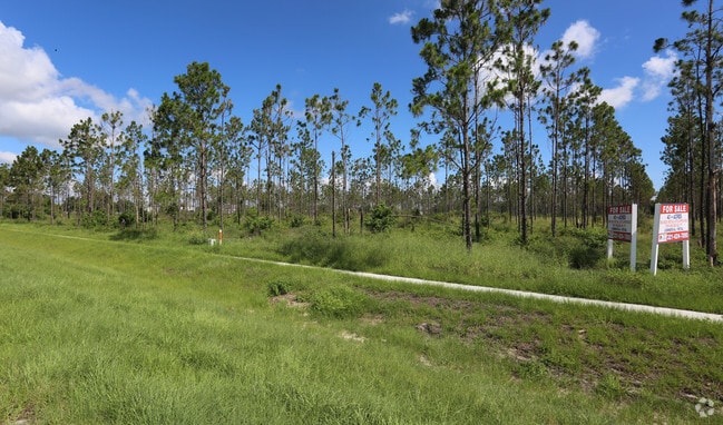
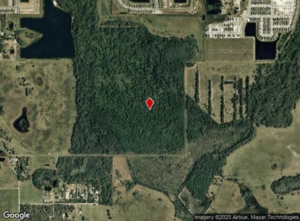
Property Record
E Irlo Bronson Mem Hwy, Saint Cloud, FL 34771
NEARBY LISTINGS FOR SALE OR LEASE
Property Detail
E Irlo Bronson Mem Hwy
Orlando-Kissimmee-Sanford, FL
Acreage & Unrec
05-26-31-00U0-0060-0000
SE 1/4 OF SW 1/4 OF SEC 05/26/31 & BEG 1322 FT E OF NW COR OF SEC 8/26/31, E 1316.7 FT, S 110 FT TO N LINE OF ST RD 24, W ALONG RD R/W TO POINT DUE S OF POB, N 73 FT TO POB LESS RD R/W HWY 441
Timberlandforesttreesagricultural
Osceola
X
Florida
12097C0280G
60
2022
41.67 AC
2022
Osceola Outlying
043700
Orlando
DEMOGRAPHICS near E Irlo Bronson Mem Hwy
1 Mile
3 Mile
5 Mile
2024 Total Population
6,050
29,202
77,132
2029 Population
7,425
35,674
93,238
Pop Growth 2024-2029
+ 22.73%
+ 22.16%
+ 20.88%
Average Age
40
40
39
2024 Total Households
2,074
10,448
26,592
HH Growth 2024-2029
+ 22.61%
+ 22.01%
+ 20.71%
Median Household Inc
$79,994
$69,738
$70,174
Avg Household Size
2.90
2.80
2.90
2024 Avg HH Vehicles
2.00
2.00
2.00
Median Home Value
$359,936
$329,273
$319,658
Median Year Built
2010
2002
2003
Nearby Places
Map Layers
Map Styles
 Street
 Aerial
- Restaurants
- Banks
- Shops
- Fitness
- Groceries
PUBLIC TRANSPORTATION
AIRPORT
Orlando International
DRIVE
WALK
Distance
Orlando International
34 min
19.6 mi
Freight Ports
Port Canaveral
DRIVE
WALK
Distance
Port Canaveral
72 min
53.2 mi
SALE & LEASE HISTORY
LISTING DATE
SALE/LEASE

Jul 13, 2017
For Sale
Nearby Properties
Address
Land Use
TOTAL SIZE
Lot Size
Zoning
Address
Land Use
TOTAL SIZE
Lot Size
Zoning
55,521 SF
10.75 AC
SHB
Address
Land Use
TOTAL SIZE
Lot Size
Zoning
30,520 SF
5.94 AC
SHB
Address
Land Use
TOTAL SIZE
Lot Size
Zoning
159.30 AC
Address
Land Use
TOTAL SIZE
Lot Size
Zoning
13.38 AC
Address
Land Use
TOTAL SIZE
Lot Size
Zoning
44,380 SF
7.84 AC
SHB
Address
Land Use
TOTAL SIZE
Lot Size
Zoning
5,782 SF
60.30 AC
OAC
Address
Land Use
TOTAL SIZE
Lot Size
Zoning
159.24 AC
OAC
Address
Land Use
TOTAL SIZE
Lot Size
Zoning
20,634 SF
4.55 AC
SHB
Address
Land Use
TOTAL SIZE
Lot Size
Zoning
50,570 SF
4.98 AC
SPUD
Address
Land Use
TOTAL SIZE
Lot Size
Zoning
99.81 AC
Address
Land Use
TOTAL SIZE
Lot Size
Zoning
14,234 SF
1.79 AC
SHB
Address
Land Use
TOTAL SIZE
Lot Size
Zoning
35,838 SF
20.56 AC
SA
Address
Land Use
TOTAL SIZE
Lot Size
Zoning
13,712 SF
1.06 AC
SNB
Address
Land Use
TOTAL SIZE
Lot Size
Zoning
1,104 SF
11.77 AC
OCG
Address
Land Use
TOTAL SIZE
Lot Size
Zoning
59.90 AC
Address
Land Use
TOTAL SIZE
Lot Size
Zoning
22.31 AC
OAC
Address
Land Use
TOTAL SIZE
Lot Size
Zoning
30,200 SF
2.62 AC
OCR
Address
Land Use
TOTAL SIZE
Lot Size
Zoning
19,192 SF
3.21 AC
OPD
Address
Land Use
TOTAL SIZE
Lot Size
Zoning
33,840 SF
2.95 AC
SPUD
Address
Land Use
TOTAL SIZE
Lot Size
Zoning
4.73 AC
Address
Land Use
TOTAL SIZE
Lot Size
Zoning
4,365 SF
0.96 AC
SHB
Address
Land Use
TOTAL SIZE
Lot Size
Zoning
10,635 SF
1.48 AC
Address
Land Use
TOTAL SIZE
Lot Size
Zoning
4,557 SF
1.39 AC
OPD
Address
Land Use
TOTAL SIZE
Lot Size
Zoning
1,944 SF
16.47 AC
SA
Address
Land Use
TOTAL SIZE
Lot Size
Zoning
13,001 SF
5.34 AC
OAC
Address
Land Use
TOTAL SIZE
Lot Size
Zoning
2,898 SF
0.90 AC
OCR
Address
Land Use
TOTAL SIZE
Lot Size
Zoning
10,800 SF
1.44 AC
SHB
Address
Land Use
TOTAL SIZE
Lot Size
Zoning
29.58 AC
Address
Land Use
TOTAL SIZE
Lot Size
Zoning
33,514 SF
3.50 AC
SI2
Address
Land Use
TOTAL SIZE
Lot Size
Zoning
8,093 SF
0.88 AC
OCR
The World's #1 Commercial Real Estate Marketplace
Connect with us
© 2025 CoStar Group
The information above has been obtained from sources believed reliable. While we do not doubt its accuracy we have not verified it and make no guarantee, warranty or representation about it. It is your responsibility to independently confirm its accuracy and completeness. Any projections, opinions, assumptions, or estimates used are for example only and do not represent the current or future performance of the property. The value of this transaction to you depends on tax and other factors which should be evaluated by your tax, financial, and legal advisors. You and your advisors should conduct a careful, independent investigation of the property to determine to your satisfaction the suitability of the property for your needs.