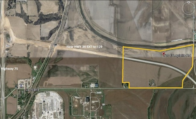
Property Record
E La Platte Rd, , NE

NEARBY LISTINGS FOR SALE OR LEASE
Property Detail
E La Platte Rd
Omaha, NE-IA
PT TAX LOT 7 EXC PT FOR NRD & PT OF TAX LOT 12 LYING NORTH OF NEW HWY ROW EXC PT FOR NRD 24-13-13 (51.91 AC)
011591955
Sarpy
Agriculturalland
Nebraska
AE
7,12
31025C0125D
51.91 AC
2024
Southeast Omaha
2025
Omaha/Council Bluffs
010305
DEMOGRAPHICS near E La Platte Rd
1 Mile
3 Mile
5 Mile
2024 Total Population
9
5,202
43,405
2029 Population
10
5,651
46,674
Pop Growth 2024-2029
+ 11.11%
+ 8.63%
+ 7.53%
Average Age
28
38
37
2024 Total Households
4
1,967
16,379
HH Growth 2024-2029
0.00%
+ 8.80%
+ 7.61%
Median Household Inc
$87,500
$105,393
$72,625
Avg Household Size
2.50
2.60
2.60
2024 Avg HH Vehicles
2.00
2.00
2.00
Median Home Value
$199,999
$310,051
$229,015
Median Year Built
1979
2004
1986
Nearby Places
Map Layers
Map Styles
 Street
 Aerial
- Restaurants
- Banks
- Shops
- Fitness
- Groceries
PUBLIC TRANSPORTATION
AIRPORT
Eppley Airfield
DRIVE
WALK
Distance
Eppley Airfield
33 min
21.1 mi
Freight Ports
Tulsa Port Of Catoosa
DRIVE
WALK
Distance
Tulsa Port Of Catoosa
448 min
406.5 mi
SALE & LEASE HISTORY
LISTING DATE
SALE/LEASE

Sep 24, 2016
For Sale
Nov 03, 2016
For Sale
Feb 18, 2020
For Sale
Nearby Properties
Address
Land Use
TOTAL SIZE
Lot Size
Zoning
Address
Land Use
TOTAL SIZE
Lot Size
Zoning
2,440 SF
18.88 AC
RG28
Address
Land Use
TOTAL SIZE
Lot Size
Zoning
121,660 SF
9.23 AC
RG28
Address
Land Use
TOTAL SIZE
Lot Size
Zoning
141,620 SF
84.13 AC
ILM
Address
Land Use
TOTAL SIZE
Lot Size
Zoning
Address
Land Use
TOTAL SIZE
Lot Size
Zoning
101,606 SF
5.01 AC
RG20
Address
Land Use
TOTAL SIZE
Lot Size
Zoning
4.75 AC
IGM
Address
Land Use
TOTAL SIZE
Lot Size
Zoning
5,400 SF
0.80 AC
MH
Address
Land Use
TOTAL SIZE
Lot Size
Zoning
43.33 AC
RD50
Address
Land Use
TOTAL SIZE
Lot Size
Zoning
12,000 SF
2.95 AC
03-COMMERC
Address
Land Use
TOTAL SIZE
Lot Size
Zoning
1,152 SF
319.20 AC
AG
Address
Land Use
TOTAL SIZE
Lot Size
Zoning
10,000 SF
34.82 AC
04-INDUSTR
Address
Land Use
TOTAL SIZE
Lot Size
Zoning
5,001 SF
4.91 AC
Address
Land Use
TOTAL SIZE
Lot Size
Zoning
304.68 AC
AG
Address
Land Use
TOTAL SIZE
Lot Size
Zoning
292.40 AC
AG
Address
Land Use
TOTAL SIZE
Lot Size
Zoning
14,758 SF
43.38 AC
AG
Address
Land Use
TOTAL SIZE
Lot Size
Zoning
48,677 SF
0.74 AC
IL
Address
Land Use
TOTAL SIZE
Lot Size
Zoning
8,225 SF
11.99 AC
IL
Address
Land Use
TOTAL SIZE
Lot Size
Zoning
5,092 SF
1.78 AC
BNH
Address
Land Use
TOTAL SIZE
Lot Size
Zoning
8,000 SF
12.95 AC
03-COMMERC
Address
Land Use
TOTAL SIZE
Lot Size
Zoning
24,000 SF
2.70 AC
IL
Address
Land Use
TOTAL SIZE
Lot Size
Zoning
864 SF
74.43 AC
RD50
Address
Land Use
TOTAL SIZE
Lot Size
Zoning
14,760 SF
4.48 AC
BHS
Address
Land Use
TOTAL SIZE
Lot Size
Zoning
15.02 AC
Address
Land Use
TOTAL SIZE
Lot Size
Zoning
28.05 AC
03-COMMERC
Address
Land Use
TOTAL SIZE
Lot Size
Zoning
5,280 SF
113.22 AC
AG
Address
Land Use
TOTAL SIZE
Lot Size
Zoning
2,709 SF
138.39 AC
AG
Address
Land Use
TOTAL SIZE
Lot Size
Zoning
14.76 AC
RS72
Address
Land Use
TOTAL SIZE
Lot Size
Zoning
7,169 SF
9.77 AC
AG
The World's #1 Commercial Real Estate Marketplace
Connect with us
© 2026 CoStar Group
The information above has been obtained from sources believed reliable. While we do not doubt its accuracy we have not verified it and make no guarantee, warranty or representation about it. It is your responsibility to independently confirm its accuracy and completeness. Any projections, opinions, assumptions, or estimates used are for example only and do not represent the current or future performance of the property. The value of this transaction to you depends on tax and other factors which should be evaluated by your tax, financial, and legal advisors. You and your advisors should conduct a careful, independent investigation of the property to determine to your satisfaction the suitability of the property for your needs.