Property Record
Lowr River Rd, Sanford, NC 27330
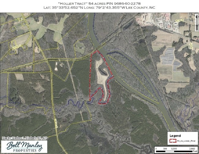
This Property Is For Sale
NEARBY LISTINGS FOR SALE OR LEASE
Property Detail
Lowr River Rd
Sanford, NC
TRACT 1 PLAT 2021/200 1311/648
9685-49-8870-00
Lee
Residentialnec
North Carolina
2025
99.49 AC
2025
North Carolina Southeast Area
030101
Other Market Areas
DEMOGRAPHICS near Lowr River Rd
1 mile
3 mile
5 mile
2024 Total Population
50
784
3,545
2029 Population
55
861
3,878
Pop Growth 2024-2029
+ 10.00%
+ 9.82%
+ 9.39%
Average Age
44
43
43
2024 Total Households
19
304
1,391
HH Growth 2024-2029
+ 10.53%
+ 9.87%
+ 9.56%
Median Household Inc
$59,999
$59,218
$60,433
Avg Household Size
2.30
2.40
2.40
2024 Avg HH Vehicles
3.00
3.00
2.00
Median Home Value
$199,999
$196,710
$192,789
Median Year Built
1987
1986
1988
Nearby Places
Map Layers
Map Styles
 Street
 Aerial
Transit
 Traffic
 Biking
Places
Listings with unknown addresses are not visible on the map
- Restaurants
- Banks
- Shops
- Fitness
- Groceries
PUBLIC TRANSPORTATION
AIRPORT
Raleigh-Durham International
Drive
Walk
Distance
Raleigh-Durham International
52 min
36.7 mi
Freight Ports
Port of Wilmington
Drive
Walk
Distance
Port of Wilmington
181 min
145.6 mi
Nearby Properties
Address
Land Use
TOTAL SIZE
Lot Size
Zoning
Address
Land Use
TOTAL SIZE
Lot Size
Zoning
280,718 SF
296.13 AC
IND-H
Address
Land Use
TOTAL SIZE
Lot Size
Zoning
252,798 SF
103.69 AC
IND-H
Address
Land Use
TOTAL SIZE
Lot Size
Zoning
1,364.09 AC
RESIDENTIA
Address
Land Use
TOTAL SIZE
Lot Size
Zoning
6,136 SF
90.73 AC
RESIDENTIA
Address
Land Use
TOTAL SIZE
Lot Size
Zoning
122,351 SF
17.49 AC
IND-H
Address
Land Use
TOTAL SIZE
Lot Size
Zoning
1,264 SF
483.06 AC
IND-H
Address
Land Use
TOTAL SIZE
Lot Size
Zoning
145,510 SF
119.45 AC
IND-H
Address
Land Use
TOTAL SIZE
Lot Size
Zoning
11,928 SF
28.69 AC
IND-H
Address
Land Use
TOTAL SIZE
Lot Size
Zoning
1,920 SF
35.12 AC
R-1
Address
Land Use
TOTAL SIZE
Lot Size
Zoning
294.14 AC
RESIDENTIA
Address
Land Use
TOTAL SIZE
Lot Size
Zoning
735 SF
274.62 AC
RESIDENTIA
Address
Land Use
TOTAL SIZE
Lot Size
Zoning
4,428 SF
11.96 AC
R-1
Address
Land Use
TOTAL SIZE
Lot Size
Zoning
5,468 SF
19.04 AC
R-1
Address
Land Use
TOTAL SIZE
Lot Size
Zoning
302.93 AC
RESIDENTIA
Address
Land Use
TOTAL SIZE
Lot Size
Zoning
273.49 AC
CU-IND-H
Address
Land Use
TOTAL SIZE
Lot Size
Zoning
4,618 SF
12.53 AC
R-1
Address
Land Use
TOTAL SIZE
Lot Size
Zoning
1,473 SF
78.44 AC
R-1
Address
Land Use
TOTAL SIZE
Lot Size
Zoning
2,675 SF
10.11 AC
R-1
Address
Land Use
TOTAL SIZE
Lot Size
Zoning
264.75 AC
RESIDENTIA
Address
Land Use
TOTAL SIZE
Lot Size
Zoning
2,726 SF
159.88 AC
RESIDENTIA
Address
Land Use
TOTAL SIZE
Lot Size
Zoning
1,668 SF
155.18 AC
RESIDENTIA
Address
Land Use
TOTAL SIZE
Lot Size
Zoning
198.80 AC
RESIDENTIA
Address
Land Use
TOTAL SIZE
Lot Size
Zoning
4,467 SF
46.60 AC
RESIDENTIA
Address
Land Use
TOTAL SIZE
Lot Size
Zoning
1,500 SF
7.76 AC
RESIDENTIA
Address
Land Use
TOTAL SIZE
Lot Size
Zoning
167.59 AC
RESIDENTIA
Address
Land Use
TOTAL SIZE
Lot Size
Zoning
2,464 SF
105.92 AC
RESIDENTIA
Address
Land Use
TOTAL SIZE
Lot Size
Zoning
46.80 AC
R-1
Address
Land Use
TOTAL SIZE
Lot Size
Zoning
4,388 SF
4.71 AC
R-1
Address
Land Use
TOTAL SIZE
Lot Size
Zoning
2,514 SF
28.73 AC
RESIDENTIA
Address
Land Use
TOTAL SIZE
Lot Size
Zoning
2,083 SF
36.17 AC
R-1
The World's #1 Commercial Real Estate Marketplace
Connect with us
© 2026 CoStar Group
The information above has been obtained from sources believed reliable. While we do not doubt its accuracy we have not verified it and make no guarantee, warranty or representation about it. It is your responsibility to independently confirm its accuracy and completeness. Any projections, opinions, assumptions, or estimates used are for example only and do not represent the current or future performance of the property. The value of this transaction to you depends on tax and other factors which should be evaluated by your tax, financial, and legal advisors. You and your advisors should conduct a careful, independent investigation of the property to determine to your satisfaction the suitability of the property for your needs.