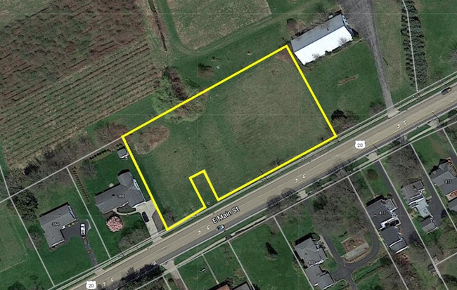
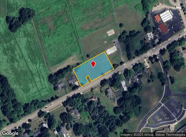
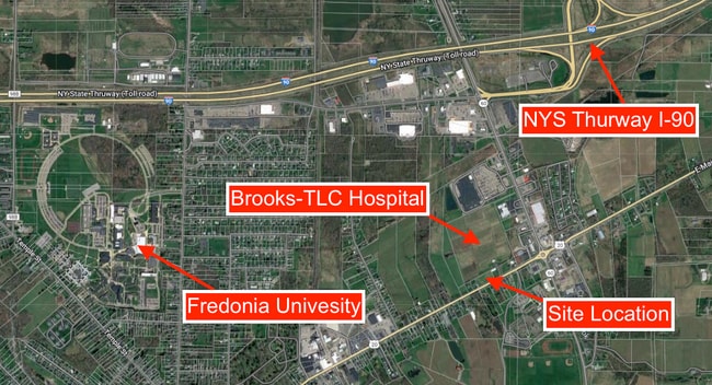
Property Record
E Main St, Fredonia, NY 14063
NEARBY LISTINGS FOR SALE OR LEASE
-
-
View all Fredonia listings for sale on LoopNet.com
Property Detail
E Main St
Other Market Areas
OLD APN: 065801 110-2-15
Jamestown-Dunkirk-Fredonia, NY
Chautauqua
065801-113-008-0001-030-000
New York
Residentialacreage
30.000
2025
1.50 AC
2024
New York West Area
035901
DEMOGRAPHICS near E Main St
1 Mile
3 Mile
5 Mile
2024 Total Population
2,171
21,877
26,356
2029 Population
2,154
21,291
25,716
Pop Growth 2024-2029
(0.78%)
(2.68%)
(2.43%)
Average Age
42
40
41
2024 Total Households
1,039
8,755
10,637
HH Growth 2024-2029
(0.87%)
(2.97%)
(2.67%)
Median Household Inc
$50,294
$43,539
$44,830
Avg Household Size
2.10
2.20
2.20
2024 Avg HH Vehicles
2.00
1.00
2.00
Median Home Value
$147,138
$102,997
$107,124
Median Year Built
1953
1949
1950
Nearby Places
- Restaurants
- Banks
- Shops
- Fitness
- Groceries
SALE & LEASE HISTORY
LISTING DATE
SALE/LEASE

Jul 31, 2024
For Sale
Nearby Properties
Address
Land Use
TOTAL SIZE
Lot Size
Zoning
Address
Land Use
TOTAL SIZE
Lot Size
Zoning
135,304 SF
4.96 AC
CBD
Address
Land Use
TOTAL SIZE
Lot Size
Zoning
163,219 SF
6.50 AC
M2
Address
Land Use
TOTAL SIZE
Lot Size
Zoning
1,300 SF
16 AC
M1
Address
Land Use
TOTAL SIZE
Lot Size
Zoning
542,989 SF
47.40 AC
L1
Address
Land Use
TOTAL SIZE
Lot Size
Zoning
153,111 SF
12.70 AC
R2
Address
Land Use
TOTAL SIZE
Lot Size
Zoning
15,244 SF
19.36 AC
M2
Address
Land Use
TOTAL SIZE
Lot Size
Zoning
113,097 SF
8.20 AC
HC
Address
Land Use
TOTAL SIZE
Lot Size
Zoning
93,000 SF
14 AC
Address
Land Use
TOTAL SIZE
Lot Size
Zoning
90,660 SF
5.30 AC
HC
Address
Land Use
TOTAL SIZE
Lot Size
Zoning
99,617 SF
4.96 AC
R2
Address
Land Use
TOTAL SIZE
Lot Size
Zoning
21,000 SF
11.70 AC
HC
Address
Land Use
TOTAL SIZE
Lot Size
Zoning
2.11 AC
CBD
Address
Land Use
TOTAL SIZE
Lot Size
Zoning
143,375 SF
24.70 AC
C2
Address
Land Use
TOTAL SIZE
Lot Size
Zoning
10,000 SF
1.10 AC
C2
Address
Land Use
TOTAL SIZE
Lot Size
Zoning
85,175 SF
5.40 AC
C1
Address
Land Use
TOTAL SIZE
Lot Size
Zoning
29.90 AC
07 - MIXED
Address
Land Use
TOTAL SIZE
Lot Size
Zoning
21.70 AC
07 - MIXED
Address
Land Use
TOTAL SIZE
Lot Size
Zoning
4,988 SF
12.90 AC
R1
Address
Land Use
TOTAL SIZE
Lot Size
Zoning
1,748 SF
88.70 AC
Address
Land Use
TOTAL SIZE
Lot Size
Zoning
30,882 SF
10.58 AC
M2
Address
Land Use
TOTAL SIZE
Lot Size
Zoning
31,715 SF
3.20 AC
CR
Address
Land Use
TOTAL SIZE
Lot Size
Zoning
20.60 AC
CR
Address
Land Use
TOTAL SIZE
Lot Size
Zoning
18,914 SF
7.35 AC
M2
Address
Land Use
TOTAL SIZE
Lot Size
Zoning
190,873 SF
21.50 AC
V1
Address
Land Use
TOTAL SIZE
Lot Size
Zoning
1.70 AC
Address
Land Use
TOTAL SIZE
Lot Size
Zoning
28,740 SF
56.70 AC
M2
Address
Land Use
TOTAL SIZE
Lot Size
Zoning
65,201 SF
7.20 AC
HC
Address
Land Use
TOTAL SIZE
Lot Size
Zoning
7.10 AC
Address
Land Use
TOTAL SIZE
Lot Size
Zoning
27,238 SF
1.60 AC
C1
Address
Land Use
TOTAL SIZE
Lot Size
Zoning
30,205 SF
4.18 AC
R3
The World's #1 Commercial Real Estate Marketplace
Connect with us
© 2025 CoStar Group
The information above has been obtained from sources believed reliable. While we do not doubt its accuracy we have not verified it and make no guarantee, warranty or representation about it. It is your responsibility to independently confirm its accuracy and completeness. Any projections, opinions, assumptions, or estimates used are for example only and do not represent the current or future performance of the property. The value of this transaction to you depends on tax and other factors which should be evaluated by your tax, financial, and legal advisors. You and your advisors should conduct a careful, independent investigation of the property to determine to your satisfaction the suitability of the property for your needs.