Property Record
E Main St, Jacksonville, AR 72076


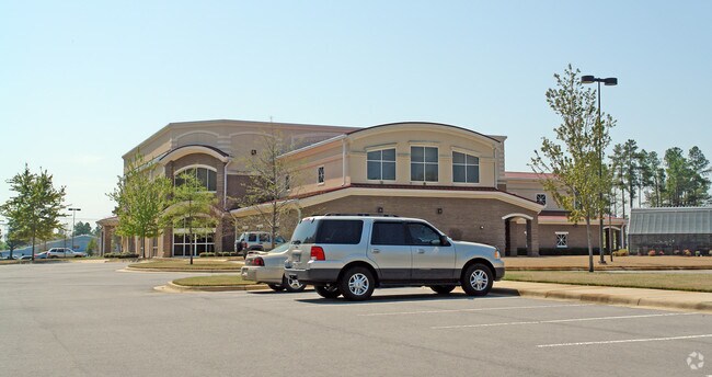
Property Detail
E Main St
22J-011-00-021-00
PT E1/2 SW SECTION 24-3N-11 MPDA BEG NLN WEST MAIN STREET LYING IN THE SW COR SE SW SECTION 24 TH AL THE ELN REDMOND ROAD N1538.2 TH CONTINUE N010340W AL THE ELN REDMOND ROAD 367.05 S89*55E1121.51 TO THE W R/W L
Officebuilding
PULASKI
B and X Area of moderate flood hazard, usually the area between the limits of the 100-year and 500-year floods.
Arkansas
2025
50.12 AC
2025
Outlying Pulaski County
003604
Little Rock/N Little Rock
92,654 SF
Little Rock-North Little Rock-Conway, AR
NEARBY LISTINGS FOR SALE OR LEASE
DEMOGRAPHICS near E Main St
1 mile
3 mile
5 mile
2025 Total Population
2,415
29,308
55,944
2030 Population
2,415
29,560
56,442
Pop Growth 2025-2030
0.00%
+ 0.86%
+ 0.89%
Average Age
38
37
38
2025 Total Households
970
11,561
22,383
HH Growth 2025-2030
+ 0.10%
+ 0.83%
+ 0.87%
Median Household Inc
$66,038
$50,510
$58,935
Avg Household Size
2.40
2.40
2.40
2025 Avg HH Vehicles
2.00
2.00
2.00
Median Home Value
$250,487
$169,573
$195,760
Median Year Built
1985
1979
1984
Nearby Places
Map Layers
Map Styles
 Street
 Aerial
Layers
 Traffic
 Biking
Places
Listings with unknown addresses are not visible on the map
- Restaurants
- Banks
- Shops
- Fitness
- Groceries
PUBLIC TRANSPORTATION
AIRPORT
Bill and Hillary Clinton Ntl/Adams Field
Drive
Walk
Distance
Bill and Hillary Clinton Ntl/Adams Field
22 min
15.9 mi
Nearby Properties
Address
Land Use
TOTAL SIZE
Lot Size
Zoning
Address
Land Use
TOTAL SIZE
Lot Size
Zoning
78,183 SF
2.77 AC
Address
Land Use
TOTAL SIZE
Lot Size
Zoning
338,000 SF
22.81 AC
Address
Land Use
TOTAL SIZE
Lot Size
Zoning
116,987 SF
39.02 AC
Address
Land Use
TOTAL SIZE
Lot Size
Zoning
6,099.88 AC
Address
Land Use
TOTAL SIZE
Lot Size
Zoning
130,195 SF
10.11 AC
Address
Land Use
TOTAL SIZE
Lot Size
Zoning
10 SF
10.14 AC
Address
Land Use
TOTAL SIZE
Lot Size
Zoning
5,850 SF
21.81 AC
Address
Land Use
TOTAL SIZE
Lot Size
Zoning
55,127 SF
11.26 AC
Address
Land Use
TOTAL SIZE
Lot Size
Zoning
76,936 SF
48.38 AC
Address
Land Use
TOTAL SIZE
Lot Size
Zoning
137,320 SF
14.27 AC
Address
Land Use
TOTAL SIZE
Lot Size
Zoning
60,232 SF
12.88 AC
Address
Land Use
TOTAL SIZE
Lot Size
Zoning
45,006 SF
6.33 AC
Address
Land Use
TOTAL SIZE
Lot Size
Zoning
37,333 SF
6.43 AC
Address
Land Use
TOTAL SIZE
Lot Size
Zoning
58,120 SF
8.58 AC
Address
Land Use
TOTAL SIZE
Lot Size
Zoning
71,861 SF
5.91 AC
Address
Land Use
TOTAL SIZE
Lot Size
Zoning
36,642 SF
3.99 AC
Address
Land Use
TOTAL SIZE
Lot Size
Zoning
86,675 SF
4.73 AC
Address
Land Use
TOTAL SIZE
Lot Size
Zoning
68,246 SF
10.71 AC
Address
Land Use
TOTAL SIZE
Lot Size
Zoning
71,046 SF
9.18 AC
Address
Land Use
TOTAL SIZE
Lot Size
Zoning
33,668 SF
2.67 AC
Address
Land Use
TOTAL SIZE
Lot Size
Zoning
34,988 SF
9.14 AC
Address
Land Use
TOTAL SIZE
Lot Size
Zoning
6,576 SF
122.66 AC
Address
Land Use
TOTAL SIZE
Lot Size
Zoning
14,005 SF
5.45 AC
Address
Land Use
TOTAL SIZE
Lot Size
Zoning
1,426 SF
3.28 AC
Address
Land Use
TOTAL SIZE
Lot Size
Zoning
43,630 SF
12.38 AC
Address
Land Use
TOTAL SIZE
Lot Size
Zoning
7,853 SF
6.12 AC
Address
Land Use
TOTAL SIZE
Lot Size
Zoning
8,944 SF
10.64 AC
Address
Land Use
TOTAL SIZE
Lot Size
Zoning
37,258 SF
6.49 AC
Address
Land Use
TOTAL SIZE
Lot Size
Zoning
28,329 SF
10.40 AC
The World's #1 Commercial Real Estate Marketplace
Connect with us
© 2026 CoStar Group
The information above has been obtained from sources believed reliable. While we do not doubt its accuracy we have not verified it and make no guarantee, warranty or representation about it. It is your responsibility to independently confirm its accuracy and completeness. Any projections, opinions, assumptions, or estimates used are for example only and do not represent the current or future performance of the property. The value of this transaction to you depends on tax and other factors which should be evaluated by your tax, financial, and legal advisors. You and your advisors should conduct a careful, independent investigation of the property to determine to your satisfaction the suitability of the property for your needs.