Property Record
Graham Rd, Greenwood, IN 46142
NEARBY LISTINGS FOR SALE OR LEASE
Property Detail
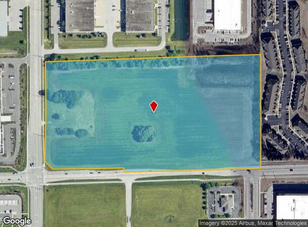
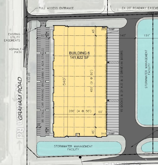
Graham Rd
41-02-35-023-031.000-030
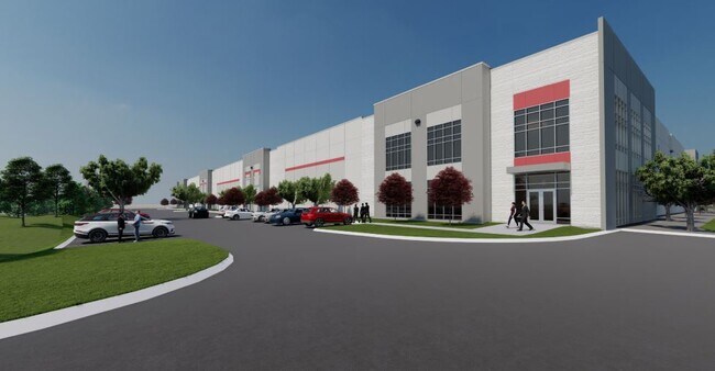
Southtech Park Secondary
Agriculturalland
SOUTHTECH PARK SECONDARY PLAT BLOCK B
X
Johnson
18081C0127D
Indiana
2024
20.52 AC
2025
Johnson County
610606
Indianapolis
2,850 SF
Indianapolis-Carmel-Anderson, IN
DEMOGRAPHICS near Graham Rd
1 Mile
3 Mile
5 Mile
2024 Total Population
4,857
47,683
133,426
2029 Population
5,229
49,773
137,272
Pop Growth 2024-2029
+ 7.66%
+ 4.38%
+ 2.88%
Average Age
38
39
38
2024 Total Households
1,873
18,805
51,273
HH Growth 2024-2029
+ 7.79%
+ 4.63%
+ 2.99%
Median Household Inc
$80,393
$76,025
$74,334
Avg Household Size
2.60
2.50
2.50
2024 Avg HH Vehicles
2.00
2.00
2.00
Median Home Value
$283,625
$203,374
$212,742
Median Year Built
2000
1995
1991
Nearby Places
- Restaurants
- Banks
- Shops
- Fitness
- Groceries
PUBLIC TRANSPORTATION
AIRPORT
Indianapolis International
DRIVE
WALK
Distance
Indianapolis International
37 min
23.9 mi
Freight Ports
Port of Toledo
DRIVE
WALK
Distance
Port of Toledo
282 min
235.8 mi
Nearby Properties
Address
Land Use
TOTAL SIZE
Lot Size
Zoning
Address
Land Use
TOTAL SIZE
Lot Size
Zoning
31,217 SF
105.06 AC
ZO01
Address
Land Use
TOTAL SIZE
Lot Size
Zoning
816,376 SF
65.10 AC
Address
Land Use
TOTAL SIZE
Lot Size
Zoning
615,440 SF
78.64 AC
Address
Land Use
TOTAL SIZE
Lot Size
Zoning
10,540 SF
49.19 AC
ZO01
Address
Land Use
TOTAL SIZE
Lot Size
Zoning
670,880 SF
43.43 AC
Address
Land Use
TOTAL SIZE
Lot Size
Zoning
420,084 SF
23.83 AC
Address
Land Use
TOTAL SIZE
Lot Size
Zoning
799,575 SF
37.56 AC
Address
Land Use
TOTAL SIZE
Lot Size
Zoning
446,500 SF
45.43 AC
Address
Land Use
TOTAL SIZE
Lot Size
Zoning
493,560 SF
31.39 AC
Address
Land Use
TOTAL SIZE
Lot Size
Zoning
511,680 SF
37.57 AC
Address
Land Use
TOTAL SIZE
Lot Size
Zoning
667,500 SF
33.46 AC
Address
Land Use
TOTAL SIZE
Lot Size
Zoning
5,576 SF
14.15 AC
ZO01
Address
Land Use
TOTAL SIZE
Lot Size
Zoning
581,612 SF
33.53 AC
Address
Land Use
TOTAL SIZE
Lot Size
Zoning
81,996 SF
8.56 AC
Address
Land Use
TOTAL SIZE
Lot Size
Zoning
4,970 SF
24.77 AC
Address
Land Use
TOTAL SIZE
Lot Size
Zoning
470,000 SF
22.75 AC
Address
Land Use
TOTAL SIZE
Lot Size
Zoning
181,458 SF
6 AC
Address
Land Use
TOTAL SIZE
Lot Size
Zoning
273,000 SF
22.28 AC
Address
Land Use
TOTAL SIZE
Lot Size
Zoning
1,968 SF
37.45 AC
Address
Land Use
TOTAL SIZE
Lot Size
Zoning
612,000 SF
31.01 AC
Address
Land Use
TOTAL SIZE
Lot Size
Zoning
331,200 SF
23.40 AC
Address
Land Use
TOTAL SIZE
Lot Size
Zoning
4,027 SF
24.71 AC
Address
Land Use
TOTAL SIZE
Lot Size
Zoning
5,401 SF
21.94 AC
ZO01
Address
Land Use
TOTAL SIZE
Lot Size
Zoning
4,722 SF
25.71 AC
Address
Land Use
TOTAL SIZE
Lot Size
Zoning
146,716 SF
25.43 AC
Address
Land Use
TOTAL SIZE
Lot Size
Zoning
110,598 SF
22.82 AC
ZO01
Address
Land Use
TOTAL SIZE
Lot Size
Zoning
2,480 SF
14.45 AC
Address
Land Use
TOTAL SIZE
Lot Size
Zoning
232,156 SF
23.19 AC
Address
Land Use
TOTAL SIZE
Lot Size
Zoning
99,178 SF
18.04 AC
Address
Land Use
TOTAL SIZE
Lot Size
Zoning
290,258 SF
21.37 AC
The World's #1 Commercial Real Estate Marketplace
Connect with us
© 2025 CoStar Group
The information above has been obtained from sources believed reliable. While we do not doubt its accuracy we have not verified it and make no guarantee, warranty or representation about it. It is your responsibility to independently confirm its accuracy and completeness. Any projections, opinions, assumptions, or estimates used are for example only and do not represent the current or future performance of the property. The value of this transaction to you depends on tax and other factors which should be evaluated by your tax, financial, and legal advisors. You and your advisors should conduct a careful, independent investigation of the property to determine to your satisfaction the suitability of the property for your needs.