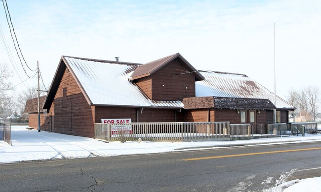
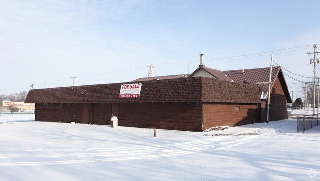
Property Record
E Main St, Russells Point, OH 43348

Property Detail
E Main St
52-032-09-07-004-000
LOGAN
Commercialnec
Ohio
AE The base floodplain where base flood elevations are provided. AE Zones are now used on new format FIRMs instead of A1-A30 Zones.
0.54 AC
0
Other Market Areas
2025
Bellefontaine, OH
004200
NEARBY LISTINGS FOR SALE OR LEASE
DEMOGRAPHICS near E Main St
1 mile
3 mile
5 mile
2025 Total Population
2,590
8,432
12,624
2030 Population
2,771
8,953
13,388
Pop Growth 2025-2030
+ 6.99%
+ 6.18%
+ 6.05%
Average Age
43
46
47
2025 Total Households
1,202
4,010
5,951
HH Growth 2025-2030
+ 6.66%
+ 6.18%
+ 6.10%
Median Household Inc
$50,078
$59,210
$63,739
Avg Household Size
2.20
2.10
2.10
2025 Avg HH Vehicles
1.00
2.00
2.00
Median Home Value
$160,236
$190,423
$201,735
Median Year Built
1975
1975
1976
Nearby Places
Map Layers
Map Styles
 Street
 Aerial
Layers
 Traffic
 Biking
Places
Listings with unknown addresses are not visible on the map
- Restaurants
- Banks
- Shops
- Fitness
- Groceries
Nearby Properties
Address
Land Use
TOTAL SIZE
Lot Size
Zoning
Address
Land Use
TOTAL SIZE
Lot Size
Zoning
304,330 SF
49.42 AC
Address
Land Use
TOTAL SIZE
Lot Size
Zoning
72,752 SF
58.34 AC
Address
Land Use
TOTAL SIZE
Lot Size
Zoning
64,102 SF
88.14 AC
Address
Land Use
TOTAL SIZE
Lot Size
Zoning
2,152 SF
73.14 AC
Address
Land Use
TOTAL SIZE
Lot Size
Zoning
10,208 SF
Address
Land Use
TOTAL SIZE
Lot Size
Zoning
27,750 SF
4.60 AC
Address
Land Use
TOTAL SIZE
Lot Size
Zoning
10.84 AC
Address
Land Use
TOTAL SIZE
Lot Size
Zoning
322.96 AC
Address
Land Use
TOTAL SIZE
Lot Size
Zoning
Address
Land Use
TOTAL SIZE
Lot Size
Zoning
798 SF
2.47 AC
Address
Land Use
TOTAL SIZE
Lot Size
Zoning
5,192 SF
2.32 AC
Address
Land Use
TOTAL SIZE
Lot Size
Zoning
18,561 SF
3.16 AC
Address
Land Use
TOTAL SIZE
Lot Size
Zoning
232.36 AC
Address
Land Use
TOTAL SIZE
Lot Size
Zoning
5,400 SF
39.97 AC
Address
Land Use
TOTAL SIZE
Lot Size
Zoning
4,872 SF
5 AC
Address
Land Use
TOTAL SIZE
Lot Size
Zoning
12,000 SF
7.66 AC
Address
Land Use
TOTAL SIZE
Lot Size
Zoning
307.06 AC
Address
Land Use
TOTAL SIZE
Lot Size
Zoning
194.17 AC
Address
Land Use
TOTAL SIZE
Lot Size
Zoning
2,975 SF
66.04 AC
Address
Land Use
TOTAL SIZE
Lot Size
Zoning
Address
Land Use
TOTAL SIZE
Lot Size
Zoning
7,825 SF
0.64 AC
Address
Land Use
TOTAL SIZE
Lot Size
Zoning
164.73 AC
Address
Land Use
TOTAL SIZE
Lot Size
Zoning
10,004 SF
2.06 AC
Address
Land Use
TOTAL SIZE
Lot Size
Zoning
Address
Land Use
TOTAL SIZE
Lot Size
Zoning
4.85 AC
Address
Land Use
TOTAL SIZE
Lot Size
Zoning
41,050 SF
9.36 AC
Address
Land Use
TOTAL SIZE
Lot Size
Zoning
4,032 SF
2.36 AC
Address
Land Use
TOTAL SIZE
Lot Size
Zoning
8,800 SF
0.38 AC
Address
Land Use
TOTAL SIZE
Lot Size
Zoning
6.90 AC
Address
Land Use
TOTAL SIZE
Lot Size
Zoning
148.39 AC
The World's #1 Commercial Real Estate Marketplace
Connect with us
© 2026 CoStar Group
The information above has been obtained from sources believed reliable. While we do not doubt its accuracy we have not verified it and make no guarantee, warranty or representation about it. It is your responsibility to independently confirm its accuracy and completeness. Any projections, opinions, assumptions, or estimates used are for example only and do not represent the current or future performance of the property. The value of this transaction to you depends on tax and other factors which should be evaluated by your tax, financial, and legal advisors. You and your advisors should conduct a careful, independent investigation of the property to determine to your satisfaction the suitability of the property for your needs.