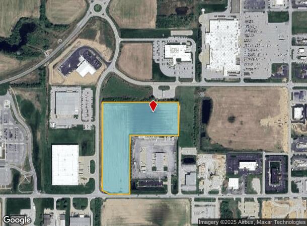
Property Record
E Margaret Dr, Terre Haute, IN 47802
NEARBY LISTINGS FOR SALE OR LEASE
Property Detail
E Margaret Dr
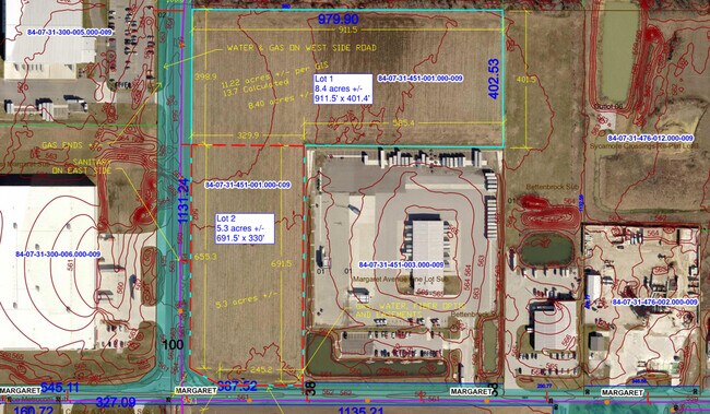
84-07-31-451-001.000-009
SW SW W EXCS TIF MISC-209/904 & 200114381 31-12-8 11.22 AC
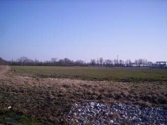
Agriculturalland
Vigo
X
Indiana
18167C0162C
11.22 AC
2024
Bloomington/Terre Haute
2024
Other Market Areas
010703
Terre Haute, IN
DEMOGRAPHICS near E Margaret Dr
1 Mile
3 Mile
5 Mile
2024 Total Population
634
18,838
63,450
2029 Population
627
18,623
63,640
Pop Growth 2024-2029
(1.10%)
(1.14%)
+ 0.30%
Average Age
39
41
38
2024 Total Households
297
8,333
25,923
HH Growth 2024-2029
(1.35%)
(1.31%)
+ 0.35%
Median Household Inc
$65,577
$54,063
$41,336
Avg Household Size
2.10
2.20
2.20
2024 Avg HH Vehicles
2.00
2.00
2.00
Median Home Value
$236,842
$151,295
$123,873
Median Year Built
1989
1969
1969
Nearby Places
Map Layers
Map Styles
 Street
 Aerial
- Restaurants
- Banks
- Shops
- Fitness
- Groceries
SALE & LEASE HISTORY
LISTING DATE
SALE/LEASE

Nov 18, 2022
For Sale
Nearby Properties
Address
Land Use
TOTAL SIZE
Lot Size
Zoning
Address
Land Use
TOTAL SIZE
Lot Size
Zoning
3,082 SF
11.23 AC
Address
Land Use
TOTAL SIZE
Lot Size
Zoning
175,320 SF
21.40 AC
Address
Land Use
TOTAL SIZE
Lot Size
Zoning
220,500 SF
20.83 AC
Address
Land Use
TOTAL SIZE
Lot Size
Zoning
10,187 SF
12.39 AC
Address
Land Use
TOTAL SIZE
Lot Size
Zoning
24,360 SF
6.01 AC
Address
Land Use
TOTAL SIZE
Lot Size
Zoning
76,356 SF
97.94 AC
Address
Land Use
TOTAL SIZE
Lot Size
Zoning
75,316 SF
2.30 AC
Address
Land Use
TOTAL SIZE
Lot Size
Zoning
46,926 SF
7.80 AC
Address
Land Use
TOTAL SIZE
Lot Size
Zoning
153,600 SF
10.44 AC
Address
Land Use
TOTAL SIZE
Lot Size
Zoning
194,233 SF
18.89 AC
Address
Land Use
TOTAL SIZE
Lot Size
Zoning
45,672 SF
2.67 AC
Address
Land Use
TOTAL SIZE
Lot Size
Zoning
45,622 SF
8.62 AC
Address
Land Use
TOTAL SIZE
Lot Size
Zoning
54,037 SF
2.86 AC
Address
Land Use
TOTAL SIZE
Lot Size
Zoning
8,344 SF
6.36 AC
Address
Land Use
TOTAL SIZE
Lot Size
Zoning
48,360 SF
11.95 AC
Address
Land Use
TOTAL SIZE
Lot Size
Zoning
2,228 SF
4.47 AC
Address
Land Use
TOTAL SIZE
Lot Size
Zoning
1,104 SF
5.15 AC
Address
Land Use
TOTAL SIZE
Lot Size
Zoning
20,050 SF
12.45 AC
Address
Land Use
TOTAL SIZE
Lot Size
Zoning
5,784 SF
4.24 AC
Address
Land Use
TOTAL SIZE
Lot Size
Zoning
29,600 SF
6.82 AC
Address
Land Use
TOTAL SIZE
Lot Size
Zoning
32,688 SF
41.32 AC
Address
Land Use
TOTAL SIZE
Lot Size
Zoning
13,988 SF
8.95 AC
Address
Land Use
TOTAL SIZE
Lot Size
Zoning
69,550 SF
7.43 AC
Address
Land Use
TOTAL SIZE
Lot Size
Zoning
14,260 SF
1.55 AC
Address
Land Use
TOTAL SIZE
Lot Size
Zoning
17,406 SF
2.48 AC
Address
Land Use
TOTAL SIZE
Lot Size
Zoning
3,400 SF
26.65 AC
Address
Land Use
TOTAL SIZE
Lot Size
Zoning
3,596 SF
4.36 AC
Address
Land Use
TOTAL SIZE
Lot Size
Zoning
10,876 SF
1.41 AC
Address
Land Use
TOTAL SIZE
Lot Size
Zoning
95,319 SF
5 AC
Address
Land Use
TOTAL SIZE
Lot Size
Zoning
70,679 SF
7.05 AC
The World's #1 Commercial Real Estate Marketplace
Connect with us
© 2025 CoStar Group
The information above has been obtained from sources believed reliable. While we do not doubt its accuracy we have not verified it and make no guarantee, warranty or representation about it. It is your responsibility to independently confirm its accuracy and completeness. Any projections, opinions, assumptions, or estimates used are for example only and do not represent the current or future performance of the property. The value of this transaction to you depends on tax and other factors which should be evaluated by your tax, financial, and legal advisors. You and your advisors should conduct a careful, independent investigation of the property to determine to your satisfaction the suitability of the property for your needs.