Property Record
E Oglethorpe Hwy, Hinesville, GA 31313
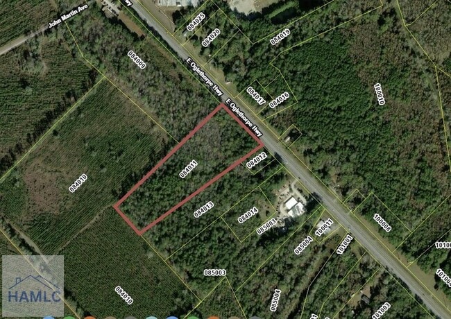


This Property Is For Sale
Property Detail
E Oglethorpe Hwy
084-011
9.329 AC W/S E OGLETHORPE HWY
Residentialacreage
LIBERTY
A1/R8
Georgia
AE The base floodplain where base flood elevations are provided. AE Zones are now used on new format FIRMs instead of A1-A30 Zones.
9.33 AC
2025
Liberty County
2025
Savannah
010205
Hinesville, GA
NEARBY LISTINGS FOR SALE OR LEASE
-
-
-
No Photo
-
-
-
-
-
View all Hinesville listings for sale on LoopNet.com
DEMOGRAPHICS near E Oglethorpe Hwy
1 mile
3 mile
5 mile
2025 Total Population
170
7,639
36,203
2030 Population
185
8,074
38,215
Pop Growth 2025-2030
+ 8.82%
+ 5.69%
+ 5.56%
Average Age
39
34
32
2025 Total Households
61
2,935
13,028
HH Growth 2025-2030
+ 9.84%
+ 5.96%
+ 5.82%
Median Household Inc
$84,722
$62,860
$57,699
Avg Household Size
2.80
2.60
2.60
2025 Avg HH Vehicles
3.00
2.00
2.00
Median Home Value
$266,666
$220,579
$192,116
Median Year Built
1999
1988
1990
Nearby Places
Map Layers
Map Styles
 Street
 Aerial
Layers
 Traffic
 Biking
Places
Listings with unknown addresses are not visible on the map
- Restaurants
- Banks
- Shops
- Fitness
- Groceries
PUBLIC TRANSPORTATION
AIRPORT
Savannah/Hilton Head International
Drive
Walk
Distance
Savannah/Hilton Head International
48 min
34.9 mi
Freight Ports
Georgia Ports - Savannah
Drive
Walk
Distance
Georgia Ports - Savannah
50 min
37.6 mi
Nearby Properties
Address
Land Use
TOTAL SIZE
Lot Size
Zoning
Address
Land Use
TOTAL SIZE
Lot Size
Zoning
315,645 SF
57.37 AC
A1/R8
Address
Land Use
TOTAL SIZE
Lot Size
Zoning
2,352 SF
22.31 AC
ATR/MFR
Address
Land Use
TOTAL SIZE
Lot Size
Zoning
144,251 SF
51.30 AC
R20
Address
Land Use
TOTAL SIZE
Lot Size
Zoning
60,432 SF
23.64 AC
R20
Address
Land Use
TOTAL SIZE
Lot Size
Zoning
41,670 SF
1.89 AC
C1
Address
Land Use
TOTAL SIZE
Lot Size
Zoning
17,376 SF
29.45 AC
OI
Address
Land Use
TOTAL SIZE
Lot Size
Zoning
10.58 AC
PUD
Address
Land Use
TOTAL SIZE
Lot Size
Zoning
27,627 SF
4.97 AC
C2
Address
Land Use
TOTAL SIZE
Lot Size
Zoning
52,416 SF
3.70 AC
C2
Address
Land Use
TOTAL SIZE
Lot Size
Zoning
42,572 SF
5.87 AC
C2
Address
Land Use
TOTAL SIZE
Lot Size
Zoning
34,334 SF
7.10 AC
C2
Address
Land Use
TOTAL SIZE
Lot Size
Zoning
30,450 SF
2.38 AC
OI
Address
Land Use
TOTAL SIZE
Lot Size
Zoning
44,688 SF
1.91 AC
C3
Address
Land Use
TOTAL SIZE
Lot Size
Zoning
30,984 SF
2.23 AC
C3
Address
Land Use
TOTAL SIZE
Lot Size
Zoning
36,289 SF
2.57 AC
C2
Address
Land Use
TOTAL SIZE
Lot Size
Zoning
47,652 SF
2.10 AC
C3
Address
Land Use
TOTAL SIZE
Lot Size
Zoning
32,652 SF
2.28 AC
OI
Address
Land Use
TOTAL SIZE
Lot Size
Zoning
9,952 SF
9.44 AC
A1/C3
Address
Land Use
TOTAL SIZE
Lot Size
Zoning
21,976 SF
0.66 AC
C1
Address
Land Use
TOTAL SIZE
Lot Size
Zoning
25,190 SF
46.80 AC
MFR
Address
Land Use
TOTAL SIZE
Lot Size
Zoning
1,518 SF
35 AC
R20
Address
Land Use
TOTAL SIZE
Lot Size
Zoning
9,093 SF
3.88 AC
OI
Address
Land Use
TOTAL SIZE
Lot Size
Zoning
1,085 SF
5.13 AC
MFR
Address
Land Use
TOTAL SIZE
Lot Size
Zoning
29,970 SF
5.02 AC
DD
Address
Land Use
TOTAL SIZE
Lot Size
Zoning
1,796 SF
4.34 AC
MFR
Address
Land Use
TOTAL SIZE
Lot Size
Zoning
36,888 SF
1.57 AC
C2
Address
Land Use
TOTAL SIZE
Lot Size
Zoning
6,570 SF
1.90 AC
C2
Address
Land Use
TOTAL SIZE
Lot Size
Zoning
17,783 SF
2.21 AC
C2
Address
Land Use
TOTAL SIZE
Lot Size
Zoning
31,488 SF
1.53 AC
C3
Address
Land Use
TOTAL SIZE
Lot Size
Zoning
14,540 SF
0.90 AC
C2
The World's #1 Commercial Real Estate Marketplace
Connect with us
© 2026 CoStar Group
The information above has been obtained from sources believed reliable. While we do not doubt its accuracy we have not verified it and make no guarantee, warranty or representation about it. It is your responsibility to independently confirm its accuracy and completeness. Any projections, opinions, assumptions, or estimates used are for example only and do not represent the current or future performance of the property. The value of this transaction to you depends on tax and other factors which should be evaluated by your tax, financial, and legal advisors. You and your advisors should conduct a careful, independent investigation of the property to determine to your satisfaction the suitability of the property for your needs.