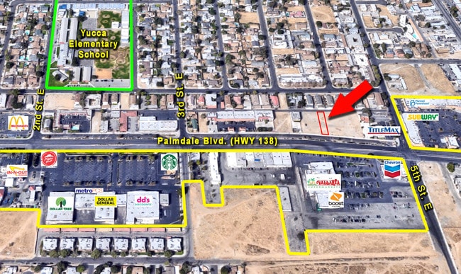
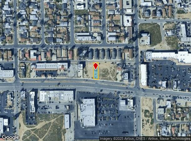
Property Record
Vac Palmdale Boulevard Vic, Palmdale, CA 93550
NEARBY LISTINGS FOR SALE OR LEASE
Property Detail
Vac Palmdale Boulevard Vic
Los Angeles-Long Beach-Glendale, CA
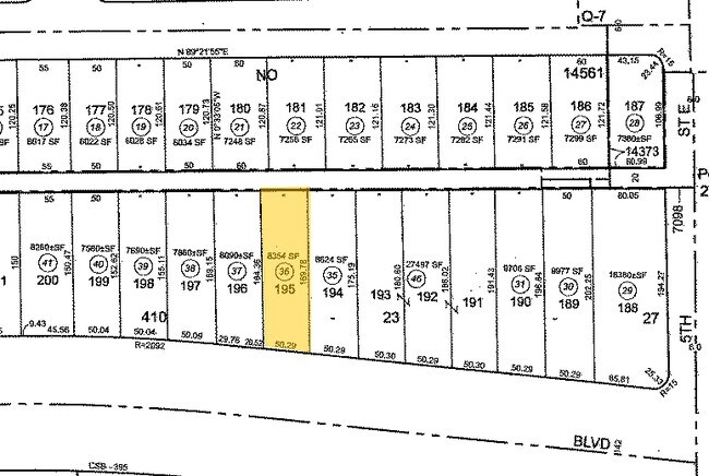
14561
3008-025-036
TRACT NO 14561 LOT 195
Commercialacreage
Los Angeles
X
California
06037C0700F
195
2024
0.19 AC
2025
Antelope Valley
910504
Los Angeles
DEMOGRAPHICS near Vac Palmdale Boulevard Vic
1 Mile
3 Mile
5 Mile
2024 Total Population
20,469
77,454
136,113
2029 Population
20,079
75,262
131,913
Pop Growth 2024-2029
(1.91%)
(2.83%)
(3.09%)
Average Age
33
35
36
2024 Total Households
6,518
23,269
39,356
HH Growth 2024-2029
(2.04%)
(2.91%)
(3.21%)
Median Household Inc
$35,891
$56,606
$67,173
Avg Household Size
3.10
3.30
3.40
2024 Avg HH Vehicles
2.00
2.00
2.00
Median Home Value
$298,386
$316,072
$337,233
Median Year Built
1982
1985
1987
Nearby Places
Map Layers
Map Styles
 Street
 Aerial
- Restaurants
- Banks
- Shops
- Fitness
- Groceries
PUBLIC TRANSPORTATION
COMMUTER RAIL
Palmdale (Antelope Valley Line - Southern California Regional Rail Authority (Metrolink))
DRIVE
WALK
Distance
Palmdale (Antelope Valley Line - Southern California Regional Rail Authority (Metrolink))
2 min
18 min
0.9 mi
Vincent Grade/Acton (Antelope Valley Line - Southern California Regional Rail Authority (Metrolink))
DRIVE
WALK
Distance
Vincent Grade/Acton (Antelope Valley Line - Southern California Regional Rail Authority (Metrolink))
11 min
6.9 mi
AIRPORT
Bob Hope
DRIVE
WALK
Distance
Bob Hope
57 min
49.6 mi
Freight Ports
Port of Long Beach
DRIVE
WALK
Distance
Port of Long Beach
100 min
86.0 mi
SALE & LEASE HISTORY
LISTING DATE
SALE/LEASE

Mar 13, 2017
For Sale
Dec 20, 2022
For Sale
Nearby Properties
Address
Land Use
TOTAL SIZE
Lot Size
Zoning
Address
Land Use
TOTAL SIZE
Lot Size
Zoning
2,861,890 SF
528.69 AC
POMA-A25*
Address
Land Use
TOTAL SIZE
Lot Size
Zoning
358,828 SF
26.23 AC
PDR17000
Address
Land Use
TOTAL SIZE
Lot Size
Zoning
449,135 SF
29.76 AC
PDRA
Address
Land Use
TOTAL SIZE
Lot Size
Zoning
130,392 SF
26.91 AC
PDCPD*
Address
Land Use
TOTAL SIZE
Lot Size
Zoning
167,366 SF
15.36 AC
PDC3
Address
Land Use
TOTAL SIZE
Lot Size
Zoning
201,615 SF
20.60 AC
PDC4
Address
Land Use
TOTAL SIZE
Lot Size
Zoning
88,750 SF
9.28 AC
PDM1 1/2*
Address
Land Use
TOTAL SIZE
Lot Size
Zoning
66,526 SF
9.12 AC
LAWC
Address
Land Use
TOTAL SIZE
Lot Size
Zoning
128,353 SF
9.49 AC
PDCPD-R1*
Address
Land Use
TOTAL SIZE
Lot Size
Zoning
50,735 SF
PDCPD
Address
Land Use
TOTAL SIZE
Lot Size
Zoning
78,492 SF
3.25 AC
PDCPD
Address
Land Use
TOTAL SIZE
Lot Size
Zoning
139,513 SF
4.07 AC
PDCPD
Address
Land Use
TOTAL SIZE
Lot Size
Zoning
60,644 SF
3.89 AC
PDMX*
Address
Land Use
TOTAL SIZE
Lot Size
Zoning
103,503 SF
3.61 AC
PDC2
Address
Land Use
TOTAL SIZE
Lot Size
Zoning
64,818 SF
2.30 AC
PDCP
Address
Land Use
TOTAL SIZE
Lot Size
Zoning
57,382 SF
2.52 AC
PDC4*
Address
Land Use
TOTAL SIZE
Lot Size
Zoning
221,827 SF
14.90 AC
PDRPD10U-R
Address
Land Use
TOTAL SIZE
Lot Size
Zoning
157,021 SF
PDRN4
Address
Land Use
TOTAL SIZE
Lot Size
Zoning
59,577 SF
0.59 AC
PDR17000
Address
Land Use
TOTAL SIZE
Lot Size
Zoning
209,328 SF
6.35 AC
PDC3-RPD15
Address
Land Use
TOTAL SIZE
Lot Size
Zoning
69,555 SF
7.55 AC
PDMPD*
Address
Land Use
TOTAL SIZE
Lot Size
Zoning
147,297 SF
10.57 AC
POC4
Address
Land Use
TOTAL SIZE
Lot Size
Zoning
68,943 SF
2.72 AC
POC4
Address
Land Use
TOTAL SIZE
Lot Size
Zoning
71,394 SF
2.93 AC
PDCPD*
Address
Land Use
TOTAL SIZE
Lot Size
Zoning
76,609 SF
3.61 AC
PDM2
Address
Land Use
TOTAL SIZE
Lot Size
Zoning
115,684 SF
10.46 AC
PDRA
Address
Land Use
TOTAL SIZE
Lot Size
Zoning
36,033 SF
3.81 AC
PDMPD*
Address
Land Use
TOTAL SIZE
Lot Size
Zoning
144,471 SF
12.96 AC
PDCPD-MPD*
Address
Land Use
TOTAL SIZE
Lot Size
Zoning
80,981 SF
7.11 AC
PDC3
The World's #1 Commercial Real Estate Marketplace
Connect with us
© 2025 CoStar Group
The information above has been obtained from sources believed reliable. While we do not doubt its accuracy we have not verified it and make no guarantee, warranty or representation about it. It is your responsibility to independently confirm its accuracy and completeness. Any projections, opinions, assumptions, or estimates used are for example only and do not represent the current or future performance of the property. The value of this transaction to you depends on tax and other factors which should be evaluated by your tax, financial, and legal advisors. You and your advisors should conduct a careful, independent investigation of the property to determine to your satisfaction the suitability of the property for your needs.