Property Record
E Parham Rd, Henrico, VA 23227
NEARBY LISTINGS FOR SALE OR LEASE
Property Detail
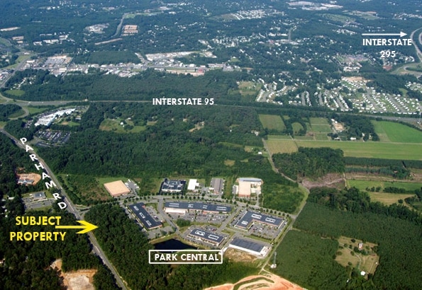
E Parham Rd
Richmond, VA
Park Central Office Complex
790-759-6085
00540A0000 0001P; PARHAM RD AC 7.264 PAR A-4 104 A2 35
Commercialacreage
Henrico
X
Virginia
51085C0320C
7.26 AC
2025
Parham East
2025
Richmond VA
200806
DEMOGRAPHICS near E Parham Rd
1 Mile
3 Mile
5 Mile
2024 Total Population
3,677
47,892
143,386
2029 Population
3,684
48,916
147,098
Pop Growth 2024-2029
+ 0.19%
+ 2.14%
+ 2.59%
Average Age
46
41
41
2024 Total Households
1,471
19,473
59,659
HH Growth 2024-2029
+ 0.20%
+ 1.91%
+ 2.59%
Median Household Inc
$82,130
$77,684
$71,919
Avg Household Size
2.50
2.40
2.30
2024 Avg HH Vehicles
3.00
2.00
2.00
Median Home Value
$254,115
$278,306
$283,329
Median Year Built
1976
1985
1977
Nearby Places
Map Layers
Map Styles
 Street
 Aerial
- Restaurants
- Banks
- Shops
- Fitness
- Groceries
PUBLIC TRANSPORTATION
COMMUTER RAIL
Richmond Staples Mill Road Amtrak Station (Carolinian - Amtrak, Northeast Regional - Amtrak, Palmetto - Amtrak, Silver Meteor - Amtrak)
DRIVE
WALK
Distance
Richmond Staples Mill Road Amtrak Station (Carolinian - Amtrak, Northeast Regional - Amtrak, Palmetto - Amtrak, Silver Meteor - Amtrak)
10 min
5.0 mi
AIRPORT
Richmond International
DRIVE
WALK
Distance
Richmond International
24 min
16.5 mi
Freight Ports
Virginia Port Authority - Richmond
DRIVE
WALK
Distance
Virginia Port Authority - Richmond
24 min
16.2 mi
Nearby Properties
Address
Land Use
TOTAL SIZE
Lot Size
Zoning
Address
Land Use
TOTAL SIZE
Lot Size
Zoning
136.01 AC
A-1
Address
Land Use
TOTAL SIZE
Lot Size
Zoning
436,148 SF
12.73 AC
B-1
Address
Land Use
TOTAL SIZE
Lot Size
Zoning
43,929 SF
46.83 AC
O-S
Address
Land Use
TOTAL SIZE
Lot Size
Zoning
32,407 SF
1.18 AC
UMU
Address
Land Use
TOTAL SIZE
Lot Size
Zoning
104,972 SF
108.49 AC
MIXE
Address
Land Use
TOTAL SIZE
Lot Size
Zoning
347,648 SF
24.75 AC
R-5
Address
Land Use
TOTAL SIZE
Lot Size
Zoning
186,034 SF
13.86 AC
B-3C
Address
Land Use
TOTAL SIZE
Lot Size
Zoning
135,874 SF
31.99 AC
MIXE
Address
Land Use
TOTAL SIZE
Lot Size
Zoning
110,790 SF
37.61 AC
R-2A
Address
Land Use
TOTAL SIZE
Lot Size
Zoning
180,070 SF
17.13 AC
R-5
Address
Land Use
TOTAL SIZE
Lot Size
Zoning
102,942 SF
71.86 AC
MIXE
Address
Land Use
TOTAL SIZE
Lot Size
Zoning
104,023 SF
98.16 AC
MIXE
Address
Land Use
TOTAL SIZE
Lot Size
Zoning
1,249,190 SF
139.90 AC
M-2
Address
Land Use
TOTAL SIZE
Lot Size
Zoning
24,165 SF
72.13 AC
C-1
Address
Land Use
TOTAL SIZE
Lot Size
Zoning
160,000 SF
25 AC
M-1
Address
Land Use
TOTAL SIZE
Lot Size
Zoning
216,900 SF
13.41 AC
R-6
Address
Land Use
TOTAL SIZE
Lot Size
Zoning
138,140 SF
7.66 AC
R-6
Address
Land Use
TOTAL SIZE
Lot Size
Zoning
114,958 SF
20 AC
R-4
Address
Land Use
TOTAL SIZE
Lot Size
Zoning
7,295 SF
72.17 AC
Address
Land Use
TOTAL SIZE
Lot Size
Zoning
112,893 SF
58.52 AC
MIXE
Address
Land Use
TOTAL SIZE
Lot Size
Zoning
228,744 SF
21.11 AC
R-5
Address
Land Use
TOTAL SIZE
Lot Size
Zoning
227,008 SF
20.94 AC
R-5
Address
Land Use
TOTAL SIZE
Lot Size
Zoning
11.06 AC
R-6
Address
Land Use
TOTAL SIZE
Lot Size
Zoning
23.23 AC
M-1
Address
Land Use
TOTAL SIZE
Lot Size
Zoning
23.60 AC
R-1
Address
Land Use
TOTAL SIZE
Lot Size
Zoning
204,358 SF
25.99 AC
B-3
Address
Land Use
TOTAL SIZE
Lot Size
Zoning
143,800 SF
11.58 AC
R-5
Address
Land Use
TOTAL SIZE
Lot Size
Zoning
33,931 SF
30.81 AC
R-3
Address
Land Use
TOTAL SIZE
Lot Size
Zoning
230,464 SF
22.76 AC
R-5
Address
Land Use
TOTAL SIZE
Lot Size
Zoning
42.30 AC
MIXE
The World's #1 Commercial Real Estate Marketplace
Connect with us
© 2025 CoStar Group
The information above has been obtained from sources believed reliable. While we do not doubt its accuracy we have not verified it and make no guarantee, warranty or representation about it. It is your responsibility to independently confirm its accuracy and completeness. Any projections, opinions, assumptions, or estimates used are for example only and do not represent the current or future performance of the property. The value of this transaction to you depends on tax and other factors which should be evaluated by your tax, financial, and legal advisors. You and your advisors should conduct a careful, independent investigation of the property to determine to your satisfaction the suitability of the property for your needs.