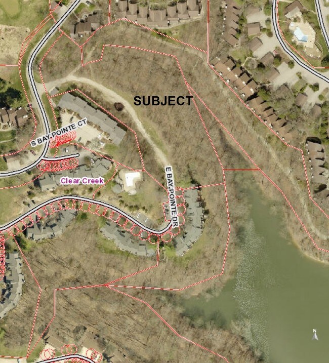
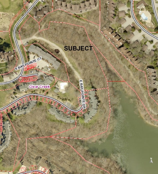
Property Record
E Pointe Rd, Bloomington, IN 47401

Save to a Folder
{{folder.Name}}
{{folder.ListingIds.length}} Properties
{{folder.ListingIds.length}} Property
Create a New Folder
Property Detail
E Pointe Rd
53-11-22-100-002.000-006
PT W2 E2 22-7-1W 2.48A
Residentialacreage
MONROE
PUD
Indiana
A Areas with a 1% annual chance of flooding and a 26% chance of flooding over the life of a 30-year mortgage.
2.48 AC
2025
Bloomington/Terre Haute
2025
Other Market Areas
001001
Bloomington, IN
NEARBY LISTINGS FOR SALE OR LEASE
-
-
View all Bloomington listings for sale on LoopNet.com
DEMOGRAPHICS near E Pointe Rd
1 mile
3 mile
5 mile
2025 Total Population
1,657
4,096
8,668
2030 Population
1,714
4,084
8,598
Pop Growth 2025-2030
+ 3.44%
(0.29%)
(0.81%)
Average Age
52
47
45
2025 Total Households
941
1,885
3,689
HH Growth 2025-2030
+ 3.72%
+ 0.32%
(0.46%)
Median Household Inc
$68,451
$73,526
$80,103
Avg Household Size
1.80
2.10
2.30
2025 Avg HH Vehicles
2.00
2.00
2.00
Median Home Value
$233,394
$266,850
$274,373
Median Year Built
1984
1984
1985
Nearby Places
Map Layers
Map Styles
 Street
 Aerial
Layers
 Traffic
 Biking
Places
Listings with unknown addresses are not visible on the map
- Restaurants
- Banks
- Shops
- Fitness
- Groceries
SALE & LEASE HISTORY
LISTING DATE
SALE/LEASE

Oct 12, 2016
For Sale
Nearby Properties
Address
Land Use
TOTAL SIZE
Lot Size
Zoning
Address
Land Use
TOTAL SIZE
Lot Size
Zoning
33,992 SF
Address
Land Use
TOTAL SIZE
Lot Size
Zoning
81,085 SF
28.19 AC
Address
Land Use
TOTAL SIZE
Lot Size
Zoning
17,105 SF
89.90 AC
PUD
Address
Land Use
TOTAL SIZE
Lot Size
Zoning
12,700 SF
3.60 AC
LB
Address
Land Use
TOTAL SIZE
Lot Size
Zoning
5,760 SF
0.80 AC
LB
Address
Land Use
TOTAL SIZE
Lot Size
Zoning
6,000 SF
5.33 AC
PB
Address
Land Use
TOTAL SIZE
Lot Size
Zoning
10,313 SF
2.91 AC
SR
Address
Land Use
TOTAL SIZE
Lot Size
Zoning
1,704 SF
10.67 AC
IP
Address
Land Use
TOTAL SIZE
Lot Size
Zoning
960 SF
139.48 AC
AGRR
Address
Land Use
TOTAL SIZE
Lot Size
Zoning
6,938 SF
3.29 AC
CR
Address
Land Use
TOTAL SIZE
Lot Size
Zoning
8,730 SF
22.42 AC
AGRR
Address
Land Use
TOTAL SIZE
Lot Size
Zoning
3,262 SF
0.52 AC
GB
Address
Land Use
TOTAL SIZE
Lot Size
Zoning
952 SF
1.38 AC
FR
Address
Land Use
TOTAL SIZE
Lot Size
Zoning
1.84 AC
FR
Address
Land Use
TOTAL SIZE
Lot Size
Zoning
1,920 SF
7.14 AC
PB
Address
Land Use
TOTAL SIZE
Lot Size
Zoning
5,628 SF
2.76 AC
PB
Address
Land Use
TOTAL SIZE
Lot Size
Zoning
5,200 SF
1.04 AC
SR
Address
Land Use
TOTAL SIZE
Lot Size
Zoning
0.51 AC
FR
Address
Land Use
TOTAL SIZE
Lot Size
Zoning
2.50 AC
WA
Address
Land Use
TOTAL SIZE
Lot Size
Zoning
2,160 SF
4 AC
GB
Address
Land Use
TOTAL SIZE
Lot Size
Zoning
17.32 AC
AGRR
Address
Land Use
TOTAL SIZE
Lot Size
Zoning
19.66 AC
AGRR
Address
Land Use
TOTAL SIZE
Lot Size
Zoning
31.33 AC
FR
Address
Land Use
TOTAL SIZE
Lot Size
Zoning
25.73 AC
AGRR
Address
Land Use
TOTAL SIZE
Lot Size
Zoning
3,168 SF
1 AC
SR
Address
Land Use
TOTAL SIZE
Lot Size
Zoning
1,152 SF
0.47 AC
PUD
Address
Land Use
TOTAL SIZE
Lot Size
Zoning
17.60 AC
AGRR
Address
Land Use
TOTAL SIZE
Lot Size
Zoning
Address
Land Use
TOTAL SIZE
Lot Size
Zoning
5,600 SF
2.50 AC
PUD
Address
Land Use
TOTAL SIZE
Lot Size
Zoning
4,800 SF
6.31 AC
PB
The World's #1 Commercial Real Estate Marketplace
Connect with us
© 2026 CoStar Group
The information above has been obtained from sources believed reliable. While we do not doubt its accuracy we have not verified it and make no guarantee, warranty or representation about it. It is your responsibility to independently confirm its accuracy and completeness. Any projections, opinions, assumptions, or estimates used are for example only and do not represent the current or future performance of the property. The value of this transaction to you depends on tax and other factors which should be evaluated by your tax, financial, and legal advisors. You and your advisors should conduct a careful, independent investigation of the property to determine to your satisfaction the suitability of the property for your needs.