Property Record
E Railroad St, Laurel, MT 59044

NEARBY LISTINGS FOR SALE OR LEASE
-
-
View all Laurel listings for sale on LoopNet.com
Property Detail
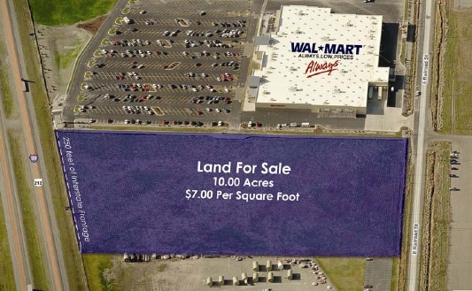
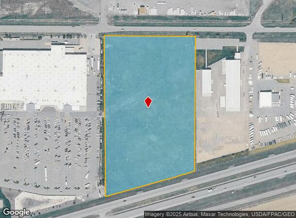
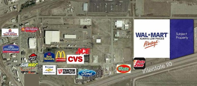
E Railroad St
Billings, MT
Entertainment Park Subd
03-0821-15-2-70-01-0000
ENTERTAINMENT PARK SUBD, S15, T02 S, R24 E, BLOCK 1, LOT 3
Commercialacreage
Yellowstone
X
Montana
30009C0020E
3
2024
10 AC
2025
Billings
001902
Other Market Areas
DEMOGRAPHICS near E Railroad St
1 Mile
3 Mile
5 Mile
2024 Total Population
3,030
10,511
12,430
2029 Population
3,285
11,313
13,412
Pop Growth 2024-2029
+ 8.42%
+ 7.63%
+ 7.90%
Average Age
39
40
41
2024 Total Households
1,284
4,188
4,891
HH Growth 2024-2029
+ 8.49%
+ 7.81%
+ 8.06%
Median Household Inc
$66,174
$76,119
$79,629
Avg Household Size
2.30
2.50
2.50
2024 Avg HH Vehicles
2.00
2.00
2.00
Median Home Value
$179,252
$268,181
$290,885
Median Year Built
1972
1977
1979
Nearby Places
Map Layers
Map Styles
 Street
 Aerial
- Restaurants
- Banks
- Shops
- Fitness
- Groceries
PUBLIC TRANSPORTATION
AIRPORT
Billings Logan International
DRIVE
WALK
Distance
Billings Logan International
42 min
21.8 mi
SALE & LEASE HISTORY
LISTING DATE
SALE/LEASE

Sep 24, 2016
For Sale
Jan 07, 2021
For Sale
Nearby Properties
Address
Land Use
TOTAL SIZE
Lot Size
Zoning
Address
Land Use
TOTAL SIZE
Lot Size
Zoning
385,001 SF
102.22 AC
7
Address
Land Use
TOTAL SIZE
Lot Size
Zoning
158,130 SF
16.11 AC
Address
Land Use
TOTAL SIZE
Lot Size
Zoning
86,116 SF
12.07 AC
1
Address
Land Use
TOTAL SIZE
Lot Size
Zoning
110,231 SF
10 AC
Address
Land Use
TOTAL SIZE
Lot Size
Zoning
4.49 AC
Address
Land Use
TOTAL SIZE
Lot Size
Zoning
44,280 SF
4.90 AC
1
Address
Land Use
TOTAL SIZE
Lot Size
Zoning
23,968 SF
202.67 AC
6
Address
Land Use
TOTAL SIZE
Lot Size
Zoning
39,379 SF
3.90 AC
Address
Land Use
TOTAL SIZE
Lot Size
Zoning
4,560 SF
12.57 AC
Address
Land Use
TOTAL SIZE
Lot Size
Zoning
24,610 SF
2.17 AC
HC
Address
Land Use
TOTAL SIZE
Lot Size
Zoning
36,976 SF
7.63 AC
P
Address
Land Use
TOTAL SIZE
Lot Size
Zoning
94.51 AC
Address
Land Use
TOTAL SIZE
Lot Size
Zoning
29,919 SF
1.74 AC
Address
Land Use
TOTAL SIZE
Lot Size
Zoning
59,050 SF
2.07 AC
R6000
Address
Land Use
TOTAL SIZE
Lot Size
Zoning
33,654 SF
5.27 AC
P
Address
Land Use
TOTAL SIZE
Lot Size
Zoning
7.54 AC
P
Address
Land Use
TOTAL SIZE
Lot Size
Zoning
35,795 SF
2.34 AC
Address
Land Use
TOTAL SIZE
Lot Size
Zoning
62,000 SF
21.59 AC
7
Address
Land Use
TOTAL SIZE
Lot Size
Zoning
90,348 SF
9.50 AC
HC
Address
Land Use
TOTAL SIZE
Lot Size
Zoning
73,148 SF
3.29 AC
Address
Land Use
TOTAL SIZE
Lot Size
Zoning
28,540 SF
6.03 AC
Address
Land Use
TOTAL SIZE
Lot Size
Zoning
15.39 AC
Address
Land Use
TOTAL SIZE
Lot Size
Zoning
21,317 SF
0.51 AC
Address
Land Use
TOTAL SIZE
Lot Size
Zoning
109,301 SF
19.12 AC
7
Address
Land Use
TOTAL SIZE
Lot Size
Zoning
12,311 SF
4 AC
8
Address
Land Use
TOTAL SIZE
Lot Size
Zoning
14,208 SF
0.81 AC
Address
Land Use
TOTAL SIZE
Lot Size
Zoning
15,882 SF
7.74 AC
Address
Land Use
TOTAL SIZE
Lot Size
Zoning
30,345 SF
2.55 AC
HC
Address
Land Use
TOTAL SIZE
Lot Size
Zoning
33,200 SF
5 AC
Address
Land Use
TOTAL SIZE
Lot Size
Zoning
21,757 SF
3.09 AC
The World's #1 Commercial Real Estate Marketplace
Connect with us
© 2025 CoStar Group
The information above has been obtained from sources believed reliable. While we do not doubt its accuracy we have not verified it and make no guarantee, warranty or representation about it. It is your responsibility to independently confirm its accuracy and completeness. Any projections, opinions, assumptions, or estimates used are for example only and do not represent the current or future performance of the property. The value of this transaction to you depends on tax and other factors which should be evaluated by your tax, financial, and legal advisors. You and your advisors should conduct a careful, independent investigation of the property to determine to your satisfaction the suitability of the property for your needs.