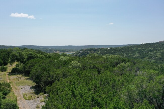
Property Record
E Reed Parks Rd, Leander, TX 78645
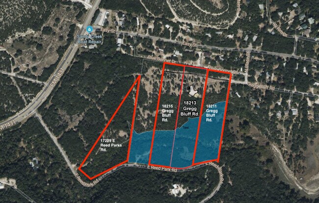
Property Detail
E Reed Parks Rd
Austin-Round Rock-San Marcos, TX
ABS 325 SUR 603 GREGG J ACR 12.0523
963298
TRAVIS
Farms
Texas
2025
5.11 AC
2025
Far Northwest
037600
Austin
4,750 SF
NEARBY LISTINGS FOR SALE OR LEASE
DEMOGRAPHICS near E Reed Parks Rd
1 mile
3 mile
5 mile
2025 Total Population
1,390
6,683
42,558
2030 Population
1,487
7,202
45,836
Pop Growth 2025-2030
+ 6.98%
+ 7.77%
+ 7.70%
Average Age
48
48
42
2025 Total Households
584
2,758
15,267
HH Growth 2025-2030
+ 7.53%
+ 8.41%
+ 8.33%
Median Household Inc
$113,825
$110,623
$157,004
Avg Household Size
2.40
2.40
2.80
2025 Avg HH Vehicles
3.00
2.00
2.00
Median Home Value
$729,899
$715,252
$684,736
Median Year Built
2002
2002
2006
Nearby Places
Map Layers
Map Styles
 Street
 Aerial
Transit
 Traffic
 Biking
Places
Listings with unknown addresses are not visible on the map
- Restaurants
- Banks
- Shops
- Fitness
- Groceries
PUBLIC TRANSPORTATION
AIRPORT
Austin-Bergstrom International
Drive
Walk
Distance
Austin-Bergstrom International
60 min
41.1 mi
Freight Ports
Calhoun Port
Drive
Walk
Distance
Calhoun Port
225 min
184.6 mi
Nearby Properties
Address
Land Use
TOTAL SIZE
Lot Size
Zoning
Address
Land Use
TOTAL SIZE
Lot Size
Zoning
2,327 SF
810.41 AC
Address
Land Use
TOTAL SIZE
Lot Size
Zoning
673.44 AC
Address
Land Use
TOTAL SIZE
Lot Size
Zoning
670.57 AC
Address
Land Use
TOTAL SIZE
Lot Size
Zoning
2,366 SF
6.68 AC
Address
Land Use
TOTAL SIZE
Lot Size
Zoning
69,163 SF
4.42 AC
Address
Land Use
TOTAL SIZE
Lot Size
Zoning
92,252 SF
10.12 AC
Address
Land Use
TOTAL SIZE
Lot Size
Zoning
14,351 SF
2.74 AC
Address
Land Use
TOTAL SIZE
Lot Size
Zoning
2,744 SF
299.90 AC
Address
Land Use
TOTAL SIZE
Lot Size
Zoning
560 SF
38.01 AC
Address
Land Use
TOTAL SIZE
Lot Size
Zoning
17,596 SF
2.15 AC
Address
Land Use
TOTAL SIZE
Lot Size
Zoning
13,714 SF
30.56 AC
Address
Land Use
TOTAL SIZE
Lot Size
Zoning
584.77 AC
Address
Land Use
TOTAL SIZE
Lot Size
Zoning
46,955 SF
3.09 AC
Address
Land Use
TOTAL SIZE
Lot Size
Zoning
107.45 AC
Address
Land Use
TOTAL SIZE
Lot Size
Zoning
2,780 SF
2.76 AC
Address
Land Use
TOTAL SIZE
Lot Size
Zoning
26.88 AC
Address
Land Use
TOTAL SIZE
Lot Size
Zoning
7.71 AC
Address
Land Use
TOTAL SIZE
Lot Size
Zoning
5.48 AC
Address
Land Use
TOTAL SIZE
Lot Size
Zoning
3.07 AC
Address
Land Use
TOTAL SIZE
Lot Size
Zoning
138.92 AC
Address
Land Use
TOTAL SIZE
Lot Size
Zoning
3.50 AC
Address
Land Use
TOTAL SIZE
Lot Size
Zoning
107.31 AC
Address
Land Use
TOTAL SIZE
Lot Size
Zoning
7,045 SF
1.19 AC
Address
Land Use
TOTAL SIZE
Lot Size
Zoning
4,834 SF
7.18 AC
Address
Land Use
TOTAL SIZE
Lot Size
Zoning
62.62 AC
Address
Land Use
TOTAL SIZE
Lot Size
Zoning
13,000 SF
1.60 AC
Address
Land Use
TOTAL SIZE
Lot Size
Zoning
3,289 SF
6.48 AC
Address
Land Use
TOTAL SIZE
Lot Size
Zoning
8,692 SF
3.52 AC
Address
Land Use
TOTAL SIZE
Lot Size
Zoning
2,815 SF
51.09 AC
Address
Land Use
TOTAL SIZE
Lot Size
Zoning
1 SF
14.37 AC
The World's #1 Commercial Real Estate Marketplace
Connect with us
© 2026 CoStar Group
The information above has been obtained from sources believed reliable. While we do not doubt its accuracy we have not verified it and make no guarantee, warranty or representation about it. It is your responsibility to independently confirm its accuracy and completeness. Any projections, opinions, assumptions, or estimates used are for example only and do not represent the current or future performance of the property. The value of this transaction to you depends on tax and other factors which should be evaluated by your tax, financial, and legal advisors. You and your advisors should conduct a careful, independent investigation of the property to determine to your satisfaction the suitability of the property for your needs.