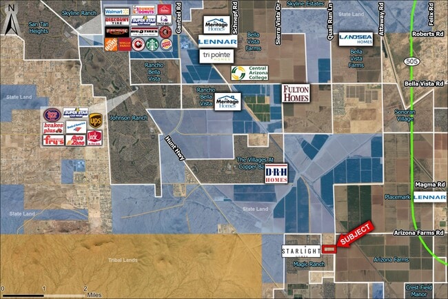
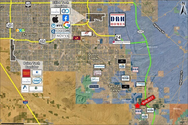
Property Record
E Renfroe Way, Florence, AZ 85132
Property Detail
E Renfroe Way
200-58-008J
S1/2 E1/2 N1/2 OF PARCEL 8 MAGMA BUTTE RANCHES BK 1 PG 45 SEC 2-4 S-8E 4.97 AC
Vacantlandnec
PINAL
GR
Arizona
B and X Area of moderate flood hazard, usually the area between the limits of the 100-year and 500-year floods.
14.91 AC
2024
Pinal County
2025
Phoenix
000804
Phoenix-Mesa-Chandler, AZ
NEARBY LISTINGS FOR SALE OR LEASE
DEMOGRAPHICS near E Renfroe Way
1 mile
3 mile
5 mile
2025 Total Population
1,303
17,876
57,161
2030 Population
1,558
21,109
67,696
Pop Growth 2025-2030
+ 19.57%
+ 18.09%
+ 18.43%
Average Age
34
35
39
2025 Total Households
381
5,450
18,843
HH Growth 2025-2030
+ 19.42%
+ 18.04%
+ 18.52%
Median Household Inc
$81,579
$81,011
$88,917
Avg Household Size
3.20
3.20
3.00
2025 Avg HH Vehicles
3.00
2.00
2.00
Median Home Value
$339,767
$354,853
$387,172
Median Year Built
2008
2007
2008
Nearby Places
Map Layers
Map Styles
 Street
 Aerial
Layers
 Traffic
 Biking
Places
Listings with unknown addresses are not visible on the map
- Restaurants
- Banks
- Shops
- Fitness
- Groceries
PUBLIC TRANSPORTATION
AIRPORT
Phoenix-Mesa Gateway
Drive
Walk
Distance
Phoenix-Mesa Gateway
33 min
19.3 mi
Freight Ports
Port of San Diego
Drive
Walk
Distance
Port of San Diego
425 min
382.2 mi
SALE & LEASE HISTORY
LISTING DATE
SALE/LEASE

Sep 12, 2024
For Sale
Nearby Properties
Address
Land Use
TOTAL SIZE
Lot Size
Zoning
Address
Land Use
TOTAL SIZE
Lot Size
Zoning
73,818 SF
5.70 AC
Address
Land Use
TOTAL SIZE
Lot Size
Zoning
12.50 AC
Address
Land Use
TOTAL SIZE
Lot Size
Zoning
97,827 SF
6.45 AC
Address
Land Use
TOTAL SIZE
Lot Size
Zoning
62,436 SF
6.52 AC
Address
Land Use
TOTAL SIZE
Lot Size
Zoning
100,700 SF
6.63 AC
CB2
Address
Land Use
TOTAL SIZE
Lot Size
Zoning
22,942 SF
6.32 AC
Address
Land Use
TOTAL SIZE
Lot Size
Zoning
61,180 SF
19.61 AC
CB1
Address
Land Use
TOTAL SIZE
Lot Size
Zoning
11,976 SF
17.47 AC
Address
Land Use
TOTAL SIZE
Lot Size
Zoning
39.83 AC
Address
Land Use
TOTAL SIZE
Lot Size
Zoning
14,723 SF
39.24 AC
GR
Address
Land Use
TOTAL SIZE
Lot Size
Zoning
11,057 SF
5.05 AC
Address
Land Use
TOTAL SIZE
Lot Size
Zoning
6,386 SF
1.26 AC
Address
Land Use
TOTAL SIZE
Lot Size
Zoning
28,800 SF
2.04 AC
CB2
Address
Land Use
TOTAL SIZE
Lot Size
Zoning
14,450 SF
3.31 AC
CI2
Address
Land Use
TOTAL SIZE
Lot Size
Zoning
18.83 AC
UNDESIGNAT
Address
Land Use
TOTAL SIZE
Lot Size
Zoning
5,060 SF
1.22 AC
CI1
Address
Land Use
TOTAL SIZE
Lot Size
Zoning
156.92 AC
CR3
Address
Land Use
TOTAL SIZE
Lot Size
Zoning
5,732 SF
639.08 AC
UNDESIGNAT
Address
Land Use
TOTAL SIZE
Lot Size
Zoning
5,000 SF
2.50 AC
GR
Address
Land Use
TOTAL SIZE
Lot Size
Zoning
33,600 SF
4.62 AC
CI1
Address
Land Use
TOTAL SIZE
Lot Size
Zoning
4,324 SF
23.51 AC
GR
Address
Land Use
TOTAL SIZE
Lot Size
Zoning
6.02 AC
UNDESIGNAT
Address
Land Use
TOTAL SIZE
Lot Size
Zoning
14.85 AC
GR
Address
Land Use
TOTAL SIZE
Lot Size
Zoning
10.20 AC
Address
Land Use
TOTAL SIZE
Lot Size
Zoning
10.02 AC
Address
Land Use
TOTAL SIZE
Lot Size
Zoning
9.94 AC
GR
Address
Land Use
TOTAL SIZE
Lot Size
Zoning
2,767 SF
398.40 AC
UNDESIGNAT
The World's #1 Commercial Real Estate Marketplace
Connect with us
© 2026 CoStar Group
The information above has been obtained from sources believed reliable. While we do not doubt its accuracy we have not verified it and make no guarantee, warranty or representation about it. It is your responsibility to independently confirm its accuracy and completeness. Any projections, opinions, assumptions, or estimates used are for example only and do not represent the current or future performance of the property. The value of this transaction to you depends on tax and other factors which should be evaluated by your tax, financial, and legal advisors. You and your advisors should conduct a careful, independent investigation of the property to determine to your satisfaction the suitability of the property for your needs.