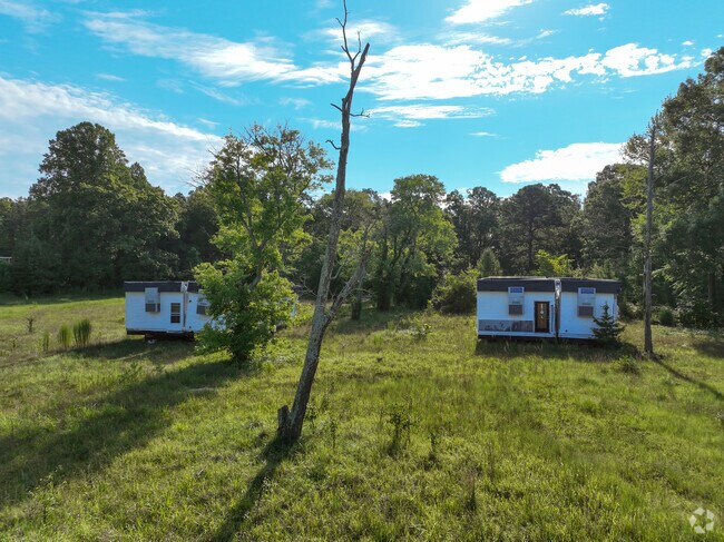
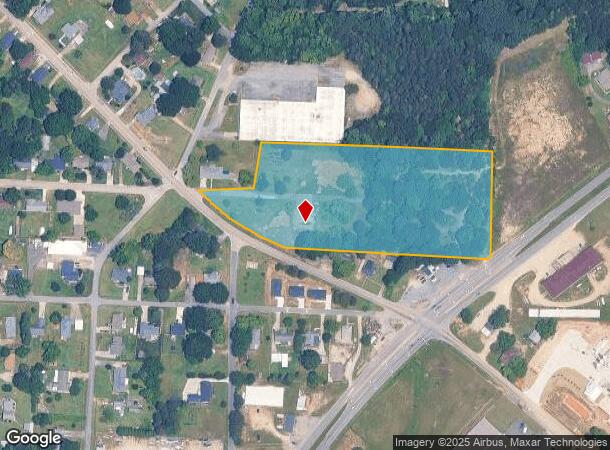
Property Record
E Ryder Ave, China Grove, NC 28023

NEARBY LISTINGS FOR SALE OR LEASE
Property Detail
E Ryder Ave
Charlotte-Concord-Gastonia, NC-SC
Don Bare
133-165
5.99AC
Industrialacreage
Rowan
X
North Carolina
3710562500K
5.99 AC
2025
Rowan County
2025
Charlotte
051700
DEMOGRAPHICS near E Ryder Ave
1 mile
3 mile
5 mile
2024 Total Population
3,770
25,966
63,437
2029 Population
3,979
27,628
69,233
Pop Growth 2024-2029
+ 5.54%
+ 6.40%
+ 9.14%
Average Age
40
39
39
2024 Total Households
1,517
10,172
24,748
HH Growth 2024-2029
+ 5.47%
+ 6.25%
+ 8.52%
Median Household Inc
$66,475
$55,227
$55,068
Avg Household Size
2.50
2.50
2.50
2024 Avg HH Vehicles
2.00
2.00
2.00
Median Home Value
$219,886
$166,308
$173,885
Median Year Built
1977
1975
1977
Nearby Places
Map Layers
Map Styles
 Street
 Aerial
Transit
 Traffic
 Biking
Places
Listings with unknown addresses are not visible on the map
- Restaurants
- Banks
- Shops
- Fitness
- Groceries
PUBLIC TRANSPORTATION
COMMUTER RAIL
Kannapolis Station (Piedmont - North Carolina by Train (NC Train))
Drive
Walk
Distance
Kannapolis Station (Piedmont - North Carolina by Train (NC Train))
7 min
4.0 mi
AIRPORT
Concord-Padgett Regional
Drive
Walk
Distance
Concord-Padgett Regional
26 min
16.3 mi
Charlotte/Douglas International
Drive
Walk
Distance
Charlotte/Douglas International
51 min
36.5 mi
Freight Ports
Port of Wilmington
Drive
Walk
Distance
Port of Wilmington
266 min
205.6 mi
Nearby Properties
Address
Land Use
TOTAL SIZE
Lot Size
Zoning
Address
Land Use
TOTAL SIZE
Lot Size
Zoning
728,000 SF
51.80 AC
Address
Land Use
TOTAL SIZE
Lot Size
Zoning
67,862 SF
1.77 AC
CC
Address
Land Use
TOTAL SIZE
Lot Size
Zoning
55,888 SF
39.43 AC
Address
Land Use
TOTAL SIZE
Lot Size
Zoning
56,923 SF
2 AC
CC
Address
Land Use
TOTAL SIZE
Lot Size
Zoning
269,700 SF
76.24 AC
Address
Land Use
TOTAL SIZE
Lot Size
Zoning
50,366 SF
1.64 AC
CC
Address
Land Use
TOTAL SIZE
Lot Size
Zoning
35,850 SF
34 AC
Address
Land Use
TOTAL SIZE
Lot Size
Zoning
83,701 SF
2.99 AC
R4
Address
Land Use
TOTAL SIZE
Lot Size
Zoning
21,906 SF
7.50 AC
OI:OFFICE
Address
Land Use
TOTAL SIZE
Lot Size
Zoning
37,300 SF
20.95 AC
RM2:MULTI
Address
Land Use
TOTAL SIZE
Lot Size
Zoning
39.58 AC
CC
Address
Land Use
TOTAL SIZE
Lot Size
Zoning
44,149 SF
11.26 AC
Address
Land Use
TOTAL SIZE
Lot Size
Zoning
72,726 SF
7.14 AC
GC
Address
Land Use
TOTAL SIZE
Lot Size
Zoning
146,346 SF
16.39 AC
Address
Land Use
TOTAL SIZE
Lot Size
Zoning
34,288 SF
5.61 AC
O-I
Address
Land Use
TOTAL SIZE
Lot Size
Zoning
14,258 SF
137.98 AC
RM1:MULTI
Address
Land Use
TOTAL SIZE
Lot Size
Zoning
58,300 SF
14.53 AC
R8:SINGLE
Address
Land Use
TOTAL SIZE
Lot Size
Zoning
19,951 SF
9.12 AC
OI:OFFICE
Address
Land Use
TOTAL SIZE
Lot Size
Zoning
43,091 SF
21.39 AC
Address
Land Use
TOTAL SIZE
Lot Size
Zoning
139,812 SF
17.35 AC
Address
Land Use
TOTAL SIZE
Lot Size
Zoning
99.27 AC
Address
Land Use
TOTAL SIZE
Lot Size
Zoning
1,960 SF
44.11 AC
R4:SINGLE
Address
Land Use
TOTAL SIZE
Lot Size
Zoning
8,941 SF
2.36 AC
Address
Land Use
TOTAL SIZE
Lot Size
Zoning
1,640 SF
21.46 AC
Address
Land Use
TOTAL SIZE
Lot Size
Zoning
13,770 SF
1.28 AC
GC
Address
Land Use
TOTAL SIZE
Lot Size
Zoning
30,284 SF
12.51 AC
Address
Land Use
TOTAL SIZE
Lot Size
Zoning
45,450 SF
5.01 AC
C2:HIGHWAY
Address
Land Use
TOTAL SIZE
Lot Size
Zoning
3,200 SF
259.49 AC
Address
Land Use
TOTAL SIZE
Lot Size
Zoning
17,259 SF
0.90 AC
Address
Land Use
TOTAL SIZE
Lot Size
Zoning
23,926 SF
4.70 AC
The World's #1 Commercial Real Estate Marketplace
Connect with us
© 2026 CoStar Group
The information above has been obtained from sources believed reliable. While we do not doubt its accuracy we have not verified it and make no guarantee, warranty or representation about it. It is your responsibility to independently confirm its accuracy and completeness. Any projections, opinions, assumptions, or estimates used are for example only and do not represent the current or future performance of the property. The value of this transaction to you depends on tax and other factors which should be evaluated by your tax, financial, and legal advisors. You and your advisors should conduct a careful, independent investigation of the property to determine to your satisfaction the suitability of the property for your needs.