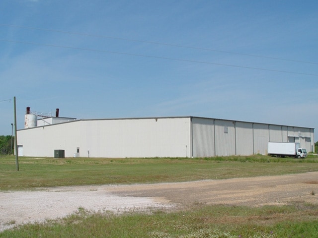
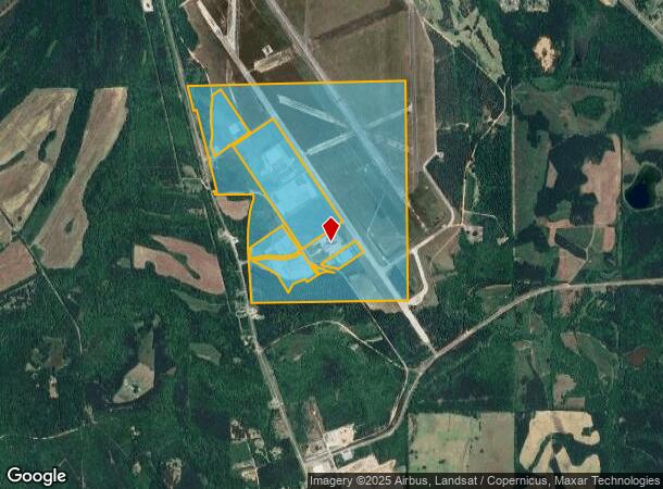
Property Record
E S State Highway 41, Selma, AL 36701
NEARBY LISTINGS FOR SALE OR LEASE
Property Detail
E S State Highway 41
15-09-29-0-000-001.0000
Craig Field S/D
Vacantlandnec
400.61AC - PT PARCEL 3-AA CRAIG FIELD S/D PLAT# 2 DB 899 PG 134 DB 1305 PG 316
X
Dallas
01047C0355E
Alabama
0
400.61 AC
2024
Alabama South Area
956600
Other Market Areas
82,896 SF
Selma, AL
DEMOGRAPHICS near E S State Highway 41
1 Mile
3 Mile
5 Mile
2024 Total Population
17
3,399
6,948
2029 Population
16
3,250
6,672
Pop Growth 2024-2029
(5.88%)
(4.38%)
(3.97%)
Average Age
40
41
41
2024 Total Households
7
1,365
2,857
HH Growth 2024-2029
(14.29%)
(3.66%)
(3.26%)
Median Household Inc
$23,749
$28,702
$32,016
Avg Household Size
2.20
2.40
2.40
2024 Avg HH Vehicles
1.00
2.00
2.00
Median Home Value
$50,000
$71,329
$69,664
Median Year Built
1969
1975
1974
Nearby Places
Map Layers
Map Styles
 Street
 Aerial
- Restaurants
- Banks
- Shops
- Fitness
- Groceries
SALE & LEASE HISTORY
LISTING DATE
SALE/LEASE

Sep 25, 2016
For Lease
Sep 24, 2016
For Sale
Oct 26, 2021
For Sale
Mar 03, 2022
For Lease
Nearby Properties
Address
Land Use
TOTAL SIZE
Lot Size
Zoning
Address
Land Use
TOTAL SIZE
Lot Size
Zoning
82,896 SF
40 AC
O
Address
Land Use
TOTAL SIZE
Lot Size
Zoning
276,190 SF
40 AC
C
Address
Land Use
TOTAL SIZE
Lot Size
Zoning
100,410 SF
22.11 AC
I
Address
Land Use
TOTAL SIZE
Lot Size
Zoning
57,340 SF
11.98 AC
Address
Land Use
TOTAL SIZE
Lot Size
Zoning
7,840 SF
6 AC
Address
Land Use
TOTAL SIZE
Lot Size
Zoning
72,020 SF
14.35 AC
Address
Land Use
TOTAL SIZE
Lot Size
Zoning
5,103 SF
5.25 AC
Address
Land Use
TOTAL SIZE
Lot Size
Zoning
31,500 SF
5.71 AC
O
Address
Land Use
TOTAL SIZE
Lot Size
Zoning
48,712 SF
5.17 AC
Address
Land Use
TOTAL SIZE
Lot Size
Zoning
25,051 SF
12.96 AC
Address
Land Use
TOTAL SIZE
Lot Size
Zoning
16,230 SF
10.90 AC
Address
Land Use
TOTAL SIZE
Lot Size
Zoning
3,038 SF
3.84 AC
C
Address
Land Use
TOTAL SIZE
Lot Size
Zoning
13,106 SF
5 AC
O
Address
Land Use
TOTAL SIZE
Lot Size
Zoning
2,232 SF
7.32 AC
I
Address
Land Use
TOTAL SIZE
Lot Size
Zoning
7,606 SF
2.80 AC
S
Address
Land Use
TOTAL SIZE
Lot Size
Zoning
18,000 SF
2.53 AC
S
Address
Land Use
TOTAL SIZE
Lot Size
Zoning
13,468 SF
7.19 AC
O
Address
Land Use
TOTAL SIZE
Lot Size
Zoning
18,388 SF
5 AC
Address
Land Use
TOTAL SIZE
Lot Size
Zoning
15,163 SF
3.18 AC
C
Address
Land Use
TOTAL SIZE
Lot Size
Zoning
1,611 SF
2.83 AC
C
Address
Land Use
TOTAL SIZE
Lot Size
Zoning
6,043 SF
0.92 AC
C
Address
Land Use
TOTAL SIZE
Lot Size
Zoning
3,424 SF
5.75 AC
Address
Land Use
TOTAL SIZE
Lot Size
Zoning
55,542 SF
20.66 AC
O
Address
Land Use
TOTAL SIZE
Lot Size
Zoning
9,410 SF
4.25 AC
N
Address
Land Use
TOTAL SIZE
Lot Size
Zoning
0.50 AC
R-10
Address
Land Use
TOTAL SIZE
Lot Size
Zoning
4,150 SF
0.52 AC
C
Address
Land Use
TOTAL SIZE
Lot Size
Zoning
4,821 SF
1.70 AC
O
Address
Land Use
TOTAL SIZE
Lot Size
Zoning
8,000 SF
2 AC
O
The World's #1 Commercial Real Estate Marketplace
Connect with us
© 2025 CoStar Group
The information above has been obtained from sources believed reliable. While we do not doubt its accuracy we have not verified it and make no guarantee, warranty or representation about it. It is your responsibility to independently confirm its accuracy and completeness. Any projections, opinions, assumptions, or estimates used are for example only and do not represent the current or future performance of the property. The value of this transaction to you depends on tax and other factors which should be evaluated by your tax, financial, and legal advisors. You and your advisors should conduct a careful, independent investigation of the property to determine to your satisfaction the suitability of the property for your needs.