Property Record
E Side Hwy, Waynesboro, VA 22980

Save to a Folder
{{folder.Name}}
{{folder.ListingIds.length}} Properties
{{folder.ListingIds.length}} Property
Create a New Folder
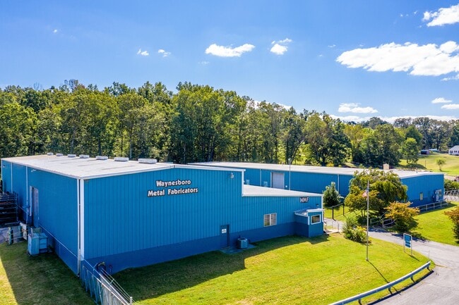
This Property Is For Sale
Current Lease Availabilities
Property Detail
E Side Hwy
068-144
68-144 N WAYNESBORO ON RT 340 4.747 ACS
Manufacturinglight
AUGUSTA
GENERAL IN
Virginia
B and X Area of moderate flood hazard, usually the area between the limits of the 100-year and 500-year floods.
4.75 AC
2026
Staunton & Harrisonburg
2026
Other Market Areas
003400
Staunton-Stuarts Draft, VA
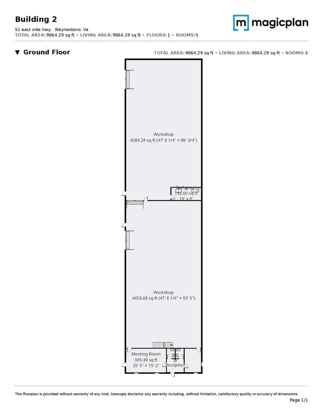
14,746 SF
NEARBY LISTINGS FOR SALE OR LEASE
DEMOGRAPHICS near E Side Hwy
1 mile
3 mile
5 mile
2025 Total Population
1,386
19,354
32,181
2030 Population
1,428
20,168
33,424
Pop Growth 2025-2030
+ 3.03%
+ 4.21%
+ 3.86%
Average Age
42
41
43
2025 Total Households
594
8,256
13,685
HH Growth 2025-2030
+ 3.03%
+ 4.28%
+ 3.94%
Median Household Inc
$57,278
$57,865
$60,847
Avg Household Size
2.30
2.30
2.30
2025 Avg HH Vehicles
2.00
2.00
2.00
Median Home Value
$236,094
$248,779
$270,096
Median Year Built
1980
1978
1978
Nearby Places
Map Layers
Map Styles
 Street
 Aerial
Layers
 Traffic
 Biking
Places
Listings with unknown addresses are not visible on the map
- Restaurants
- Banks
- Shops
- Fitness
- Groceries
PUBLIC TRANSPORTATION
AIRPORT
Charlottesville-Albemarle
Drive
Walk
Distance
Charlottesville-Albemarle
52 min
35.8 mi
Nearby Properties
Address
Land Use
TOTAL SIZE
Lot Size
Zoning
Address
Land Use
TOTAL SIZE
Lot Size
Zoning
150,944 SF
22.24 AC
RG-5
Address
Land Use
TOTAL SIZE
Lot Size
Zoning
165,670 SF
5.31 AC
R-O
Address
Land Use
TOTAL SIZE
Lot Size
Zoning
94,535 SF
40.68 AC
GENERAL AG
Address
Land Use
TOTAL SIZE
Lot Size
Zoning
48,888 SF
9.01 AC
RG-5
Address
Land Use
TOTAL SIZE
Lot Size
Zoning
121,275 SF
18.39 AC
RG-5
Address
Land Use
TOTAL SIZE
Lot Size
Zoning
947 SF
13.62 AC
RG-5
Address
Land Use
TOTAL SIZE
Lot Size
Zoning
5,624 SF
74.80 AC
H-I
Address
Land Use
TOTAL SIZE
Lot Size
Zoning
460 SF
144.09 AC
H-I
Address
Land Use
TOTAL SIZE
Lot Size
Zoning
7,512 SF
6.39 AC
R-MF
Address
Land Use
TOTAL SIZE
Lot Size
Zoning
1,844 SF
8.39 AC
R-MF
Address
Land Use
TOTAL SIZE
Lot Size
Zoning
2,460 SF
31.78 AC
PUD
Address
Land Use
TOTAL SIZE
Lot Size
Zoning
840 SF
1.70 AC
C-B
Address
Land Use
TOTAL SIZE
Lot Size
Zoning
41,574 SF
5.29 AC
H-B
Address
Land Use
TOTAL SIZE
Lot Size
Zoning
2,393 SF
6.81 AC
R-MF
Address
Land Use
TOTAL SIZE
Lot Size
Zoning
62,626 SF
1.15 AC
R-MF
Address
Land Use
TOTAL SIZE
Lot Size
Zoning
36,698 SF
0.90 AC
R-MF
Address
Land Use
TOTAL SIZE
Lot Size
Zoning
1,000 SF
4.17 AC
H-B
Address
Land Use
TOTAL SIZE
Lot Size
Zoning
42,122 SF
8 AC
RG-5
Address
Land Use
TOTAL SIZE
Lot Size
Zoning
106,752 SF
7.76 AC
H-I
Address
Land Use
TOTAL SIZE
Lot Size
Zoning
301,313 SF
55.86 AC
H-I
Address
Land Use
TOTAL SIZE
Lot Size
Zoning
18,730 SF
2.43 AC
L-I
Address
Land Use
TOTAL SIZE
Lot Size
Zoning
4,096 SF
2.24 AC
RG-5
Address
Land Use
TOTAL SIZE
Lot Size
Zoning
14,263 SF
0.48 AC
C-B
Address
Land Use
TOTAL SIZE
Lot Size
Zoning
93,866 SF
13.15 AC
H-B
Address
Land Use
TOTAL SIZE
Lot Size
Zoning
89,786 SF
6 AC
MX-B
Address
Land Use
TOTAL SIZE
Lot Size
Zoning
54.79 AC
RS-12
Address
Land Use
TOTAL SIZE
Lot Size
Zoning
13,641 SF
3.12 AC
R-MF
Address
Land Use
TOTAL SIZE
Lot Size
Zoning
20,998 SF
0.55 AC
C-B
Address
Land Use
TOTAL SIZE
Lot Size
Zoning
264,949 SF
12.04 AC
H-I
Address
Land Use
TOTAL SIZE
Lot Size
Zoning
64,572 SF
2.98 AC
R-MF
The World's #1 Commercial Real Estate Marketplace
Connect with us
© 2026 CoStar Group
The information above has been obtained from sources believed reliable. While we do not doubt its accuracy we have not verified it and make no guarantee, warranty or representation about it. It is your responsibility to independently confirm its accuracy and completeness. Any projections, opinions, assumptions, or estimates used are for example only and do not represent the current or future performance of the property. The value of this transaction to you depends on tax and other factors which should be evaluated by your tax, financial, and legal advisors. You and your advisors should conduct a careful, independent investigation of the property to determine to your satisfaction the suitability of the property for your needs.