Property Record
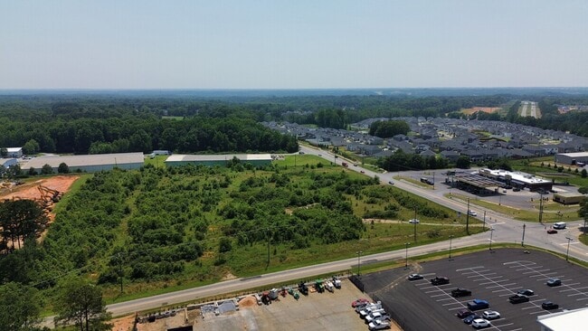
Neely Ferry Rd, Simpsonville, SC 29680

NEARBY LISTINGS FOR SALE OR LEASE
Property Detail
Neely Ferry Rd
Greenville-Anderson-Mauldin, SC
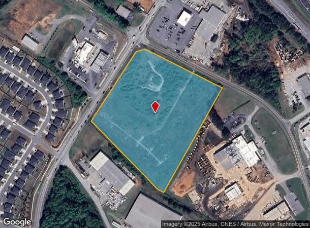
Boundary Survey For John Cox
0573.01-01-013.01
STANDING SPRINGS RD
Commercialnec
Greenville
X
South Carolina
45045C0418E
013.01
2025
9.40 AC
2024
Mauldin/Fountain
003017
Greenville/Spartanburg
2,372 SF
DEMOGRAPHICS near Neely Ferry Rd
1 Mile
3 Mile
5 Mile
2024 Total Population
2,542
53,917
125,336
2029 Population
2,858
59,475
138,693
Pop Growth 2024-2029
+ 12.43%
+ 10.31%
+ 10.66%
Average Age
41
40
39
2024 Total Households
1,017
21,335
49,057
HH Growth 2024-2029
+ 12.59%
+ 10.37%
+ 10.79%
Median Household Inc
$83,881
$79,533
$83,064
Avg Household Size
2.50
2.50
2.50
2024 Avg HH Vehicles
2.00
2.00
2.00
Median Home Value
$230,866
$232,617
$248,514
Median Year Built
1999
1995
1999
Nearby Places
Map Layers
Map Styles
 Street
 Aerial
- Restaurants
- Banks
- Shops
- Fitness
- Groceries
PUBLIC TRANSPORTATION
AIRPORT
Greenville Spartanburg International
DRIVE
WALK
Distance
Greenville Spartanburg International
20 min
13.5 mi
Freight Ports
North Charleston Terminal
DRIVE
WALK
Distance
North Charleston Terminal
214 min
192.3 mi
SALE & LEASE HISTORY
LISTING DATE
SALE/LEASE

Sep 11, 2024
For Sale
Sep 09, 2024
For Lease
Jun 28, 2023
For Sale
Nearby Properties
Address
Land Use
TOTAL SIZE
Lot Size
Zoning
Address
Land Use
TOTAL SIZE
Lot Size
Zoning
10.20 AC
R12
Address
Land Use
TOTAL SIZE
Lot Size
Zoning
10.35 AC
R12
Address
Land Use
TOTAL SIZE
Lot Size
Zoning
23.23 AC
Address
Land Use
TOTAL SIZE
Lot Size
Zoning
11.91 AC
RM20
Address
Land Use
TOTAL SIZE
Lot Size
Zoning
12.31 AC
Address
Land Use
TOTAL SIZE
Lot Size
Zoning
17.59 AC
Address
Land Use
TOTAL SIZE
Lot Size
Zoning
29.21 AC
I1
Address
Land Use
TOTAL SIZE
Lot Size
Zoning
5 AC
R12
Address
Land Use
TOTAL SIZE
Lot Size
Zoning
Address
Land Use
TOTAL SIZE
Lot Size
Zoning
10.78 AC
I1
Address
Land Use
TOTAL SIZE
Lot Size
Zoning
4.59 AC
BI
Address
Land Use
TOTAL SIZE
Lot Size
Zoning
195.23 AC
RRROW
Address
Land Use
TOTAL SIZE
Lot Size
Zoning
9.46 AC
I1
Address
Land Use
TOTAL SIZE
Lot Size
Zoning
12.43 AC
RS
Address
Land Use
TOTAL SIZE
Lot Size
Zoning
5.30 AC
BI
Address
Land Use
TOTAL SIZE
Lot Size
Zoning
1,176 SF
126.24 AC
RS
Address
Land Use
TOTAL SIZE
Lot Size
Zoning
12.31 AC
I1
Address
Land Use
TOTAL SIZE
Lot Size
Zoning
50.76 AC
PDC
Address
Land Use
TOTAL SIZE
Lot Size
Zoning
96.14 AC
NZ
Address
Land Use
TOTAL SIZE
Lot Size
Zoning
26.30 AC
ROI
Address
Land Use
TOTAL SIZE
Lot Size
Zoning
Address
Land Use
TOTAL SIZE
Lot Size
Zoning
12.11 AC
BG
Address
Land Use
TOTAL SIZE
Lot Size
Zoning
51.30 AC
RS
Address
Land Use
TOTAL SIZE
Lot Size
Zoning
8.23 AC
S1
Address
Land Use
TOTAL SIZE
Lot Size
Zoning
17.65 AC
ID
Address
Land Use
TOTAL SIZE
Lot Size
Zoning
65.40 AC
RS
Address
Land Use
TOTAL SIZE
Lot Size
Zoning
3.20 AC
I1
Address
Land Use
TOTAL SIZE
Lot Size
Zoning
31.90 AC
I1
Address
Land Use
TOTAL SIZE
Lot Size
Zoning
3,487 SF
18.52 AC
R15
The World's #1 Commercial Real Estate Marketplace
Connect with us
© 2025 CoStar Group
The information above has been obtained from sources believed reliable. While we do not doubt its accuracy we have not verified it and make no guarantee, warranty or representation about it. It is your responsibility to independently confirm its accuracy and completeness. Any projections, opinions, assumptions, or estimates used are for example only and do not represent the current or future performance of the property. The value of this transaction to you depends on tax and other factors which should be evaluated by your tax, financial, and legal advisors. You and your advisors should conduct a careful, independent investigation of the property to determine to your satisfaction the suitability of the property for your needs.