Property Record
E State Hy 71, Del Valle, TX 78617
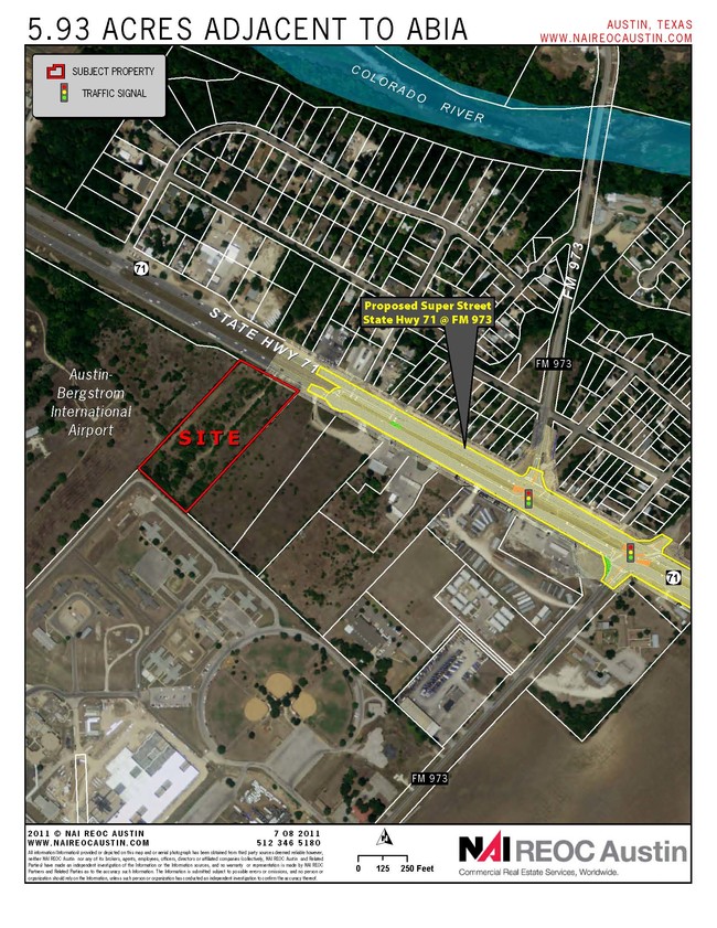

Property Detail
E State Hy 71
Austin-Round Rock-San Marcos, TX
ABS 24 DELVALLE S ACR 159.71
295802
TRAVIS
Farms
Texas
AE The base floodplain where base flood elevations are provided. AE Zones are now used on new format FIRMs instead of A1-A30 Zones.
159.71 AC
2025
Southeast
2025
Austin
002453
NEARBY LISTINGS FOR SALE OR LEASE
DEMOGRAPHICS near E State Hy 71
1 mile
3 mile
5 mile
2025 Total Population
876
15,975
45,967
2030 Population
1,007
17,134
49,042
Pop Growth 2025-2030
+ 14.95%
+ 7.26%
+ 6.69%
Average Age
37
35
35
2025 Total Households
290
4,578
14,090
HH Growth 2025-2030
+ 16.21%
+ 8.04%
+ 7.45%
Median Household Inc
$58,420
$90,739
$91,128
Avg Household Size
2.90
3.40
3.10
2025 Avg HH Vehicles
4.00
2.00
2.00
Median Home Value
$230,645
$310,466
$329,957
Median Year Built
2011
2010
2010
Nearby Places
Map Layers
Map Styles
 Street
 Aerial
Transit
 Traffic
 Biking
Places
Listings with unknown addresses are not visible on the map
- Restaurants
- Banks
- Shops
- Fitness
- Groceries
PUBLIC TRANSPORTATION
AIRPORT
Austin-Bergstrom International
Drive
Walk
Distance
Austin-Bergstrom International
18 min
7.4 mi
Freight Ports
Calhoun Port
Drive
Walk
Distance
Calhoun Port
178 min
150.3 mi
Nearby Properties
Address
Land Use
TOTAL SIZE
Lot Size
Zoning
Address
Land Use
TOTAL SIZE
Lot Size
Zoning
354,664 SF
16.80 AC
Address
Land Use
TOTAL SIZE
Lot Size
Zoning
206,608 SF
10.61 AC
Address
Land Use
TOTAL SIZE
Lot Size
Zoning
179,800 SF
442.94 AC
Address
Land Use
TOTAL SIZE
Lot Size
Zoning
247,500 SF
15.78 AC
Address
Land Use
TOTAL SIZE
Lot Size
Zoning
237,600 SF
10.10 AC
Address
Land Use
TOTAL SIZE
Lot Size
Zoning
7,366 SF
88.64 AC
Address
Land Use
TOTAL SIZE
Lot Size
Zoning
295,980 SF
47.98 AC
Address
Land Use
TOTAL SIZE
Lot Size
Zoning
4,843 SF
150.70 AC
Address
Land Use
TOTAL SIZE
Lot Size
Zoning
139,750 SF
50.37 AC
Address
Land Use
TOTAL SIZE
Lot Size
Zoning
215,912 SF
40.94 AC
Address
Land Use
TOTAL SIZE
Lot Size
Zoning
231,888 SF
11.86 AC
Address
Land Use
TOTAL SIZE
Lot Size
Zoning
4,098 SF
201.61 AC
Address
Land Use
TOTAL SIZE
Lot Size
Zoning
104,420 SF
23.55 AC
Address
Land Use
TOTAL SIZE
Lot Size
Zoning
80,562 SF
3.40 AC
Address
Land Use
TOTAL SIZE
Lot Size
Zoning
6,032 SF
207.65 AC
Address
Land Use
TOTAL SIZE
Lot Size
Zoning
2,359 SF
Address
Land Use
TOTAL SIZE
Lot Size
Zoning
149.67 AC
Address
Land Use
TOTAL SIZE
Lot Size
Zoning
41.29 AC
Address
Land Use
TOTAL SIZE
Lot Size
Zoning
126,304 SF
28.30 AC
Address
Land Use
TOTAL SIZE
Lot Size
Zoning
86.29 AC
Address
Land Use
TOTAL SIZE
Lot Size
Zoning
1,200 SF
24.07 AC
Address
Land Use
TOTAL SIZE
Lot Size
Zoning
550 SF
31.23 AC
Address
Land Use
TOTAL SIZE
Lot Size
Zoning
1 SF
50.13 AC
Address
Land Use
TOTAL SIZE
Lot Size
Zoning
58.96 AC
Address
Land Use
TOTAL SIZE
Lot Size
Zoning
52,992 SF
5.85 AC
Address
Land Use
TOTAL SIZE
Lot Size
Zoning
Address
Land Use
TOTAL SIZE
Lot Size
Zoning
54,624 SF
3.91 AC
Address
Land Use
TOTAL SIZE
Lot Size
Zoning
3,502 SF
24.69 AC
Address
Land Use
TOTAL SIZE
Lot Size
Zoning
16,400 SF
6.35 AC
Address
Land Use
TOTAL SIZE
Lot Size
Zoning
50,068 SF
5.71 AC
The World's #1 Commercial Real Estate Marketplace
Connect with us
© 2026 CoStar Group
The information above has been obtained from sources believed reliable. While we do not doubt its accuracy we have not verified it and make no guarantee, warranty or representation about it. It is your responsibility to independently confirm its accuracy and completeness. Any projections, opinions, assumptions, or estimates used are for example only and do not represent the current or future performance of the property. The value of this transaction to you depends on tax and other factors which should be evaluated by your tax, financial, and legal advisors. You and your advisors should conduct a careful, independent investigation of the property to determine to your satisfaction the suitability of the property for your needs.