Property Record
E State Hy 71, Del Valle, TX 78617


Save to a Folder
{{folder.Name}}
{{folder.ListingIds.length}} Properties
{{folder.ListingIds.length}} Property
Create a New Folder
Property Detail
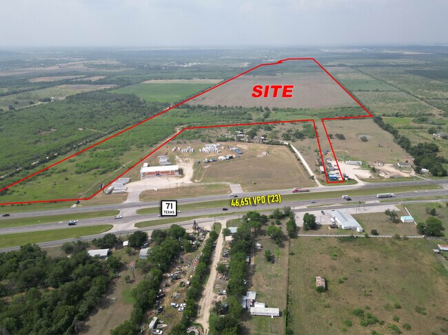
E State Hy 71
Austin-Round Rock-San Marcos, TX
ABS 18 NAVARRO J A ACR 233.7070 (1-D-1)
446069
TRAVIS
Recreationalacreage
Texas
A Areas with a 1% annual chance of flooding and a 26% chance of flooding over the life of a 30-year mortgage.
233.71 AC
2025
Southeast
2025
Austin
002453
NEARBY LISTINGS FOR SALE OR LEASE
DEMOGRAPHICS near E State Hy 71
1 mile
3 mile
5 mile
2025 Total Population
227
2,267
31,381
2030 Population
238
2,412
33,566
Pop Growth 2025-2030
+ 4.85%
+ 6.40%
+ 6.96%
Average Age
39
39
35
2025 Total Households
70
718
9,459
HH Growth 2025-2030
+ 5.71%
+ 7.24%
+ 7.68%
Median Household Inc
$73,845
$82,123
$91,067
Avg Household Size
3.00
3.00
3.20
2025 Avg HH Vehicles
2.00
2.00
2.00
Median Home Value
$76,666
$156,521
$314,010
Median Year Built
1983
1990
2008
Nearby Places
Map Layers
Map Styles
 Street
 Aerial
Layers
 Traffic
 Biking
Places
Listings with unknown addresses are not visible on the map
- Restaurants
- Banks
- Shops
- Fitness
- Groceries
PUBLIC TRANSPORTATION
AIRPORT
Austin-Bergstrom International
Drive
Walk
Distance
Austin-Bergstrom International
25 min
11.6 mi
Freight Ports
Calhoun Port
Drive
Walk
Distance
Calhoun Port
185 min
154.5 mi
SALE & LEASE HISTORY
LISTING DATE
SALE/LEASE

Jun 06, 2025
For Sale
Nearby Properties
Address
Land Use
TOTAL SIZE
Lot Size
Zoning
Address
Land Use
TOTAL SIZE
Lot Size
Zoning
1 SF
120 AC
Address
Land Use
TOTAL SIZE
Lot Size
Zoning
237,600 SF
10.10 AC
Address
Land Use
TOTAL SIZE
Lot Size
Zoning
215,912 SF
40.94 AC
Address
Land Use
TOTAL SIZE
Lot Size
Zoning
4,098 SF
201.61 AC
Address
Land Use
TOTAL SIZE
Lot Size
Zoning
6,032 SF
207.65 AC
Address
Land Use
TOTAL SIZE
Lot Size
Zoning
149.67 AC
Address
Land Use
TOTAL SIZE
Lot Size
Zoning
363,381 SF
15.26 AC
Address
Land Use
TOTAL SIZE
Lot Size
Zoning
550 SF
31.23 AC
Address
Land Use
TOTAL SIZE
Lot Size
Zoning
52,992 SF
5.85 AC
Address
Land Use
TOTAL SIZE
Lot Size
Zoning
16,400 SF
6.35 AC
Address
Land Use
TOTAL SIZE
Lot Size
Zoning
90,251 SF
12.48 AC
Address
Land Use
TOTAL SIZE
Lot Size
Zoning
4,137 SF
42.56 AC
Address
Land Use
TOTAL SIZE
Lot Size
Zoning
19,520 SF
5.91 AC
Address
Land Use
TOTAL SIZE
Lot Size
Zoning
238.94 AC
Address
Land Use
TOTAL SIZE
Lot Size
Zoning
136.60 AC
Address
Land Use
TOTAL SIZE
Lot Size
Zoning
7,653 SF
36.99 AC
Address
Land Use
TOTAL SIZE
Lot Size
Zoning
33,530 SF
Address
Land Use
TOTAL SIZE
Lot Size
Zoning
43.26 AC
Address
Land Use
TOTAL SIZE
Lot Size
Zoning
19,968 SF
0.58 AC
Address
Land Use
TOTAL SIZE
Lot Size
Zoning
48,254 SF
9.42 AC
Address
Land Use
TOTAL SIZE
Lot Size
Zoning
6,633 SF
18.82 AC
Address
Land Use
TOTAL SIZE
Lot Size
Zoning
139.67 AC
Address
Land Use
TOTAL SIZE
Lot Size
Zoning
113.55 AC
Address
Land Use
TOTAL SIZE
Lot Size
Zoning
54,640 SF
6.40 AC
Address
Land Use
TOTAL SIZE
Lot Size
Zoning
104.29 AC
Address
Land Use
TOTAL SIZE
Lot Size
Zoning
900 SF
425.40 AC
Address
Land Use
TOTAL SIZE
Lot Size
Zoning
7,500 SF
0.92 AC
Address
Land Use
TOTAL SIZE
Lot Size
Zoning
119.06 AC
Address
Land Use
TOTAL SIZE
Lot Size
Zoning
5,315 SF
5.87 AC
Address
Land Use
TOTAL SIZE
Lot Size
Zoning
10,232 SF
278.51 AC
The World's #1 Commercial Real Estate Marketplace
Connect with us
© 2026 CoStar Group
The information above has been obtained from sources believed reliable. While we do not doubt its accuracy we have not verified it and make no guarantee, warranty or representation about it. It is your responsibility to independently confirm its accuracy and completeness. Any projections, opinions, assumptions, or estimates used are for example only and do not represent the current or future performance of the property. The value of this transaction to you depends on tax and other factors which should be evaluated by your tax, financial, and legal advisors. You and your advisors should conduct a careful, independent investigation of the property to determine to your satisfaction the suitability of the property for your needs.