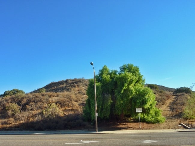
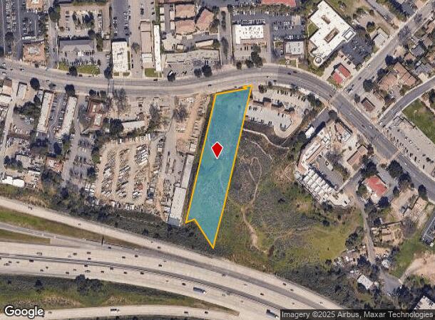
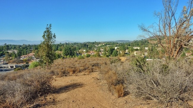
Property Record
1000 E Oaks Blvd, Thousand Oaks, CA 91362

NEARBY LISTINGS FOR SALE OR LEASE
-
-
-
-
No Photo
-
-
View all Thousand Oaks listings for sale on LoopNet.com
Property Detail
1000 E Oaks Blvd
Oxnard-Thousand Oaks-Ventura, CA
Thousand Oaks Tract
670-0-170-150
MAP 8 PG 73 BLK 25 PART OF LOT 18
Commercialacreage
Ventura
X
California
06111C0986E
2.22 AC
2024
Thousand Oaks/SE County
2025
Los Angeles
007202
DEMOGRAPHICS near 1000 E Oaks Blvd
1 Mile
3 Mile
5 Mile
2024 Total Population
10,083
66,529
135,823
2029 Population
9,953
65,741
133,765
Pop Growth 2024-2029
(1.29%)
(1.18%)
(1.52%)
Average Age
41
44
44
2024 Total Households
4,047
25,584
50,317
HH Growth 2024-2029
(1.33%)
(1.28%)
(1.61%)
Median Household Inc
$81,647
$112,705
$124,155
Avg Household Size
2.40
2.50
2.60
2024 Avg HH Vehicles
2.00
2.00
2.00
Median Home Value
$689,111
$853,453
$865,085
Median Year Built
1977
1975
1978
Nearby Places
Map Layers
Map Styles
 Street
 Aerial
- Restaurants
- Banks
- Shops
- Fitness
- Groceries
PUBLIC TRANSPORTATION
COMMUTER RAIL
Moorpark (Ventura County Line - Southern California Regional Rail Authority (Metrolink))
DRIVE
WALK
Distance
Moorpark (Ventura County Line - Southern California Regional Rail Authority (Metrolink))
14 min
9.8 mi
AIRPORT
Bob Hope
DRIVE
WALK
Distance
Bob Hope
45 min
33.7 mi
Freight Ports
The Port of Hueneme
DRIVE
WALK
Distance
The Port of Hueneme
34 min
23.4 mi
SALE & LEASE HISTORY
LISTING DATE
SALE/LEASE

Sep 24, 2016
For Sale
Nearby Properties
Address
Land Use
TOTAL SIZE
Lot Size
Zoning
Address
Land Use
TOTAL SIZE
Lot Size
Zoning
13.12 AC
PL
Address
Land Use
TOTAL SIZE
Lot Size
Zoning
38,851 SF
40.49 AC
M-1
Address
Land Use
TOTAL SIZE
Lot Size
Zoning
239,224 SF
11.65 AC
Address
Land Use
TOTAL SIZE
Lot Size
Zoning
253,686 SF
13.69 AC
RPD2
Address
Land Use
TOTAL SIZE
Lot Size
Zoning
233,391 SF
11.71 AC
RPD2
Address
Land Use
TOTAL SIZE
Lot Size
Zoning
Address
Land Use
TOTAL SIZE
Lot Size
Zoning
384,742 SF
19.93 AC
RPD2
Address
Land Use
TOTAL SIZE
Lot Size
Zoning
199,586 SF
8.95 AC
RPD25
Address
Land Use
TOTAL SIZE
Lot Size
Zoning
15,596 SF
3.17 AC
C2
Address
Land Use
TOTAL SIZE
Lot Size
Zoning
17,278 SF
15.46 AC
Address
Land Use
TOTAL SIZE
Lot Size
Zoning
182,756 SF
8.88 AC
RPD1
Address
Land Use
TOTAL SIZE
Lot Size
Zoning
162,078 SF
9.05 AC
R3
Address
Land Use
TOTAL SIZE
Lot Size
Zoning
10.63 AC
C4
Address
Land Use
TOTAL SIZE
Lot Size
Zoning
2,398 SF
11.59 AC
C2
Address
Land Use
TOTAL SIZE
Lot Size
Zoning
117,172 SF
14.47 AC
C1
Address
Land Use
TOTAL SIZE
Lot Size
Zoning
177,503 SF
5.36 AC
Address
Land Use
TOTAL SIZE
Lot Size
Zoning
26,654 SF
17.84 AC
C3
Address
Land Use
TOTAL SIZE
Lot Size
Zoning
127,196 SF
10.18 AC
MULT
Address
Land Use
TOTAL SIZE
Lot Size
Zoning
206,886 SF
12.11 AC
Address
Land Use
TOTAL SIZE
Lot Size
Zoning
6,606 SF
5.42 AC
M1
Address
Land Use
TOTAL SIZE
Lot Size
Zoning
90,194 SF
4.12 AC
Address
Land Use
TOTAL SIZE
Lot Size
Zoning
365,098 SF
18.18 AC
WVM1*
Address
Land Use
TOTAL SIZE
Lot Size
Zoning
73,421 SF
2.66 AC
C2
Address
Land Use
TOTAL SIZE
Lot Size
Zoning
42,203 SF
16.37 AC
CHEVRON TE
Address
Land Use
TOTAL SIZE
Lot Size
Zoning
94,268 SF
0.81 AC
Address
Land Use
TOTAL SIZE
Lot Size
Zoning
89,664 SF
5.03 AC
R-3
Address
Land Use
TOTAL SIZE
Lot Size
Zoning
123,248 SF
8.70 AC
RPD2
Address
Land Use
TOTAL SIZE
Lot Size
Zoning
73,565 SF
5.27 AC
MULT
Address
Land Use
TOTAL SIZE
Lot Size
Zoning
21,878 SF
8.22 AC
C4
Address
Land Use
TOTAL SIZE
Lot Size
Zoning
2.13 AC
M1
The World's #1 Commercial Real Estate Marketplace
Connect with us
© 2026 CoStar Group
The information above has been obtained from sources believed reliable. While we do not doubt its accuracy we have not verified it and make no guarantee, warranty or representation about it. It is your responsibility to independently confirm its accuracy and completeness. Any projections, opinions, assumptions, or estimates used are for example only and do not represent the current or future performance of the property. The value of this transaction to you depends on tax and other factors which should be evaluated by your tax, financial, and legal advisors. You and your advisors should conduct a careful, independent investigation of the property to determine to your satisfaction the suitability of the property for your needs.