Property Record
E Us Highway 64 Hwy, Lexington, NC 27292

Property Detail
E Us Highway 64 Hwy
05-029-0-000-0022-0-0-0
L22 BK2540-1115 US 64
Vacantlandnec
DAVIDSON
LI
North Carolina
B and X Area of moderate flood hazard, usually the area between the limits of the 100-year and 500-year floods.
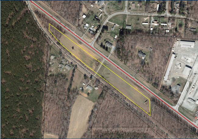
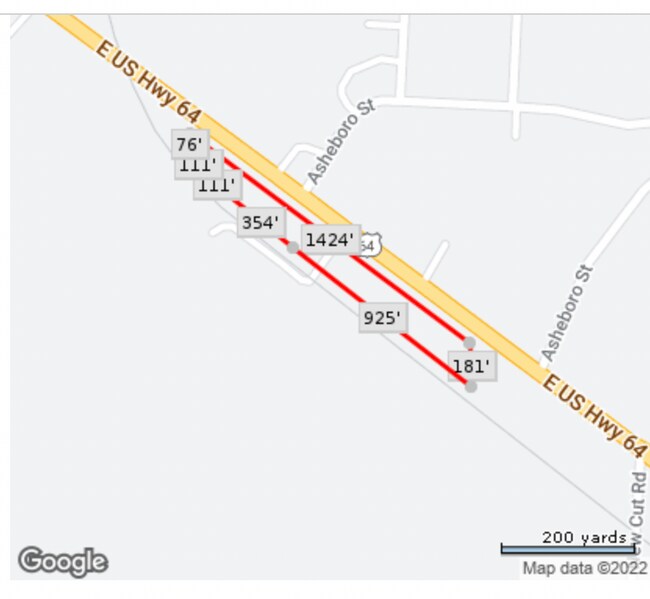
3.29 AC
2025
South Davidson County
2025
Greensboro/Winston-Salem
061805
Winston-Salem, NC
NEARBY LISTINGS FOR SALE OR LEASE
-
-
View all Lexington listings for sale on LoopNet.com
DEMOGRAPHICS near E Us Highway 64 Hwy
1 mile
3 mile
5 mile
2025 Total Population
3,334
25,415
41,035
2030 Population
3,562
26,940
43,356
Pop Growth 2025-2030
+ 6.84%
+ 6.00%
+ 5.66%
Average Age
38
40
41
2025 Total Households
1,275
10,204
16,621
HH Growth 2025-2030
+ 7.29%
+ 6.13%
+ 5.76%
Median Household Inc
$43,423
$45,292
$55,346
Avg Household Size
2.40
2.40
2.40
2025 Avg HH Vehicles
2.00
2.00
2.00
Median Home Value
$140,804
$180,317
$199,935
Median Year Built
1973
1975
1978
Nearby Places
Map Layers
Map Styles
 Street
 Aerial
Layers
 Traffic
 Biking
Places
Listings with unknown addresses are not visible on the map
- Restaurants
- Banks
- Shops
- Fitness
- Groceries
PUBLIC TRANSPORTATION
AIRPORT
Piedmont Triad International
Drive
Walk
Distance
Piedmont Triad International
49 min
36.2 mi
Freight Ports
Port of Wilmington
Drive
Walk
Distance
Port of Wilmington
245 min
205.2 mi
SALE & LEASE HISTORY
LISTING DATE
SALE/LEASE

Nov 08, 2022
For Sale
Nearby Properties
Address
Land Use
TOTAL SIZE
Lot Size
Zoning
Address
Land Use
TOTAL SIZE
Lot Size
Zoning
122,218 SF
106.02 AC
HI
Address
Land Use
TOTAL SIZE
Lot Size
Zoning
20,918 SF
42.08 AC
HI
Address
Land Use
TOTAL SIZE
Lot Size
Zoning
70,640 SF
29.08 AC
RA3
Address
Land Use
TOTAL SIZE
Lot Size
Zoning
84,523 SF
26.56 AC
RA1
Address
Land Use
TOTAL SIZE
Lot Size
Zoning
4,380 SF
21.17 AC
RA3
Address
Land Use
TOTAL SIZE
Lot Size
Zoning
55,585 SF
7.98 AC
HC
Address
Land Use
TOTAL SIZE
Lot Size
Zoning
5,200 SF
73.74 AC
LI
Address
Land Use
TOTAL SIZE
Lot Size
Zoning
800 SF
48.35 AC
HI
Address
Land Use
TOTAL SIZE
Lot Size
Zoning
149,240 SF
11.45 AC
HI
Address
Land Use
TOTAL SIZE
Lot Size
Zoning
19,061 SF
20.83 AC
OI
Address
Land Use
TOTAL SIZE
Lot Size
Zoning
7,650 SF
26.91 AC
OI
Address
Land Use
TOTAL SIZE
Lot Size
Zoning
547 SF
123.66 AC
HI
Address
Land Use
TOTAL SIZE
Lot Size
Zoning
4,800 SF
6.54 AC
HC
Address
Land Use
TOTAL SIZE
Lot Size
Zoning
65,252 SF
147.85 AC
HI
Address
Land Use
TOTAL SIZE
Lot Size
Zoning
15,527 SF
3.03 AC
HC
Address
Land Use
TOTAL SIZE
Lot Size
Zoning
9,337 SF
6.98 AC
RA3
Address
Land Use
TOTAL SIZE
Lot Size
Zoning
6,678 SF
38.02 AC
HC
Address
Land Use
TOTAL SIZE
Lot Size
Zoning
32,525 SF
1.75 AC
HI
Address
Land Use
TOTAL SIZE
Lot Size
Zoning
111.13 AC
RA3
Address
Land Use
TOTAL SIZE
Lot Size
Zoning
19,492 SF
7.93 AC
RA3
Address
Land Use
TOTAL SIZE
Lot Size
Zoning
5,596 SF
28.92 AC
LI
Address
Land Use
TOTAL SIZE
Lot Size
Zoning
15,219 SF
15.10 AC
HI
Address
Land Use
TOTAL SIZE
Lot Size
Zoning
9,800 SF
3.38 AC
HC
Address
Land Use
TOTAL SIZE
Lot Size
Zoning
0.85 AC
RA3
Address
Land Use
TOTAL SIZE
Lot Size
Zoning
10,000 SF
11.02 AC
LI
Address
Land Use
TOTAL SIZE
Lot Size
Zoning
9,756 SF
5 AC
RA3
Address
Land Use
TOTAL SIZE
Lot Size
Zoning
9,180 SF
1.35 AC
HC
Address
Land Use
TOTAL SIZE
Lot Size
Zoning
5,092 SF
4.89 AC
RC
Address
Land Use
TOTAL SIZE
Lot Size
Zoning
7,018 SF
5.34 AC
HC
Address
Land Use
TOTAL SIZE
Lot Size
Zoning
14,880 SF
9.76 AC
LI
The World's #1 Commercial Real Estate Marketplace
Connect with us
© 2026 CoStar Group
The information above has been obtained from sources believed reliable. While we do not doubt its accuracy we have not verified it and make no guarantee, warranty or representation about it. It is your responsibility to independently confirm its accuracy and completeness. Any projections, opinions, assumptions, or estimates used are for example only and do not represent the current or future performance of the property. The value of this transaction to you depends on tax and other factors which should be evaluated by your tax, financial, and legal advisors. You and your advisors should conduct a careful, independent investigation of the property to determine to your satisfaction the suitability of the property for your needs.