Property Record
Via Roma, Colton, CA 92324


NEARBY LISTINGS FOR SALE OR LEASE
-
-
-
-
-
-
-
-
NWQ of E. Hospitality Lane & Harriman Place
San Bernardino, CA 92408
Rent Upon Request
0.89 AC Lots
Land
-
-
-
-
-
-
-
View all Colton listings for sale on LoopNet.com
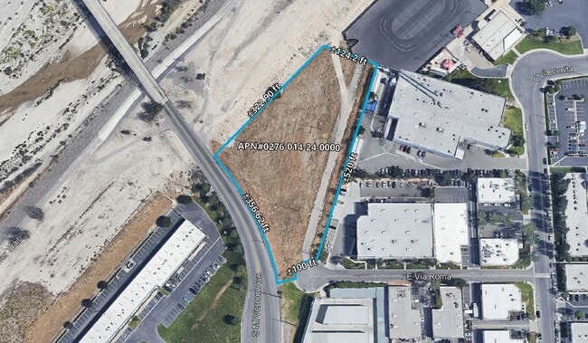
Property Detail
Via Roma
Riverside-San Bernardino-Ontario, CA
Parcel Map 10057
0276-014-24
PARCEL MAP 10057 PARCEL 5
Vacantlandnec
San Bernardino
X
California
06071C8691J
2.16 AC
2024
San Bernardino
2025
Inland Empire (California)
012500
DEMOGRAPHICS near Via Roma
1 Mile
3 Mile
5 Mile
2024 Total Population
13,261
83,985
252,849
2029 Population
13,527
85,468
258,060
Pop Growth 2024-2029
+ 2.01%
+ 1.77%
+ 2.06%
Average Age
33
36
35
2024 Total Households
4,492
26,513
74,157
HH Growth 2024-2029
+ 2.09%
+ 1.88%
+ 2.15%
Median Household Inc
$60,875
$64,068
$62,474
Avg Household Size
2.90
3.10
3.30
2024 Avg HH Vehicles
2.00
2.00
2.00
Median Home Value
$347,962
$381,255
$371,018
Median Year Built
1983
1976
1975
Nearby Places
Map Layers
Map Styles
 Street
 Aerial
- Restaurants
- Banks
- Shops
- Fitness
- Groceries
PUBLIC TRANSPORTATION
COMMUTER RAIL
San Bernardino (Inland Empire-Orange County Line - Southern California Regional Rail Authority (Metrolink), San Bernardino Line - Southern California Regional Rail Authority (Metrolink))
DRIVE
WALK
Distance
San Bernardino (Inland Empire-Orange County Line - Southern California Regional Rail Authority (Metrolink), San Bernardino Line - Southern California Regional Rail Authority (Metrolink))
10 min
4.0 mi
DRIVE
WALK
Distance
11 min
4.5 mi
AIRPORT
Ontario International
DRIVE
WALK
Distance
Ontario International
27 min
19.2 mi
John Wayne/Orange County
DRIVE
WALK
Distance
John Wayne/Orange County
60 min
49.1 mi
SALE & LEASE HISTORY
LISTING DATE
SALE/LEASE

Oct 17, 2022
For Sale
Mar 22, 2021
For Sale
Nearby Properties
Address
Land Use
TOTAL SIZE
Lot Size
Zoning
Address
Land Use
TOTAL SIZE
Lot Size
Zoning
1,831,174 SF
20.38 AC
Address
Land Use
TOTAL SIZE
Lot Size
Zoning
457,253 SF
20.14 AC
Address
Land Use
TOTAL SIZE
Lot Size
Zoning
308,030 SF
16.20 AC
Address
Land Use
TOTAL SIZE
Lot Size
Zoning
1,032,072 SF
61.74 AC
Address
Land Use
TOTAL SIZE
Lot Size
Zoning
411,707 SF
19.34 AC
Address
Land Use
TOTAL SIZE
Lot Size
Zoning
330,420 SF
15.31 AC
Address
Land Use
TOTAL SIZE
Lot Size
Zoning
340,120 SF
36.36 AC
Address
Land Use
TOTAL SIZE
Lot Size
Zoning
1,081,199 SF
49.77 AC
Address
Land Use
TOTAL SIZE
Lot Size
Zoning
300,188 SF
11.98 AC
Address
Land Use
TOTAL SIZE
Lot Size
Zoning
182,624 SF
16.07 AC
Address
Land Use
TOTAL SIZE
Lot Size
Zoning
245,476 SF
15.61 AC
Address
Land Use
TOTAL SIZE
Lot Size
Zoning
391,468 SF
16.73 AC
Address
Land Use
TOTAL SIZE
Lot Size
Zoning
210,418 SF
12.09 AC
Address
Land Use
TOTAL SIZE
Lot Size
Zoning
225,324 SF
11.03 AC
Address
Land Use
TOTAL SIZE
Lot Size
Zoning
851,880 SF
42.20 AC
Address
Land Use
TOTAL SIZE
Lot Size
Zoning
178,400 SF
8.23 AC
Address
Land Use
TOTAL SIZE
Lot Size
Zoning
549,796 SF
13.61 AC
Address
Land Use
TOTAL SIZE
Lot Size
Zoning
182,446 SF
9.01 AC
Address
Land Use
TOTAL SIZE
Lot Size
Zoning
14,000 SF
Address
Land Use
TOTAL SIZE
Lot Size
Zoning
147,744 SF
14.58 AC
Address
Land Use
TOTAL SIZE
Lot Size
Zoning
341,904 SF
1.84 AC
Address
Land Use
TOTAL SIZE
Lot Size
Zoning
151,859 SF
7.23 AC
Address
Land Use
TOTAL SIZE
Lot Size
Zoning
592,710 SF
28.89 AC
Address
Land Use
TOTAL SIZE
Lot Size
Zoning
318,940 SF
14.26 AC
Address
Land Use
TOTAL SIZE
Lot Size
Zoning
154,639 SF
6.87 AC
Address
Land Use
TOTAL SIZE
Lot Size
Zoning
16,000 SF
11.17 AC
Address
Land Use
TOTAL SIZE
Lot Size
Zoning
218,823 SF
6.70 AC
Address
Land Use
TOTAL SIZE
Lot Size
Zoning
153,093 SF
2.69 AC
Address
Land Use
TOTAL SIZE
Lot Size
Zoning
122,738 SF
10.77 AC
Address
Land Use
TOTAL SIZE
Lot Size
Zoning
345,237 SF
14.52 AC
The World's #1 Commercial Real Estate Marketplace
Connect with us
© 2025 CoStar Group
The information above has been obtained from sources believed reliable. While we do not doubt its accuracy we have not verified it and make no guarantee, warranty or representation about it. It is your responsibility to independently confirm its accuracy and completeness. Any projections, opinions, assumptions, or estimates used are for example only and do not represent the current or future performance of the property. The value of this transaction to you depends on tax and other factors which should be evaluated by your tax, financial, and legal advisors. You and your advisors should conduct a careful, independent investigation of the property to determine to your satisfaction the suitability of the property for your needs.