Property Record
Dolores Dr, Sparks, NV 89436


Save to a Folder
{{folder.Name}}
{{folder.ListingIds.length}} Properties
{{folder.ListingIds.length}} Property
Create a New Folder
Property Detail
Dolores Dr
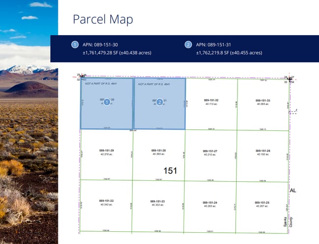
089-151-30
NW4 NW4 SEC 33 TWP 21 RGE 20
Residentialacreage
WASHOE
NUD
Nevada
B and X Area of moderate flood hazard, usually the area between the limits of the 100-year and 500-year floods.
40.44 AC
2025
N Outlying Washoe County
2026
Reno/Sparks
003512
Reno, NV
NEARBY LISTINGS FOR SALE OR LEASE
DEMOGRAPHICS near Dolores Dr
1 mile
3 mile
5 mile
2025 Total Population
650
22,630
78,457
2030 Population
665
23,812
81,429
Pop Growth 2025-2030
+ 2.31%
+ 5.22%
+ 3.79%
Average Age
44
41
41
2025 Total Households
247
7,943
27,320
HH Growth 2025-2030
+ 2.43%
+ 5.21%
+ 3.86%
Median Household Inc
$105,067
$113,309
$105,341
Avg Household Size
2.60
2.80
2.80
2025 Avg HH Vehicles
2.00
3.00
2.00
Median Home Value
$625,912
$602,598
$569,690
Median Year Built
1998
2002
2002
Nearby Places
Map Layers
Map Styles
 Street
 Aerial
Layers
 Traffic
 Biking
Places
Listings with unknown addresses are not visible on the map
- Restaurants
- Banks
- Shops
- Fitness
- Groceries
PUBLIC TRANSPORTATION
AIRPORT
Reno/Tahoe International
Drive
Walk
Distance
Reno/Tahoe International
40 min
17.4 mi
Freight Ports
Port of Stockton
Drive
Walk
Distance
Port of Stockton
226 min
191.8 mi
Nearby Properties
Address
Land Use
TOTAL SIZE
Lot Size
Zoning
Address
Land Use
TOTAL SIZE
Lot Size
Zoning
289,637 SF
53.48 AC
PSP
Address
Land Use
TOTAL SIZE
Lot Size
Zoning
238,764 SF
7 AC
NC
Address
Land Use
TOTAL SIZE
Lot Size
Zoning
231,353 SF
11.52 AC
NUD
Address
Land Use
TOTAL SIZE
Lot Size
Zoning
188,281 SF
641.92 AC
OS 88% / G
Address
Land Use
TOTAL SIZE
Lot Size
Zoning
209,527 SF
5.28 AC
NC
Address
Land Use
TOTAL SIZE
Lot Size
Zoning
160,562 SF
17.10 AC
I
Address
Land Use
TOTAL SIZE
Lot Size
Zoning
464,360 SF
36.05 AC
I
Address
Land Use
TOTAL SIZE
Lot Size
Zoning
181,857 SF
8.19 AC
NUD
Address
Land Use
TOTAL SIZE
Lot Size
Zoning
408,965 SF
20.44 AC
I
Address
Land Use
TOTAL SIZE
Lot Size
Zoning
412,614 SF
25.93 AC
I
Address
Land Use
TOTAL SIZE
Lot Size
Zoning
411,100 SF
19.44 AC
I
Address
Land Use
TOTAL SIZE
Lot Size
Zoning
197,364 SF
11.34 AC
NUD
Address
Land Use
TOTAL SIZE
Lot Size
Zoning
186,572 SF
12.17 AC
NUD
Address
Land Use
TOTAL SIZE
Lot Size
Zoning
408,660 SF
20.15 AC
I
Address
Land Use
TOTAL SIZE
Lot Size
Zoning
185,000 SF
10 AC
I
Address
Land Use
TOTAL SIZE
Lot Size
Zoning
146,900 SF
10 AC
I
Address
Land Use
TOTAL SIZE
Lot Size
Zoning
55,704 SF
14.03 AC
MDS 1% / O
Address
Land Use
TOTAL SIZE
Lot Size
Zoning
122,223 SF
20 AC
PSP
Address
Land Use
TOTAL SIZE
Lot Size
Zoning
152,640 SF
24.48 AC
I
Address
Land Use
TOTAL SIZE
Lot Size
Zoning
106,387 SF
10.45 AC
I
Address
Land Use
TOTAL SIZE
Lot Size
Zoning
144,000 SF
9.90 AC
I
Address
Land Use
TOTAL SIZE
Lot Size
Zoning
81,122 SF
8.44 AC
NUD
Address
Land Use
TOTAL SIZE
Lot Size
Zoning
121,680 SF
8.82 AC
I
Address
Land Use
TOTAL SIZE
Lot Size
Zoning
35.59 AC
NUD
Address
Land Use
TOTAL SIZE
Lot Size
Zoning
40.56 AC
NUD
Address
Land Use
TOTAL SIZE
Lot Size
Zoning
61,048 SF
13.10 AC
PSP
Address
Land Use
TOTAL SIZE
Lot Size
Zoning
27.02 AC
NUD
Address
Land Use
TOTAL SIZE
Lot Size
Zoning
102,137 SF
8.46 AC
NC
Address
Land Use
TOTAL SIZE
Lot Size
Zoning
13,372.63 AC
OS 45% / G
Address
Land Use
TOTAL SIZE
Lot Size
Zoning
34.89 AC
PD
The World's #1 Commercial Real Estate Marketplace
Connect with us
© 2026 CoStar Group
The information above has been obtained from sources believed reliable. While we do not doubt its accuracy we have not verified it and make no guarantee, warranty or representation about it. It is your responsibility to independently confirm its accuracy and completeness. Any projections, opinions, assumptions, or estimates used are for example only and do not represent the current or future performance of the property. The value of this transaction to you depends on tax and other factors which should be evaluated by your tax, financial, and legal advisors. You and your advisors should conduct a careful, independent investigation of the property to determine to your satisfaction the suitability of the property for your needs.