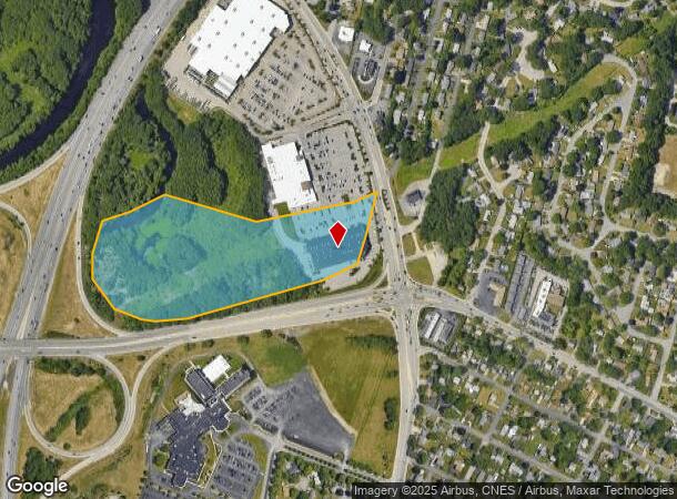
Property Record
East Ave, Warwick, RI 02886
NEARBY LISTINGS FOR SALE OR LEASE
Property Detail
East Ave
WARW M:271 B:0198 L:0000
Kent
Governmentalpublicusegeneral
Rhode Island
X
8.84 AC
44003C0127H
Warwick
0
Providence
2025
Providence-Warwick, RI-MA
022100
DEMOGRAPHICS near East Ave
1 Mile
3 Mile
5 Mile
2024 Total Population
7,207
60,669
189,876
2029 Population
7,326
61,303
191,225
Pop Growth 2024-2029
+ 1.65%
+ 1.05%
+ 0.71%
Average Age
47
44
43
2024 Total Households
3,529
25,745
80,256
HH Growth 2024-2029
+ 1.76%
+ 1.18%
+ 0.74%
Median Household Inc
$48,918
$73,233
$74,119
Avg Household Size
2.00
2.20
2.30
2024 Avg HH Vehicles
1.00
2.00
2.00
Median Home Value
$327,444
$311,965
$305,125
Median Year Built
1967
1965
1961
Nearby Places
Map Layers
Map Styles
 Street
 Aerial
- Restaurants
- Banks
- Shops
- Fitness
- Groceries
PUBLIC TRANSPORTATION
AIRPORT
Rhode Island Tf Green International
DRIVE
WALK
Distance
Rhode Island Tf Green International
14 min
5.6 mi
Freight Ports
Port of Davisville, RI
DRIVE
WALK
Distance
Port of Davisville, RI
1 min
7.7 mi
SALE & LEASE HISTORY
LISTING DATE
SALE/LEASE

Sep 25, 2016
For Lease
Jun 01, 2018
For Lease
Nearby Properties
Address
Land Use
TOTAL SIZE
Lot Size
Zoning
Address
Land Use
TOTAL SIZE
Lot Size
Zoning
39.98 AC
S1
Address
Land Use
TOTAL SIZE
Lot Size
Zoning
45,000 SF
22.22 AC
M2
Address
Land Use
TOTAL SIZE
Lot Size
Zoning
24,276 SF
0.01 AC
A15
Address
Land Use
TOTAL SIZE
Lot Size
Zoning
6,640 SF
0.01 AC
A10
Address
Land Use
TOTAL SIZE
Lot Size
Zoning
13.40 AC
C3
Address
Land Use
TOTAL SIZE
Lot Size
Zoning
36.43 AC
S1
Address
Land Use
TOTAL SIZE
Lot Size
Zoning
33.13 AC
S1
Address
Land Use
TOTAL SIZE
Lot Size
Zoning
6,720 SF
0.01 AC
GB
Address
Land Use
TOTAL SIZE
Lot Size
Zoning
83,747 SF
20.32 AC
GB
Address
Land Use
TOTAL SIZE
Lot Size
Zoning
9.38 AC
S1
Address
Land Use
TOTAL SIZE
Lot Size
Zoning
171,576 SF
0.70 AC
O
Address
Land Use
TOTAL SIZE
Lot Size
Zoning
4,212 SF
32.62 AC
S1
Address
Land Use
TOTAL SIZE
Lot Size
Zoning
228,067 SF
30.74 AC
A7
Address
Land Use
TOTAL SIZE
Lot Size
Zoning
485,238 SF
2.05 AC
GB
Address
Land Use
TOTAL SIZE
Lot Size
Zoning
6,702 SF
49.97 AC
GI
Address
Land Use
TOTAL SIZE
Lot Size
Zoning
11.48 AC
R-10
Address
Land Use
TOTAL SIZE
Lot Size
Zoning
411,032 SF
31.40 AC
GB
Address
Land Use
TOTAL SIZE
Lot Size
Zoning
517,743 SF
3.55 AC
GI
Address
Land Use
TOTAL SIZE
Lot Size
Zoning
102,425 SF
11.66 AC
S1
Address
Land Use
TOTAL SIZE
Lot Size
Zoning
491,496 SF
46.72 AC
LI
Address
Land Use
TOTAL SIZE
Lot Size
Zoning
10.78 AC
MPD
Address
Land Use
TOTAL SIZE
Lot Size
Zoning
57,068 SF
3.73 AC
Address
Land Use
TOTAL SIZE
Lot Size
Zoning
25 AC
CI
Address
Land Use
TOTAL SIZE
Lot Size
Zoning
11.63 AC
R-10
Address
Land Use
TOTAL SIZE
Lot Size
Zoning
100,638 SF
6.80 AC
GB
Address
Land Use
TOTAL SIZE
Lot Size
Zoning
139,256 SF
29.40 AC
GB
Address
Land Use
TOTAL SIZE
Lot Size
Zoning
243,057 SF
9.59 AC
GB
Address
Land Use
TOTAL SIZE
Lot Size
Zoning
116,940 SF
23.17 AC
Address
Land Use
TOTAL SIZE
Lot Size
Zoning
138,213 SF
1.61 AC
MPD
Address
Land Use
TOTAL SIZE
Lot Size
Zoning
240,425 SF
104.76 AC
R-10
The World's #1 Commercial Real Estate Marketplace
Connect with us
© 2026 CoStar Group
The information above has been obtained from sources believed reliable. While we do not doubt its accuracy we have not verified it and make no guarantee, warranty or representation about it. It is your responsibility to independently confirm its accuracy and completeness. Any projections, opinions, assumptions, or estimates used are for example only and do not represent the current or future performance of the property. The value of this transaction to you depends on tax and other factors which should be evaluated by your tax, financial, and legal advisors. You and your advisors should conduct a careful, independent investigation of the property to determine to your satisfaction the suitability of the property for your needs.