Property Record
Eastern Ave, , MD


Property Detail
Eastern Ave
Baltimore-Columbia-Towson, MD
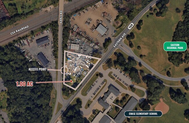
.124 AC NS EASTERN A
15-1502574053
BALTIMORE
Taxexempt
Maryland
B and X Area of moderate flood hazard, usually the area between the limits of the 100-year and 500-year floods.
0.12 AC
0
Baltimore County East
2025
Baltimore
451802
NEARBY LISTINGS FOR SALE OR LEASE
DEMOGRAPHICS near Eastern Ave
1 mile
3 mile
5 mile
2025 Total Population
6,170
39,965
115,578
2030 Population
6,189
40,257
116,454
Pop Growth 2025-2030
+ 0.31%
+ 0.73%
+ 0.76%
Average Age
41
39
40
2025 Total Households
2,624
15,350
44,982
HH Growth 2025-2030
+ 0.30%
+ 0.83%
+ 0.78%
Median Household Inc
$59,110
$85,052
$81,045
Avg Household Size
2.30
2.60
2.50
2025 Avg HH Vehicles
2.00
2.00
2.00
Median Home Value
$193,022
$322,243
$325,105
Median Year Built
1988
1984
1979
Nearby Places
Map Layers
Map Styles
 Street
 Aerial
Layers
 Traffic
 Biking
Places
Listings with unknown addresses are not visible on the map
- Restaurants
- Banks
- Shops
- Fitness
- Groceries
PUBLIC TRANSPORTATION
COMMUTER RAIL
Martin Airport Marc Nb (PENN - WASHINGTON - Maryland Transit Administration)
Drive
Walk
Distance
Martin Airport Marc Nb (PENN - WASHINGTON - Maryland Transit Administration)
4 min
1.8 mi
AIRPORT
Baltimore/Washington International Thurgood Marshall
Drive
Walk
Distance
Baltimore/Washington International Thurgood Marshall
41 min
25.3 mi
Freight Ports
Port of Baltimore
Drive
Walk
Distance
Port of Baltimore
27 min
15.7 mi
SALE & LEASE HISTORY
LISTING DATE
SALE/LEASE

May 13, 2025
For Lease
Nearby Properties
Address
Land Use
TOTAL SIZE
Lot Size
Zoning
Address
Land Use
TOTAL SIZE
Lot Size
Zoning
159,728 SF
0.02 AC
MH
Address
Land Use
TOTAL SIZE
Lot Size
Zoning
504,086 SF
7.48 AC
MH
Address
Land Use
TOTAL SIZE
Lot Size
Zoning
553,984 SF
7.42 AC
Address
Land Use
TOTAL SIZE
Lot Size
Zoning
83.12 AC
ML
Address
Land Use
TOTAL SIZE
Lot Size
Zoning
1,062,672 SF
70.27 AC
MHIM
Address
Land Use
TOTAL SIZE
Lot Size
Zoning
15.40 AC
DR16
Address
Land Use
TOTAL SIZE
Lot Size
Zoning
423,200 SF
22.60 AC
MH-1M
Address
Land Use
TOTAL SIZE
Lot Size
Zoning
14.19 AC
DR16
Address
Land Use
TOTAL SIZE
Lot Size
Zoning
14.28 AC
DR16
Address
Land Use
TOTAL SIZE
Lot Size
Zoning
21.83 AC
DR16
Address
Land Use
TOTAL SIZE
Lot Size
Zoning
440,340 SF
128.19 AC
Address
Land Use
TOTAL SIZE
Lot Size
Zoning
20.13 AC
DR16
Address
Land Use
TOTAL SIZE
Lot Size
Zoning
12.47 AC
DR16
Address
Land Use
TOTAL SIZE
Lot Size
Zoning
11.69 AC
DR16
Address
Land Use
TOTAL SIZE
Lot Size
Zoning
18 AC
DR16
Address
Land Use
TOTAL SIZE
Lot Size
Zoning
89,522 SF
4.03 AC
Address
Land Use
TOTAL SIZE
Lot Size
Zoning
128,400 SF
12.68 AC
Address
Land Use
TOTAL SIZE
Lot Size
Zoning
1,914,359 SF
24.44 AC
MHIM
Address
Land Use
TOTAL SIZE
Lot Size
Zoning
300,000 SF
85.04 AC
MH
Address
Land Use
TOTAL SIZE
Lot Size
Zoning
77,574 SF
3.23 AC
Address
Land Use
TOTAL SIZE
Lot Size
Zoning
3,844 SF
35.84 AC
Address
Land Use
TOTAL SIZE
Lot Size
Zoning
21.53 AC
DR16
Address
Land Use
TOTAL SIZE
Lot Size
Zoning
136,978 SF
12.06 AC
MH-IM
Address
Land Use
TOTAL SIZE
Lot Size
Zoning
168,640 SF
19.02 AC
BRCS1
Address
Land Use
TOTAL SIZE
Lot Size
Zoning
124,751 SF
9.24 AC
BM
Address
Land Use
TOTAL SIZE
Lot Size
Zoning
103,432 SF
5.53 AC
Address
Land Use
TOTAL SIZE
Lot Size
Zoning
10.37 AC
DR16
Address
Land Use
TOTAL SIZE
Lot Size
Zoning
50,400 SF
7.13 AC
MH
Address
Land Use
TOTAL SIZE
Lot Size
Zoning
72,120 SF
14.17 AC
DR5.5
Address
Land Use
TOTAL SIZE
Lot Size
Zoning
59,400 SF
4.98 AC
MH
The World's #1 Commercial Real Estate Marketplace
Connect with us
© 2026 CoStar Group
The information above has been obtained from sources believed reliable. While we do not doubt its accuracy we have not verified it and make no guarantee, warranty or representation about it. It is your responsibility to independently confirm its accuracy and completeness. Any projections, opinions, assumptions, or estimates used are for example only and do not represent the current or future performance of the property. The value of this transaction to you depends on tax and other factors which should be evaluated by your tax, financial, and legal advisors. You and your advisors should conduct a careful, independent investigation of the property to determine to your satisfaction the suitability of the property for your needs.