Property Record
Eberhardt Rd, Temple, TX 76504

Property Detail
Eberhardt Rd
17534
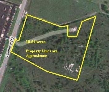
A0596BC A G MOORE, OB 1141, ACRES 9.05
Agriculturalland
BELL
A
Texas
B and X Area of moderate flood hazard, usually the area between the limits of the 100-year and 500-year floods.
9.05 AC
0
Temple
2025
Killeen/Temple/Fort Hood
021202
Killeen-Temple, TX
NEARBY LISTINGS FOR SALE OR LEASE
DEMOGRAPHICS near Eberhardt Rd
1 mile
3 mile
5 mile
2024 Total Population
3,806
39,082
81,637
2029 Population
4,089
41,627
87,235
Pop Growth 2024-2029
+ 7.44%
+ 6.51%
+ 6.86%
Average Age
36
38
38
2024 Total Households
1,504
16,349
32,934
HH Growth 2024-2029
+ 7.58%
+ 6.51%
+ 6.90%
Median Household Inc
$61,830
$56,709
$65,509
Avg Household Size
2.40
2.30
2.40
2024 Avg HH Vehicles
2.00
2.00
2.00
Median Home Value
$187,670
$190,265
$244,043
Median Year Built
1993
1979
1988
Nearby Places
Map Layers
Map Styles
 Street
 Aerial
Transit
 Traffic
 Biking
Places
Listings with unknown addresses are not visible on the map
- Restaurants
- Banks
- Shops
- Fitness
- Groceries
PUBLIC TRANSPORTATION
COMMUTER RAIL
Temple (Texas Eagle - Amtrak)
Drive
Walk
Distance
Temple (Texas Eagle - Amtrak)
5 min
2.5 mi
AIRPORT
Killeen Municipal
Drive
Walk
Distance
Killeen Municipal
29 min
23.5 mi
Robert Gray AAF
Drive
Walk
Distance
Robert Gray AAF
48 min
37.4 mi
Freight Ports
Port of Houston
Drive
Walk
Distance
Port of Houston
232 min
177.1 mi
Nearby Properties
Address
Land Use
TOTAL SIZE
Lot Size
Zoning
Address
Land Use
TOTAL SIZE
Lot Size
Zoning
1,656,661 SF
194.39 AC
Address
Land Use
TOTAL SIZE
Lot Size
Zoning
274,710 SF
38.05 AC
C
Address
Land Use
TOTAL SIZE
Lot Size
Zoning
86,326 SF
8.70 AC
MF1
Address
Land Use
TOTAL SIZE
Lot Size
Zoning
77,450 SF
16.51 AC
Address
Land Use
TOTAL SIZE
Lot Size
Zoning
Address
Land Use
TOTAL SIZE
Lot Size
Zoning
180,360 SF
9.66 AC
Address
Land Use
TOTAL SIZE
Lot Size
Zoning
208,941 SF
9.23 AC
Address
Land Use
TOTAL SIZE
Lot Size
Zoning
Address
Land Use
TOTAL SIZE
Lot Size
Zoning
71,378 SF
13.75 AC
Address
Land Use
TOTAL SIZE
Lot Size
Zoning
71,378 SF
14.37 AC
A
Address
Land Use
TOTAL SIZE
Lot Size
Zoning
214,028 SF
14.37 AC
Address
Land Use
TOTAL SIZE
Lot Size
Zoning
Address
Land Use
TOTAL SIZE
Lot Size
Zoning
188,072 SF
9.51 AC
C
Address
Land Use
TOTAL SIZE
Lot Size
Zoning
Address
Land Use
TOTAL SIZE
Lot Size
Zoning
265,000 SF
15.41 AC
Address
Land Use
TOTAL SIZE
Lot Size
Zoning
168,754 SF
10.36 AC
LI
Address
Land Use
TOTAL SIZE
Lot Size
Zoning
612,900 SF
38.68 AC
Address
Land Use
TOTAL SIZE
Lot Size
Zoning
41,630 SF
11.85 AC
Address
Land Use
TOTAL SIZE
Lot Size
Zoning
195,291 SF
36.30 AC
Address
Land Use
TOTAL SIZE
Lot Size
Zoning
153,043 SF
12.61 AC
Address
Land Use
TOTAL SIZE
Lot Size
Zoning
85,860 SF
4.26 AC
Address
Land Use
TOTAL SIZE
Lot Size
Zoning
161,036 SF
52.18 AC
PD
Address
Land Use
TOTAL SIZE
Lot Size
Zoning
71,931 SF
8.64 AC
Address
Land Use
TOTAL SIZE
Lot Size
Zoning
261,265 SF
17.50 AC
C
Address
Land Use
TOTAL SIZE
Lot Size
Zoning
1,088 SF
Address
Land Use
TOTAL SIZE
Lot Size
Zoning
159,250 SF
0.85 AC
CA
Address
Land Use
TOTAL SIZE
Lot Size
Zoning
81,608 SF
11.15 AC
2F
Address
Land Use
TOTAL SIZE
Lot Size
Zoning
206,897 SF
12.51 AC
COMB
Address
Land Use
TOTAL SIZE
Lot Size
Zoning
155,262 SF
10 AC
MF2
Address
Land Use
TOTAL SIZE
Lot Size
Zoning
176,542 SF
11.50 AC
COMB
The World's #1 Commercial Real Estate Marketplace
Connect with us
© 2026 CoStar Group
The information above has been obtained from sources believed reliable. While we do not doubt its accuracy we have not verified it and make no guarantee, warranty or representation about it. It is your responsibility to independently confirm its accuracy and completeness. Any projections, opinions, assumptions, or estimates used are for example only and do not represent the current or future performance of the property. The value of this transaction to you depends on tax and other factors which should be evaluated by your tax, financial, and legal advisors. You and your advisors should conduct a careful, independent investigation of the property to determine to your satisfaction the suitability of the property for your needs.