Property Record
El Centro Rd, Sacramento, CA 95835

Property Detail
El Centro Rd
Sacramento-Roseville-Folsom, CA
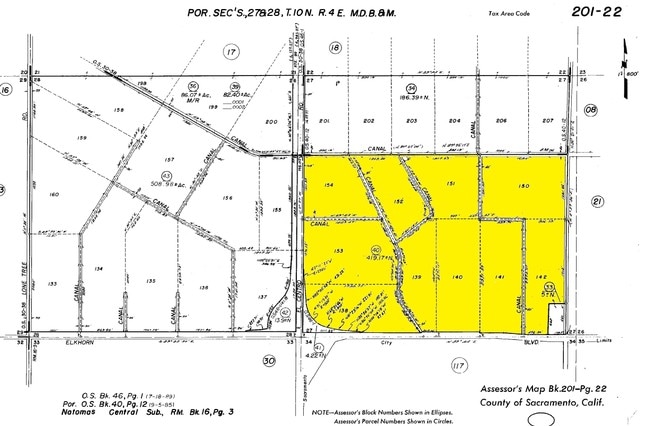
LOTS 138 THRU 142, LOTS 150 THRU 154 NATOMAS CENTRAL SUB EXCS 660 FT OF E 330 FT SD LOT 142 ALSO EXC POR LOTS 138, 153,& 154
201-0220-040
SACRAMENTO
Farms
California
AG-80
139
A99 Areas with a 1% annual chance of flooding that will be protected by a Federal flood control system where construction has reached specified legal requirements.
419.17 AC
2024
North Natomas
2025
Sacramento
007110
NEARBY LISTINGS FOR SALE OR LEASE
DEMOGRAPHICS near El Centro Rd
1 mile
3 mile
5 mile
2025 Total Population
7,098
53,084
113,243
2030 Population
7,405
54,382
115,318
Pop Growth 2025-2030
+ 4.33%
+ 2.45%
+ 1.83%
Average Age
41
39
38
2025 Total Households
2,429
18,943
39,082
HH Growth 2025-2030
+ 4.24%
+ 2.56%
+ 1.96%
Median Household Inc
$132,300
$114,920
$106,787
Avg Household Size
2.90
2.80
2.90
2025 Avg HH Vehicles
2.00
2.00
2.00
Median Home Value
$717,486
$678,692
$595,104
Median Year Built
2006
2005
2002
Nearby Places
Map Layers
Map Styles
 Street
 Aerial
Layers
 Traffic
 Biking
Places
Listings with unknown addresses are not visible on the map
- Restaurants
- Banks
- Shops
- Fitness
- Groceries
PUBLIC TRANSPORTATION
COMMUTER RAIL
Sacramento (Capitol Corridor - Capitol Corridor Joint Powers Authority)
Drive
Walk
Distance
Sacramento (Capitol Corridor - Capitol Corridor Joint Powers Authority)
11 min
8.6 mi
AIRPORT
Sacramento International
Drive
Walk
Distance
Sacramento International
10 min
6.1 mi
Freight Ports
Port of Stockton
Drive
Walk
Distance
Port of Stockton
62 min
54.5 mi
Nearby Properties
Address
Land Use
TOTAL SIZE
Lot Size
Zoning
Address
Land Use
TOTAL SIZE
Lot Size
Zoning
85.45 AC
SPA
Address
Land Use
TOTAL SIZE
Lot Size
Zoning
805,506 SF
68.27 AC
SPA
Address
Land Use
TOTAL SIZE
Lot Size
Zoning
1,134,362 SF
132.79 AC
SPA
Address
Land Use
TOTAL SIZE
Lot Size
Zoning
Address
Land Use
TOTAL SIZE
Lot Size
Zoning
30.05 AC
SPA
Address
Land Use
TOTAL SIZE
Lot Size
Zoning
100.41 AC
C-2-PUD
Address
Land Use
TOTAL SIZE
Lot Size
Zoning
31.76 AC
SPA
Address
Land Use
TOTAL SIZE
Lot Size
Zoning
30.44 AC
SPA
Address
Land Use
TOTAL SIZE
Lot Size
Zoning
241,321 SF
14.43 AC
R-3-PUD
Address
Land Use
TOTAL SIZE
Lot Size
Zoning
30.39 AC
SPA
Address
Land Use
TOTAL SIZE
Lot Size
Zoning
388,609 SF
14.67 AC
R-3-PUD
Address
Land Use
TOTAL SIZE
Lot Size
Zoning
17.55 AC
SPA
Address
Land Use
TOTAL SIZE
Lot Size
Zoning
429,346 SF
18.88 AC
R-2B-PUD E
Address
Land Use
TOTAL SIZE
Lot Size
Zoning
131.26 AC
SPA
Address
Land Use
TOTAL SIZE
Lot Size
Zoning
19.68 AC
SPA
Address
Land Use
TOTAL SIZE
Lot Size
Zoning
164,061 SF
8.15 AC
R-3-PUD
Address
Land Use
TOTAL SIZE
Lot Size
Zoning
Address
Land Use
TOTAL SIZE
Lot Size
Zoning
6.23 AC
EC-50-PUD
Address
Land Use
TOTAL SIZE
Lot Size
Zoning
217,682 SF
9.57 AC
R-3-PUD
Address
Land Use
TOTAL SIZE
Lot Size
Zoning
204,999 SF
8.32 AC
R-3-PUD
Address
Land Use
TOTAL SIZE
Lot Size
Zoning
264,620 SF
0.68 AC
R-4-PUD
Address
Land Use
TOTAL SIZE
Lot Size
Zoning
4.19 AC
EC-65-PUD
Address
Land Use
TOTAL SIZE
Lot Size
Zoning
264,620 SF
8.89 AC
R-4-PUD
Address
Land Use
TOTAL SIZE
Lot Size
Zoning
Address
Land Use
TOTAL SIZE
Lot Size
Zoning
188,958 SF
6.75 AC
R-3-PUD
Address
Land Use
TOTAL SIZE
Lot Size
Zoning
4.01 AC
C-2-PUD
Address
Land Use
TOTAL SIZE
Lot Size
Zoning
12.99 AC
SPA
Address
Land Use
TOTAL SIZE
Lot Size
Zoning
8.05 AC
R-3-PUD R-
Address
Land Use
TOTAL SIZE
Lot Size
Zoning
158,240 SF
7.48 AC
R-3-PUD
Address
Land Use
TOTAL SIZE
Lot Size
Zoning
181,820 SF
8.44 AC
R-3-PUD
The World's #1 Commercial Real Estate Marketplace
Connect with us
© 2026 CoStar Group
The information above has been obtained from sources believed reliable. While we do not doubt its accuracy we have not verified it and make no guarantee, warranty or representation about it. It is your responsibility to independently confirm its accuracy and completeness. Any projections, opinions, assumptions, or estimates used are for example only and do not represent the current or future performance of the property. The value of this transaction to you depends on tax and other factors which should be evaluated by your tax, financial, and legal advisors. You and your advisors should conduct a careful, independent investigation of the property to determine to your satisfaction the suitability of the property for your needs.