Property Record
Emberson Chapel Rd, Pilot Point, TX 76258
Property Detail
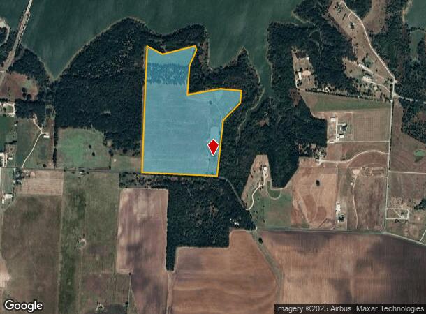
Emberson Chapel Rd
Sherman-Denison, TX
Dailey H W A-G0360
134918
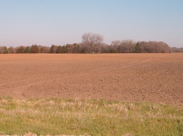
G-0360 DAILEY H W A-G0360, ACRES 72.333
Farms
Grayson
X
Texas
48121C0125G
72.33 AC
2024
Pilot Point
2025
Other Market Areas
020129
NEARBY LISTINGS FOR SALE OR LEASE
DEMOGRAPHICS near Emberson Chapel Rd
1 mile
3 mile
5 mile
2024 Total Population
45
2,124
7,132
2029 Population
50
2,424
8,390
Pop Growth 2024-2029
+ 11.11%
+ 14.12%
+ 17.64%
Average Age
39
39
40
2024 Total Households
17
768
2,556
HH Growth 2024-2029
+ 11.76%
+ 14.58%
+ 18.11%
Median Household Inc
$81,250
$76,720
$83,561
Avg Household Size
2.60
2.80
2.70
2024 Avg HH Vehicles
2.00
2.00
2.00
Median Home Value
$342,857
$333,071
$297,486
Median Year Built
1988
1990
1990
Nearby Places
Map Layers
Map Styles
 Street
 Aerial
Transit
 Traffic
 Biking
Places
Listings with unknown addresses are not visible on the map
- Restaurants
- Banks
- Shops
- Fitness
- Groceries
Nearby Properties
Address
Land Use
TOTAL SIZE
Lot Size
Zoning
Address
Land Use
TOTAL SIZE
Lot Size
Zoning
118,721 SF
4.68 AC
Address
Land Use
TOTAL SIZE
Lot Size
Zoning
210,260 SF
17.39 AC
Address
Land Use
TOTAL SIZE
Lot Size
Zoning
229 AC
Address
Land Use
TOTAL SIZE
Lot Size
Zoning
83,280 SF
8.08 AC
Address
Land Use
TOTAL SIZE
Lot Size
Zoning
114.38 AC
Address
Land Use
TOTAL SIZE
Lot Size
Zoning
109.97 AC
Address
Land Use
TOTAL SIZE
Lot Size
Zoning
19,558 SF
2.53 AC
Address
Land Use
TOTAL SIZE
Lot Size
Zoning
101.89 AC
Address
Land Use
TOTAL SIZE
Lot Size
Zoning
101.73 AC
Address
Land Use
TOTAL SIZE
Lot Size
Zoning
51,500 SF
10 AC
Address
Land Use
TOTAL SIZE
Lot Size
Zoning
1,962 SF
8 AC
Address
Land Use
TOTAL SIZE
Lot Size
Zoning
83.09 AC
Address
Land Use
TOTAL SIZE
Lot Size
Zoning
79.66 AC
Address
Land Use
TOTAL SIZE
Lot Size
Zoning
74.71 AC
Address
Land Use
TOTAL SIZE
Lot Size
Zoning
8,640 SF
16.40 AC
Address
Land Use
TOTAL SIZE
Lot Size
Zoning
68.50 AC
Address
Land Use
TOTAL SIZE
Lot Size
Zoning
67.36 AC
Address
Land Use
TOTAL SIZE
Lot Size
Zoning
1,200 SF
15 AC
Address
Land Use
TOTAL SIZE
Lot Size
Zoning
Address
Land Use
TOTAL SIZE
Lot Size
Zoning
41,862 SF
3.25 AC
Address
Land Use
TOTAL SIZE
Lot Size
Zoning
20,725 SF
1.86 AC
Address
Land Use
TOTAL SIZE
Lot Size
Zoning
9,400 SF
0.98 AC
Address
Land Use
TOTAL SIZE
Lot Size
Zoning
1,732 SF
48.93 AC
Address
Land Use
TOTAL SIZE
Lot Size
Zoning
23,276 SF
0.93 AC
12A
Address
Land Use
TOTAL SIZE
Lot Size
Zoning
23,808 SF
1.88 AC
Address
Land Use
TOTAL SIZE
Lot Size
Zoning
8,034 SF
20.38 AC
Address
Land Use
TOTAL SIZE
Lot Size
Zoning
43.73 AC
Address
Land Use
TOTAL SIZE
Lot Size
Zoning
42,060 SF
2.10 AC
Address
Land Use
TOTAL SIZE
Lot Size
Zoning
43.21 AC
Address
Land Use
TOTAL SIZE
Lot Size
Zoning
25,665 SF
0.64 AC
The World's #1 Commercial Real Estate Marketplace
Connect with us
© 2026 CoStar Group
The information above has been obtained from sources believed reliable. While we do not doubt its accuracy we have not verified it and make no guarantee, warranty or representation about it. It is your responsibility to independently confirm its accuracy and completeness. Any projections, opinions, assumptions, or estimates used are for example only and do not represent the current or future performance of the property. The value of this transaction to you depends on tax and other factors which should be evaluated by your tax, financial, and legal advisors. You and your advisors should conduct a careful, independent investigation of the property to determine to your satisfaction the suitability of the property for your needs.